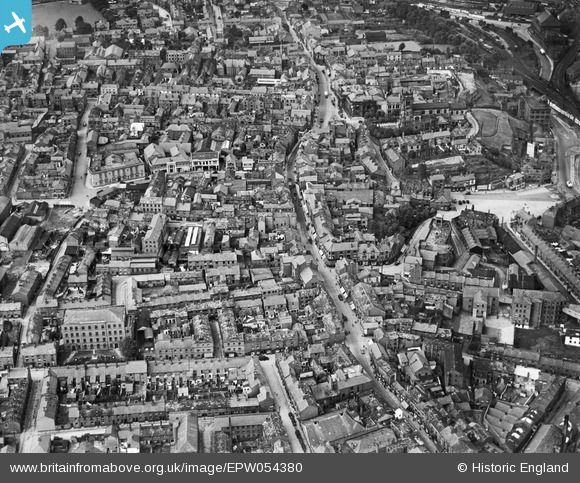
EPW054380 ENGLAND (1937). Mill Street and the town centre, Macclesfield, 1937
© Copyright OpenStreetMap contributors and licensed by the OpenStreetMap Foundation. 2026. Cartography is licensed as CC BY-SA.
Nearby Images (16)
Details
| Title | [EPW054380] Mill Street and the town centre, Macclesfield, 1937 |
| Reference | EPW054380 |
| Date | 20-July-1937 |
| Link | |
| Place name | MACCLESFIELD |
| Parish | |
| District | |
| Country | ENGLAND |
| Easting / Northing | 391683, 373558 |
| Longitude / Latitude | -2.1246886678983, 53.258682550574 |
| National Grid Reference | SJ917736 |
Pins

jonnyhud |
Tuesday 1st of March 2016 08:48:18 PM | |

Tony Carter |
Thursday 13th of November 2014 07:08:27 AM | |

Tony Carter |
Thursday 13th of November 2014 07:06:10 AM | |

jonnyhud |
Tuesday 5th of November 2013 09:59:01 PM | |

jonnyhud |
Tuesday 5th of November 2013 09:57:53 PM | |

jonnyhud |
Tuesday 5th of November 2013 09:54:48 PM | |

jonnyhud |
Tuesday 5th of November 2013 09:50:07 PM | |

jonnyhud |
Tuesday 5th of November 2013 09:48:45 PM | |

jonnyhud |
Tuesday 5th of November 2013 09:45:57 PM |


![[EPW054380] Mill Street and the town centre, Macclesfield, 1937](http://britainfromabove.org.uk/sites/all/libraries/aerofilms-images/public/100x100/EPW/054/EPW054380.jpg)
![[EPW057639] The town centre, Macclesfield, 1938. This image has been produced from a damaged negative.](http://britainfromabove.org.uk/sites/all/libraries/aerofilms-images/public/100x100/EPW/057/EPW057639.jpg)
![[EPW057374] St Michael's Church, Mill Street and the town centre, Macclesfield, 1938](http://britainfromabove.org.uk/sites/all/libraries/aerofilms-images/public/100x100/EPW/057/EPW057374.jpg)
![[EPW054374] Mill Street and the town centre, Macclesfield, 1937. This image has been produced from a copy-negative.](http://britainfromabove.org.uk/sites/all/libraries/aerofilms-images/public/100x100/EPW/054/EPW054374.jpg)
![[EPW054378] Castle Street, St Michael's Church and the town centre, Macclesfield, 1937](http://britainfromabove.org.uk/sites/all/libraries/aerofilms-images/public/100x100/EPW/054/EPW054378.jpg)
![[EPW016737] The town centre, Macclesfield, 1926. This image has been produced from a damaged copy-negative.](http://britainfromabove.org.uk/sites/all/libraries/aerofilms-images/public/100x100/EPW/016/EPW016737.jpg)
![[EPW057641] Oxford Street, Boden Street and environs, Macclesfield, 1938](http://britainfromabove.org.uk/sites/all/libraries/aerofilms-images/public/100x100/EPW/057/EPW057641.jpg)
![[EPW054379] The Railway Station, Waters Green and the town centre, Macclesfield, 1937](http://britainfromabove.org.uk/sites/all/libraries/aerofilms-images/public/100x100/EPW/054/EPW054379.jpg)
![[EPW050709] The Finishing Mill (Silk), the Marlborough Mill and the John Clayton Ltd Timber Yard, Macclesfield, 1936. This image has been affected by flare.](http://britainfromabove.org.uk/sites/all/libraries/aerofilms-images/public/100x100/EPW/050/EPW050709.jpg)
![[EPW050707] The Finishing Mill (Silk), the Marlborough Mill and the John Clayton Ltd Timber Yard, Macclesfield, 1936](http://britainfromabove.org.uk/sites/all/libraries/aerofilms-images/public/100x100/EPW/050/EPW050707.jpg)
![[EPW054375] St Michael's Church, the Market Place and environs, Macclesfield, 1937. This image has been produced from a copy-negative.](http://britainfromabove.org.uk/sites/all/libraries/aerofilms-images/public/100x100/EPW/054/EPW054375.jpg)
![[EPW050706] The Finishing Mill (Silk), the Marlborough Mill and the John Clayton Ltd Timber Yard, Macclesfield, 1936](http://britainfromabove.org.uk/sites/all/libraries/aerofilms-images/public/100x100/EPW/050/EPW050706.jpg)
![[EPW057375] St Michael's Church, the Market Place and the town centre, Macclesfield, 1938](http://britainfromabove.org.uk/sites/all/libraries/aerofilms-images/public/100x100/EPW/057/EPW057375.jpg)
![[EPW050708] The Finishing Mill (Silk), the Marlborough Mill and the John Clayton Ltd Timber Yard, Macclesfield, 1936](http://britainfromabove.org.uk/sites/all/libraries/aerofilms-images/public/100x100/EPW/050/EPW050708.jpg)
![[EPW054376] The town centre, Macclesfield, 1937](http://britainfromabove.org.uk/sites/all/libraries/aerofilms-images/public/100x100/EPW/054/EPW054376.jpg)
![[EPW016745] Park Green and environs, Macclesfield, 1926](http://britainfromabove.org.uk/sites/all/libraries/aerofilms-images/public/100x100/EPW/016/EPW016745.jpg)