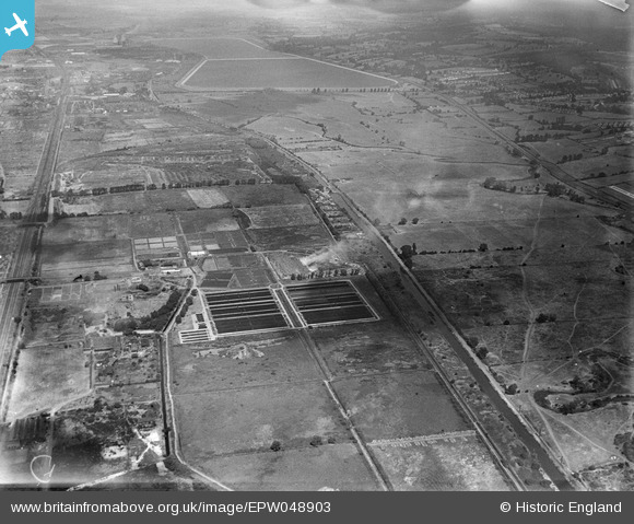
EPW048903 ENGLAND (1935). The Edmonton Council Sewage Works alongside the site of the William Girling Reservoir, Upper Edmonton, 1935
© Copyright OpenStreetMap contributors and licensed by the OpenStreetMap Foundation. 2026. Cartography is licensed as CC BY-SA.
Nearby Images (16)
Details
| Title | [EPW048903] The Edmonton Council Sewage Works alongside the site of the William Girling Reservoir, Upper Edmonton, 1935 |
| Reference | EPW048903 |
| Date | August-1935 |
| Link | |
| Place name | UPPER EDMONTON |
| Parish | |
| District | |
| Country | ENGLAND |
| Easting / Northing | 536055, 193386 |
| Longitude / Latitude | -0.034369199609476, 51.622356331146 |
| National Grid Reference | TQ361934 |
Pins
Be the first to add a comment to this image!


![[EPW048903] The Edmonton Council Sewage Works alongside the site of the William Girling Reservoir, Upper Edmonton, 1935](http://britainfromabove.org.uk/sites/all/libraries/aerofilms-images/public/100x100/EPW/048/EPW048903.jpg)
![[EPW046021] Edmonton Urban District Council Sewage Farm, Edmonton, 1934](http://britainfromabove.org.uk/sites/all/libraries/aerofilms-images/public/100x100/EPW/046/EPW046021.jpg)
![[EPW046015] Edmonton Urban District Council Sewage Farm, Edmonton, from the south-east, 1934](http://britainfromabove.org.uk/sites/all/libraries/aerofilms-images/public/100x100/EPW/046/EPW046015.jpg)
![[EPW046016] Edmonton Urban District Council Sewage Farm, Edmonton, from the north-east, 1934](http://britainfromabove.org.uk/sites/all/libraries/aerofilms-images/public/100x100/EPW/046/EPW046016.jpg)
![[EPW049531] Edmonton U.D. Council Sewage Farm and environs, Lower Edmonton, 1935](http://britainfromabove.org.uk/sites/all/libraries/aerofilms-images/public/100x100/EPW/049/EPW049531.jpg)
![[EPW046014] Edmonton Urban District Council Sewage Farm, Edmonton, 1934. This image has been affected by flare.](http://britainfromabove.org.uk/sites/all/libraries/aerofilms-images/public/100x100/EPW/046/EPW046014.jpg)
![[EPW049699] Edmonton Urban District Council Sewage Farm, Edmonton, 1936](http://britainfromabove.org.uk/sites/all/libraries/aerofilms-images/public/100x100/EPW/049/EPW049699.jpg)
![[EPW046019] Edmonton Urban District Council Sewage Farm, Edmonton, 1934](http://britainfromabove.org.uk/sites/all/libraries/aerofilms-images/public/100x100/EPW/046/EPW046019.jpg)
![[EPW046018] Edmonton Urban District Council Sewage Farm, Edmonton, 1934](http://britainfromabove.org.uk/sites/all/libraries/aerofilms-images/public/100x100/EPW/046/EPW046018.jpg)
![[EPW049526] Edmonton U.D. Council Sewage Farm and Filter Beds, Lower Edmonton, 1935](http://britainfromabove.org.uk/sites/all/libraries/aerofilms-images/public/100x100/EPW/049/EPW049526.jpg)
![[EPW049720] Edmonton Urban District Council Sewage Farm, Edmonton, 1936](http://britainfromabove.org.uk/sites/all/libraries/aerofilms-images/public/100x100/EPW/049/EPW049720.jpg)
![[EPW060209] The southern part of the Chingford (William Girling) Reservoir under construction, Edmonton, 1938](http://britainfromabove.org.uk/sites/all/libraries/aerofilms-images/public/100x100/EPW/060/EPW060209.jpg)
![[EPW049721] Edmonton Urban District Council Sewage Farm, Edmonton, 1936](http://britainfromabove.org.uk/sites/all/libraries/aerofilms-images/public/100x100/EPW/049/EPW049721.jpg)
![[EPW050862] The site of the William Girling Reservoir showing preliminary construction works, Edmonton, 1936](http://britainfromabove.org.uk/sites/all/libraries/aerofilms-images/public/100x100/EPW/050/EPW050862.jpg)
![[EPW046020] Edmonton Urban District Council Sewage Farm and environs, Edmonton, 1934. This image has been produced from a copy-negative.](http://britainfromabove.org.uk/sites/all/libraries/aerofilms-images/public/100x100/EPW/046/EPW046020.jpg)
![[EPW049707] Edmonton Urban District Council Sewage Farm, Edmonton, 1936](http://britainfromabove.org.uk/sites/all/libraries/aerofilms-images/public/100x100/EPW/049/EPW049707.jpg)