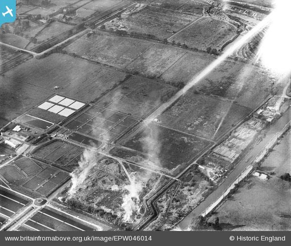
EPW046014 ENGLAND (1934). Edmonton Urban District Council Sewage Farm, Edmonton, 1934. This image has been affected by flare.
© Copyright OpenStreetMap contributors and licensed by the OpenStreetMap Foundation. 2026. Cartography is licensed as CC BY-SA.
Nearby Images (13)
Details
| Title | [EPW046014] Edmonton Urban District Council Sewage Farm, Edmonton, 1934. This image has been affected by flare. |
| Reference | EPW046014 |
| Date | September-1934 |
| Link | |
| Place name | EDMONTON |
| Parish | |
| District | |
| Country | ENGLAND |
| Easting / Northing | 536001, 193552 |
| Longitude / Latitude | -0.035084399931793, 51.6238612317 |
| National Grid Reference | TQ360936 |
Pins
Be the first to add a comment to this image!


![[EPW046014] Edmonton Urban District Council Sewage Farm, Edmonton, 1934. This image has been affected by flare.](http://britainfromabove.org.uk/sites/all/libraries/aerofilms-images/public/100x100/EPW/046/EPW046014.jpg)
![[EPW046018] Edmonton Urban District Council Sewage Farm, Edmonton, 1934](http://britainfromabove.org.uk/sites/all/libraries/aerofilms-images/public/100x100/EPW/046/EPW046018.jpg)
![[EPW046015] Edmonton Urban District Council Sewage Farm, Edmonton, from the south-east, 1934](http://britainfromabove.org.uk/sites/all/libraries/aerofilms-images/public/100x100/EPW/046/EPW046015.jpg)
![[EPW049707] Edmonton Urban District Council Sewage Farm, Edmonton, 1936](http://britainfromabove.org.uk/sites/all/libraries/aerofilms-images/public/100x100/EPW/049/EPW049707.jpg)
![[EPW046020] Edmonton Urban District Council Sewage Farm and environs, Edmonton, 1934. This image has been produced from a copy-negative.](http://britainfromabove.org.uk/sites/all/libraries/aerofilms-images/public/100x100/EPW/046/EPW046020.jpg)
![[EPW046446] Edmonton U.D. Council Sewage Farm, land around Pickett's Lock Lane and environs, Lower Edmonton, 1934](http://britainfromabove.org.uk/sites/all/libraries/aerofilms-images/public/100x100/EPW/046/EPW046446.jpg)
![[EPW048903] The Edmonton Council Sewage Works alongside the site of the William Girling Reservoir, Upper Edmonton, 1935](http://britainfromabove.org.uk/sites/all/libraries/aerofilms-images/public/100x100/EPW/048/EPW048903.jpg)
![[EPW046016] Edmonton Urban District Council Sewage Farm, Edmonton, from the north-east, 1934](http://britainfromabove.org.uk/sites/all/libraries/aerofilms-images/public/100x100/EPW/046/EPW046016.jpg)
![[EPW046445] Edmonton U.D. Council Sewage Farm, land around Pickett's Lock Lane and environs, Lower Edmonton, 1934](http://britainfromabove.org.uk/sites/all/libraries/aerofilms-images/public/100x100/EPW/046/EPW046445.jpg)
![[EPW049708] Aggregates extraction to the north of the Edmonton Urban District Council Sewage Farm, Edmonton, 1936](http://britainfromabove.org.uk/sites/all/libraries/aerofilms-images/public/100x100/EPW/049/EPW049708.jpg)
![[EPW046021] Edmonton Urban District Council Sewage Farm, Edmonton, 1934](http://britainfromabove.org.uk/sites/all/libraries/aerofilms-images/public/100x100/EPW/046/EPW046021.jpg)
![[EPW049526] Edmonton U.D. Council Sewage Farm and Filter Beds, Lower Edmonton, 1935](http://britainfromabove.org.uk/sites/all/libraries/aerofilms-images/public/100x100/EPW/049/EPW049526.jpg)
![[EPW049720] Edmonton Urban District Council Sewage Farm, Edmonton, 1936](http://britainfromabove.org.uk/sites/all/libraries/aerofilms-images/public/100x100/EPW/049/EPW049720.jpg)