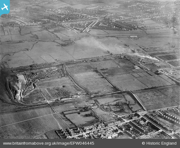
EPW046445 ENGLAND (1934). Edmonton U.D. Council Sewage Farm, land around Pickett's Lock Lane and environs, Lower Edmonton, 1934
© Copyright OpenStreetMap contributors and licensed by the OpenStreetMap Foundation. 2026. Cartography is licensed as CC BY-SA.
Nearby Images (10)
Details
| Title | [EPW046445] Edmonton U.D. Council Sewage Farm, land around Pickett's Lock Lane and environs, Lower Edmonton, 1934 |
| Reference | EPW046445 |
| Date | October-1934 |
| Link | |
| Place name | LOWER EDMONTON |
| Parish | |
| District | |
| Country | ENGLAND |
| Easting / Northing | 536046, 193741 |
| Longitude / Latitude | -0.034361237325027, 51.625548899511 |
| National Grid Reference | TQ360937 |
Pins

G.Martin |
Tuesday 17th of June 2014 04:10:54 PM | |

eddymonton |
Saturday 1st of March 2014 06:34:22 PM | |

eddymonton |
Saturday 1st of March 2014 06:33:19 PM |


![[EPW046445] Edmonton U.D. Council Sewage Farm, land around Pickett's Lock Lane and environs, Lower Edmonton, 1934](http://britainfromabove.org.uk/sites/all/libraries/aerofilms-images/public/100x100/EPW/046/EPW046445.jpg)
![[EPW049708] Aggregates extraction to the north of the Edmonton Urban District Council Sewage Farm, Edmonton, 1936](http://britainfromabove.org.uk/sites/all/libraries/aerofilms-images/public/100x100/EPW/049/EPW049708.jpg)
![[EPW046444] Edmonton U.D. Council Sewage Farm and land around Pickett's Lock Lane, Lower Edmonton, 1934](http://britainfromabove.org.uk/sites/all/libraries/aerofilms-images/public/100x100/EPW/046/EPW046444.jpg)
![[EPW046446] Edmonton U.D. Council Sewage Farm, land around Pickett's Lock Lane and environs, Lower Edmonton, 1934](http://britainfromabove.org.uk/sites/all/libraries/aerofilms-images/public/100x100/EPW/046/EPW046446.jpg)
![[EPW046447] Edmonton U.D. Council Sewage Farm, land around Pickett's Lock Lane and environs, Lower Edmonton, 1934](http://britainfromabove.org.uk/sites/all/libraries/aerofilms-images/public/100x100/EPW/046/EPW046447.jpg)
![[EPW046014] Edmonton Urban District Council Sewage Farm, Edmonton, 1934. This image has been affected by flare.](http://britainfromabove.org.uk/sites/all/libraries/aerofilms-images/public/100x100/EPW/046/EPW046014.jpg)
![[EPW049707] Edmonton Urban District Council Sewage Farm, Edmonton, 1936](http://britainfromabove.org.uk/sites/all/libraries/aerofilms-images/public/100x100/EPW/049/EPW049707.jpg)
![[EPW046018] Edmonton Urban District Council Sewage Farm, Edmonton, 1934](http://britainfromabove.org.uk/sites/all/libraries/aerofilms-images/public/100x100/EPW/046/EPW046018.jpg)
![[EPW046020] Edmonton Urban District Council Sewage Farm and environs, Edmonton, 1934. This image has been produced from a copy-negative.](http://britainfromabove.org.uk/sites/all/libraries/aerofilms-images/public/100x100/EPW/046/EPW046020.jpg)
![[EPW049526] Edmonton U.D. Council Sewage Farm and Filter Beds, Lower Edmonton, 1935](http://britainfromabove.org.uk/sites/all/libraries/aerofilms-images/public/100x100/EPW/049/EPW049526.jpg)