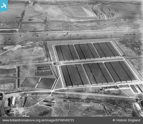
EPW049721 ENGLAND (1936). Edmonton Urban District Council Sewage Farm, Edmonton, 1936
© Copyright OpenStreetMap contributors and licensed by the OpenStreetMap Foundation. 2026. Cartography is licensed as CC BY-SA.
Nearby Images (10)
Details
| Title | [EPW049721] Edmonton Urban District Council Sewage Farm, Edmonton, 1936 |
| Reference | EPW049721 |
| Date | March-1936 |
| Link | |
| Place name | EDMONTON |
| Parish | |
| District | |
| Country | ENGLAND |
| Easting / Northing | 535909, 193194 |
| Longitude / Latitude | -0.03655167455898, 51.620666103432 |
| National Grid Reference | TQ359932 |
Pins
Be the first to add a comment to this image!


![[EPW049721] Edmonton Urban District Council Sewage Farm, Edmonton, 1936](http://britainfromabove.org.uk/sites/all/libraries/aerofilms-images/public/100x100/EPW/049/EPW049721.jpg)
![[EPW046019] Edmonton Urban District Council Sewage Farm, Edmonton, 1934](http://britainfromabove.org.uk/sites/all/libraries/aerofilms-images/public/100x100/EPW/046/EPW046019.jpg)
![[EPW049699] Edmonton Urban District Council Sewage Farm, Edmonton, 1936](http://britainfromabove.org.uk/sites/all/libraries/aerofilms-images/public/100x100/EPW/049/EPW049699.jpg)
![[EPW049531] Edmonton U.D. Council Sewage Farm and environs, Lower Edmonton, 1935](http://britainfromabove.org.uk/sites/all/libraries/aerofilms-images/public/100x100/EPW/049/EPW049531.jpg)
![[EPW048908] The Edmonton Council Sewage Farm alongside the site of the William Girling Reservoir, Upper Edmonton, from the west, 1935](http://britainfromabove.org.uk/sites/all/libraries/aerofilms-images/public/100x100/EPW/048/EPW048908.jpg)
![[EPW049720] Edmonton Urban District Council Sewage Farm, Edmonton, 1936](http://britainfromabove.org.uk/sites/all/libraries/aerofilms-images/public/100x100/EPW/049/EPW049720.jpg)
![[EPW046021] Edmonton Urban District Council Sewage Farm, Edmonton, 1934](http://britainfromabove.org.uk/sites/all/libraries/aerofilms-images/public/100x100/EPW/046/EPW046021.jpg)
![[EPW048903] The Edmonton Council Sewage Works alongside the site of the William Girling Reservoir, Upper Edmonton, 1935](http://britainfromabove.org.uk/sites/all/libraries/aerofilms-images/public/100x100/EPW/048/EPW048903.jpg)
![[EPW046015] Edmonton Urban District Council Sewage Farm, Edmonton, from the south-east, 1934](http://britainfromabove.org.uk/sites/all/libraries/aerofilms-images/public/100x100/EPW/046/EPW046015.jpg)
![[EPW049722] Edmonton Urban District Council Sewage Farm and the site of the southern end of the William Girling Reservoir showing preliminary construction works, Edmonton, 1936](http://britainfromabove.org.uk/sites/all/libraries/aerofilms-images/public/100x100/EPW/049/EPW049722.jpg)