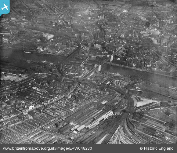
EPW048230 ENGLAND (1935). The Close Engineering Works, Tyne Bridge and environs, Gateshead, 1935
© Copyright OpenStreetMap contributors and licensed by the OpenStreetMap Foundation. 2026. Cartography is licensed as CC BY-SA.
Nearby Images (22)
Details
| Title | [EPW048230] The Close Engineering Works, Tyne Bridge and environs, Gateshead, 1935 |
| Reference | EPW048230 |
| Date | July-1935 |
| Link | |
| Place name | GATESHEAD |
| Parish | |
| District | |
| Country | ENGLAND |
| Easting / Northing | 425387, 563644 |
| Longitude / Latitude | -1.6034219375401, 54.966697269579 |
| National Grid Reference | NZ254636 |
Pins

Chells809 |
Friday 15th of November 2013 08:27:48 PM | |

Chells809 |
Friday 15th of November 2013 08:26:42 PM | |

Chells809 |
Friday 15th of November 2013 08:25:25 PM | |

Chells809 |
Friday 15th of November 2013 08:23:51 PM |


![[EPW048230] The Close Engineering Works, Tyne Bridge and environs, Gateshead, 1935](http://britainfromabove.org.uk/sites/all/libraries/aerofilms-images/public/100x100/EPW/048/EPW048230.jpg)
![[EPW019832] The Tyne Bridge under construction, Gateshead, 1927](http://britainfromabove.org.uk/sites/all/libraries/aerofilms-images/public/100x100/EPW/019/EPW019832.jpg)
![[EPW048235] Tyne Bridge, Gateshead, 1935](http://britainfromabove.org.uk/sites/all/libraries/aerofilms-images/public/100x100/EPW/048/EPW048235.jpg)
![[EPW048345] The Tyne Bridge, Newcastle Swing Bridge and the River Tyne, Newcastle upon Tyne, 1935](http://britainfromabove.org.uk/sites/all/libraries/aerofilms-images/public/100x100/EPW/048/EPW048345.jpg)
![[EPW048805] The High Level Bridge, Newcastle Swing Bridge, Tyne Bridge and the city, Newcastle upon Tyne, from the south-west, 1935. This image has been produced from a print.](http://britainfromabove.org.uk/sites/all/libraries/aerofilms-images/public/100x100/EPW/048/EPW048805.jpg)
![[EPW025016] Newcastle-upon-Tyne, the day of the opening of the Tyne Bridge, 1928. This image has been produced from a copy-negative.](http://britainfromabove.org.uk/sites/all/libraries/aerofilms-images/public/100x100/EPW/025/EPW025016.jpg)
![[EPW048229] Tyne Bridge, Newcastle upon Tyne, 1935. This image has been produced from a damaged negative.](http://britainfromabove.org.uk/sites/all/libraries/aerofilms-images/public/100x100/EPW/048/EPW048229.jpg)
![[EPW054561] The Tyne Bridge, Newcastle Swing Bridge and the High Level Bridge, Newcastle upon Tyne, 1937](http://britainfromabove.org.uk/sites/all/libraries/aerofilms-images/public/100x100/EPW/054/EPW054561.jpg)
![[EPW054559] The Tyne Bridge, Newcastle Swing Bridge and the High Level Bridge, Newcastle upon Tyne, 1937](http://britainfromabove.org.uk/sites/all/libraries/aerofilms-images/public/100x100/EPW/054/EPW054559.jpg)
![[EPW020568] The Tyne Bridge under construction and the Newcastle Swing Bridge, Newcastle Upon Tyne, 1928](http://britainfromabove.org.uk/sites/all/libraries/aerofilms-images/public/100x100/EPW/020/EPW020568.jpg)
![[EPW048346] The Tyne Bridge, Newcastle Swing Bridge and the High Level Bridge, Newcastle upon Tyne, 1935](http://britainfromabove.org.uk/sites/all/libraries/aerofilms-images/public/100x100/EPW/048/EPW048346.jpg)
![[EPW020570] The Tyne Bridge under construction, Newcastle Upon Tyne, 1928](http://britainfromabove.org.uk/sites/all/libraries/aerofilms-images/public/100x100/EPW/020/EPW020570.jpg)
![[EPW019820] Newcastle Swing Bridge, High Level Railway Bridge and Tyne Bridge under construction, Newcastle upon Tyne, 1927](http://britainfromabove.org.uk/sites/all/libraries/aerofilms-images/public/100x100/EPW/019/EPW019820.jpg)
![[EPW048799] The Tyne Bridge, Newcastle Swing Bridge and environs, Newcastle Upon Tyne, 1935](http://britainfromabove.org.uk/sites/all/libraries/aerofilms-images/public/100x100/EPW/048/EPW048799.jpg)
![[EPW020569] The Tyne Bridge under construction, Newcastle Upon Tyne, 1928](http://britainfromabove.org.uk/sites/all/libraries/aerofilms-images/public/100x100/EPW/020/EPW020569.jpg)
![[EPW025015] Newcastle-upon-Tyne, the day of the opening of the Tyne Bridge, 1928](http://britainfromabove.org.uk/sites/all/libraries/aerofilms-images/public/100x100/EPW/025/EPW025015.jpg)
![[EAW405203] Bridges over the River Tyne, Newcastle upon Tyne, from the north-east, 1981](http://britainfromabove.org.uk/sites/all/libraries/aerofilms-images/public/100x100/EAW/405/EAW405203.jpg)
![[EPW048263] Tyne Bridge and the surrounding urban area, Newcastle upon Tyne, 1935. This image has been produced from a damaged negative.](http://britainfromabove.org.uk/sites/all/libraries/aerofilms-images/public/100x100/EPW/048/EPW048263.jpg)
![[EPW010393] The High Level Bridge and Newcastle Swing Bridge, Newcastle upon Tyne, 1924. This image has been produced from a print.](http://britainfromabove.org.uk/sites/all/libraries/aerofilms-images/public/100x100/EPW/010/EPW010393.jpg)
![[EPW048800] The High Level Bridge, Newcastle Swing Bridge and Tyne Bridge, Newcastle Upon Tyne, 1935. This image has been produced from a copy-negative.](http://britainfromabove.org.uk/sites/all/libraries/aerofilms-images/public/100x100/EPW/048/EPW048800.jpg)
![[EPW051090] High Street and environs, Gateshead, from the north, 1936](http://britainfromabove.org.uk/sites/all/libraries/aerofilms-images/public/100x100/EPW/051/EPW051090.jpg)
![[EPW051088] The British Ropes Ltd Wire Works, Gateshead, 1936](http://britainfromabove.org.uk/sites/all/libraries/aerofilms-images/public/100x100/EPW/051/EPW051088.jpg)