
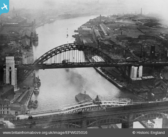
EPW025016 ENGLAND (1928). Newcastle-upon-Tyne, the day of the opening of the Tyne Bridge, 1928. This image has been produced from a copy-negative.
© Copyright OpenStreetMap contributors and licensed by the OpenStreetMap Foundation. 2026. Cartography is licensed as CC BY-SA.
Nearby Images (22)
EPW025016

EPW054561

EPW020568

EPW048345

EPW048229

EPW054559

EPW019820

EPW020570

EPW048805

EPW048346

EPW048235

EPW020569

EPW025015

EPW048799

EPW048263

EPW048230

EPW010393

EPW048800

EPW048803

EAW405203

EPW019832

EPW051090

Details
| Title | [EPW025016] Newcastle-upon-Tyne, the day of the opening of the Tyne Bridge, 1928. This image has been produced from a copy-negative. |
| Reference | EPW025016 |
| Date | 10-October-1928 |
| Link | |
| Place name | NEWCASTLE-UPON-TYNE |
| Parish | |
| District | |
| Country | ENGLAND |
| Easting / Northing | 425317, 563782 |
| Longitude / Latitude | -1.604503215436, 54.96794104349 |
| National Grid Reference | NZ253638 |
Pins
Be the first to add a comment to this image!