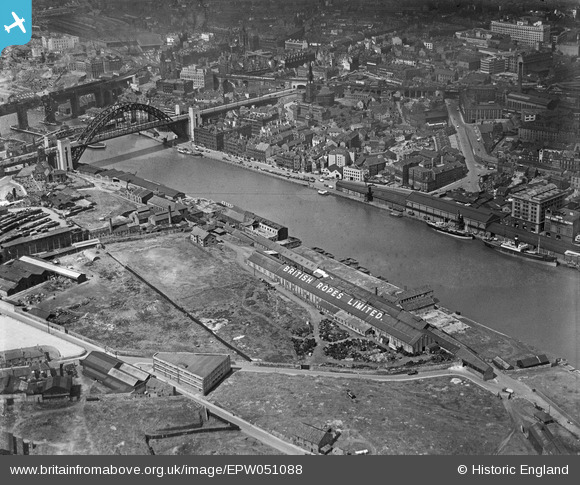
EPW051088 ENGLAND (1936). The British Ropes Ltd Wire Works, Gateshead, 1936
© Copyright OpenStreetMap contributors and licensed by the OpenStreetMap Foundation. 2026. Cartography is licensed as CC BY-SA.
Nearby Images (16)
Details
| Title | [EPW051088] The British Ropes Ltd Wire Works, Gateshead, 1936 |
| Reference | EPW051088 |
| Date | July-1936 |
| Link | |
| Place name | GATESHEAD |
| Parish | |
| District | |
| Country | ENGLAND |
| Easting / Northing | 425632, 563873 |
| Longitude / Latitude | -1.5995743504557, 54.9687427641 |
| National Grid Reference | NZ256639 |
Pins

MethodistArchivist |
Tuesday 5th of November 2013 02:22:37 PM | |

MethodistArchivist |
Tuesday 5th of November 2013 02:21:40 PM |


![[EPW051088] The British Ropes Ltd Wire Works, Gateshead, 1936](http://britainfromabove.org.uk/sites/all/libraries/aerofilms-images/public/100x100/EPW/051/EPW051088.jpg)
![[EPW051086] The British Ropes Ltd Wire Works, Gateshead, 1936](http://britainfromabove.org.uk/sites/all/libraries/aerofilms-images/public/100x100/EPW/051/EPW051086.jpg)
![[EPW051087] The British Ropes Ltd Wire Works, Gateshead, 1936](http://britainfromabove.org.uk/sites/all/libraries/aerofilms-images/public/100x100/EPW/051/EPW051087.jpg)
![[EPW051090] High Street and environs, Gateshead, from the north, 1936](http://britainfromabove.org.uk/sites/all/libraries/aerofilms-images/public/100x100/EPW/051/EPW051090.jpg)
![[EPW051085] The British Ropes Ltd Wire Works, Gateshead, 1936](http://britainfromabove.org.uk/sites/all/libraries/aerofilms-images/public/100x100/EPW/051/EPW051085.jpg)
![[EPW048807] The High Level Bridge, Newcastle Swing Bridge, Tyne Bridge and environs, Newcastle upon Tyne, 1935. This image has been produced from a print.](http://britainfromabove.org.uk/sites/all/libraries/aerofilms-images/public/100x100/EPW/048/EPW048807.jpg)
![[EPW051089] The British Ropes Ltd Wire Works, Gateshead, 1936](http://britainfromabove.org.uk/sites/all/libraries/aerofilms-images/public/100x100/EPW/051/EPW051089.jpg)
![[EPW048801] The High Level Bridge, Newcastle Swing Bridge, Tyne Bridge and the city, Newcastle upon Tyne, 1935. This image has been produced from a print.](http://britainfromabove.org.uk/sites/all/libraries/aerofilms-images/public/100x100/EPW/048/EPW048801.jpg)
![[EPW051084] The British Ropes Ltd Wire Works, Gateshead, 1936](http://britainfromabove.org.uk/sites/all/libraries/aerofilms-images/public/100x100/EPW/051/EPW051084.jpg)
![[EAW600907] Tyne Bridge, Newcastle upon Tyne, 1991](http://britainfromabove.org.uk/sites/all/libraries/aerofilms-images/public/100x100/EAW/600/EAW600907.jpg)
![[EPW048234] Salt Meadows and environs alongside the River Tyne, Gateshead, 1935](http://britainfromabove.org.uk/sites/all/libraries/aerofilms-images/public/100x100/EPW/048/EPW048234.jpg)
![[EPW048803] Tyne Bridge, the Quayside and environs, Newcastle Upon Tyne, 1935. This image has been produced from a copy-negative.](http://britainfromabove.org.uk/sites/all/libraries/aerofilms-images/public/100x100/EPW/048/EPW048803.jpg)
![[EPW048799] The Tyne Bridge, Newcastle Swing Bridge and environs, Newcastle Upon Tyne, 1935](http://britainfromabove.org.uk/sites/all/libraries/aerofilms-images/public/100x100/EPW/048/EPW048799.jpg)
![[EAW037008] The Baltic Flour Mills and British Ropes Ltd Rope Works, Gateshead, 1951. This image has been produced from a print marked by Aerofilms Ltd for photo editing.](http://britainfromabove.org.uk/sites/all/libraries/aerofilms-images/public/100x100/EAW/037/EAW037008.jpg)
![[EAW037012] The Baltic Flour Mills and British Ropes Ltd Rope Works, Gateshead, 1951. This image has been produced from a print marked by Aerofilms Ltd for photo editing.](http://britainfromabove.org.uk/sites/all/libraries/aerofilms-images/public/100x100/EAW/037/EAW037012.jpg)
![[EPW048230] The Close Engineering Works, Tyne Bridge and environs, Gateshead, 1935](http://britainfromabove.org.uk/sites/all/libraries/aerofilms-images/public/100x100/EPW/048/EPW048230.jpg)