
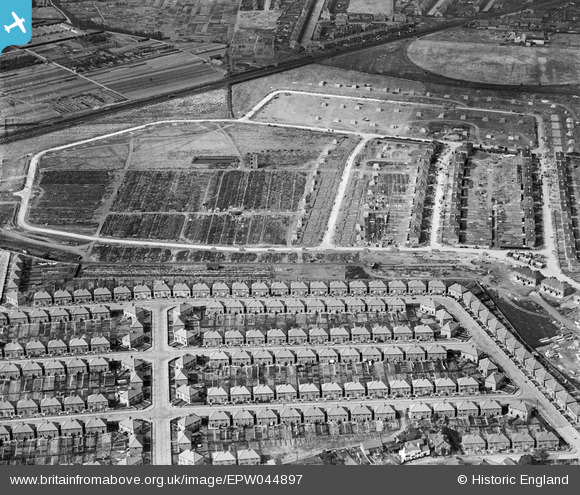
EPW044897 ENGLAND (1934). Construction of the Grosvenor Park Estate, Feltham, 1934
© Copyright OpenStreetMap contributors and licensed by the OpenStreetMap Foundation. 2026. Cartography is licensed as CC BY-SA.
Nearby Images (26)
EPW044897

EPR000007

EPR000002

EPR000009

EPW044353

EPW044549

EPW044898

EPW044354

EPR000008

EPW044895

EPW044550

EPW044899

EPW044520

EPW044896

EPW044900

EPW044547

EPW044548

EPR000004

EPW060358

EPR000003

EPW044551

EPW044355

EPR000142

EPR000143

EPR000147

EPR000005

Details
| Title | [EPW044897] Construction of the Grosvenor Park Estate, Feltham, 1934 |
| Reference | EPW044897 |
| Date | June-1934 |
| Link | |
| Place name | FELTHAM |
| Parish | |
| District | |
| Country | ENGLAND |
| Easting / Northing | 509949, 172706 |
| Longitude / Latitude | -0.41781603261021, 51.44217108356 |
| National Grid Reference | TQ099727 |
Pins

Mr Nozzle |
Tuesday 8th of October 2013 09:40:42 PM | |
|
AdrianB |
Wednesday 29th of May 2013 04:28:29 PM | |
|
AdrianB |
Wednesday 29th of May 2013 04:27:30 PM | |
|
AdrianB |
Wednesday 29th of May 2013 04:26:46 PM | |
|
AdrianB |
Wednesday 29th of May 2013 04:26:15 PM | |
|
AdrianB |
Wednesday 29th of May 2013 04:25:40 PM | |
|
AdrianB |
Wednesday 29th of May 2013 04:24:53 PM |