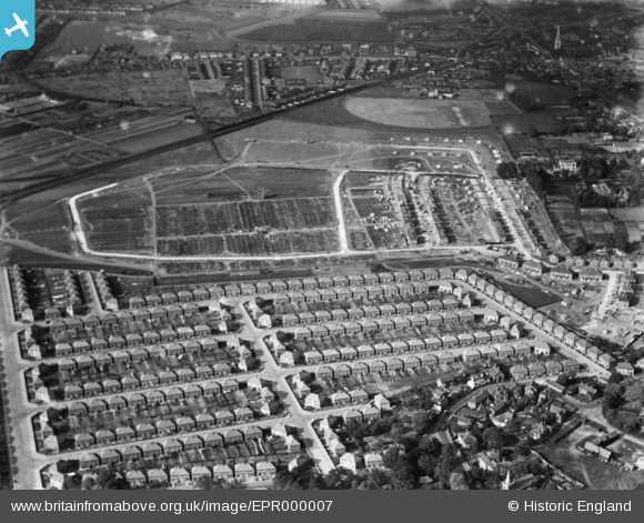
EPR000007 ENGLAND (1934). Housing estate under construction surrounding Grosvenor Park, Feltham, 1934
© Copyright OpenStreetMap contributors and licensed by the OpenStreetMap Foundation. 2025. Cartography is licensed as CC BY-SA.
Nearby Images (26)
Details
| Title | [EPR000007] Housing estate under construction surrounding Grosvenor Park, Feltham, 1934 |
| Reference | EPR000007 |
| Date | May-1934 |
| Link | |
| Place name | FELTHAM |
| Parish | |
| District | |
| Country | ENGLAND |
| Easting / Northing | 509950, 172697 |
| Longitude / Latitude | -0.4178044445799, 51.442089986922 |
| National Grid Reference | TQ100727 |
Pins
Be the first to add a comment to this image!


![[EPR000007] Housing estate under construction surrounding Grosvenor Park, Feltham, 1934](http://britainfromabove.org.uk/sites/all/libraries/aerofilms-images/public/100x100/EPR/000/EPR000007.jpg)
![[EPW044897] Construction of the Grosvenor Park Estate, Feltham, 1934](http://britainfromabove.org.uk/sites/all/libraries/aerofilms-images/public/100x100/EPW/044/EPW044897.jpg)
![[EPR000002] Housing estate under construction surrounding Grosvenor Park, Feltham, 1934](http://britainfromabove.org.uk/sites/all/libraries/aerofilms-images/public/100x100/EPR/000/EPR000002.jpg)
![[EPR000009] Housing estate under construction surrounding Grosvenor Park, Feltham, 1934](http://britainfromabove.org.uk/sites/all/libraries/aerofilms-images/public/100x100/EPR/000/EPR000009.jpg)
![[EPW044353] Housing estate adjacent to Grosvenor Park and environs, Feltham, 1934](http://britainfromabove.org.uk/sites/all/libraries/aerofilms-images/public/100x100/EPW/044/EPW044353.jpg)
![[EPW044549] The Grosvenor Park estate under construction, Feltham, 1934](http://britainfromabove.org.uk/sites/all/libraries/aerofilms-images/public/100x100/EPW/044/EPW044549.jpg)
![[EPW044898] Construction of the Grosvenor Park Estate, Feltham, 1934](http://britainfromabove.org.uk/sites/all/libraries/aerofilms-images/public/100x100/EPW/044/EPW044898.jpg)
![[EPW044354] Housing estate adjacent to Grosvenor Park and environs, Feltham, 1934](http://britainfromabove.org.uk/sites/all/libraries/aerofilms-images/public/100x100/EPW/044/EPW044354.jpg)
![[EPR000008] Housing estate under construction surrounding Grosvenor Park, Feltham, 1934](http://britainfromabove.org.uk/sites/all/libraries/aerofilms-images/public/100x100/EPR/000/EPR000008.jpg)
![[EPW044895] Construction of the Grosvenor Park Estate and environs, Feltham, 1934](http://britainfromabove.org.uk/sites/all/libraries/aerofilms-images/public/100x100/EPW/044/EPW044895.jpg)
![[EPW044550] The Grosvenor Park estate under construction, Feltham, 1934](http://britainfromabove.org.uk/sites/all/libraries/aerofilms-images/public/100x100/EPW/044/EPW044550.jpg)
![[EPW044520] Construction of the Grosvenor Park Estate and environs, Feltham, 1934](http://britainfromabove.org.uk/sites/all/libraries/aerofilms-images/public/100x100/EPW/044/EPW044520.jpg)
![[EPW044899] Construction of the Grosvenor Park Estate and environs, Feltham, 1934](http://britainfromabove.org.uk/sites/all/libraries/aerofilms-images/public/100x100/EPW/044/EPW044899.jpg)
![[EPW044896] Construction of the Grosvenor Park Estate, Feltham, 1934](http://britainfromabove.org.uk/sites/all/libraries/aerofilms-images/public/100x100/EPW/044/EPW044896.jpg)
![[EPW044900] Construction of the Grosvenor Park Estate, Feltham, 1934. This image has been produced from a damaged negative.](http://britainfromabove.org.uk/sites/all/libraries/aerofilms-images/public/100x100/EPW/044/EPW044900.jpg)
![[EPW044547] The Grosvenor Park estate under construction, Feltham, 1934](http://britainfromabove.org.uk/sites/all/libraries/aerofilms-images/public/100x100/EPW/044/EPW044547.jpg)
![[EPW044548] The Grosvenor Park estate under construction, Feltham, 1934](http://britainfromabove.org.uk/sites/all/libraries/aerofilms-images/public/100x100/EPW/044/EPW044548.jpg)
![[EPR000004] Housing estate under construction surrounding Grosvenor Park, Feltham, 1934](http://britainfromabove.org.uk/sites/all/libraries/aerofilms-images/public/100x100/EPR/000/EPR000004.jpg)
![[EPW060358] Housing development at Grosvenor Park, Feltham, 1939](http://britainfromabove.org.uk/sites/all/libraries/aerofilms-images/public/100x100/EPW/060/EPW060358.jpg)
![[EPR000003] Housing estate under construction surrounding Grosvenor Park, Feltham, 1934](http://britainfromabove.org.uk/sites/all/libraries/aerofilms-images/public/100x100/EPR/000/EPR000003.jpg)
![[EPW044355] Housing estate adjacent to Grosvenor Park, Feltham, 1934](http://britainfromabove.org.uk/sites/all/libraries/aerofilms-images/public/100x100/EPW/044/EPW044355.jpg)
![[EPW044551] The Grosvenor Park estate under construction, Feltham, 1934](http://britainfromabove.org.uk/sites/all/libraries/aerofilms-images/public/100x100/EPW/044/EPW044551.jpg)
![[EPR000147] The Grosvenor Park Estate under construction, Feltham, 1934](http://britainfromabove.org.uk/sites/all/libraries/aerofilms-images/public/100x100/EPR/000/EPR000147.jpg)
![[EPR000142] Construction of the Grosvenor Park Estate, Feltham, 1934. This image was marked by Aero Pictorial Ltd for photo editing.](http://britainfromabove.org.uk/sites/all/libraries/aerofilms-images/public/100x100/EPR/000/EPR000142.jpg)
![[EPR000143] Construction of the Grosvenor Park Estate, Feltham, 1934](http://britainfromabove.org.uk/sites/all/libraries/aerofilms-images/public/100x100/EPR/000/EPR000143.jpg)
![[EPR000005] Housing estate under construction surrounding Grosvenor Park, Feltham, 1934](http://britainfromabove.org.uk/sites/all/libraries/aerofilms-images/public/100x100/EPR/000/EPR000005.jpg)