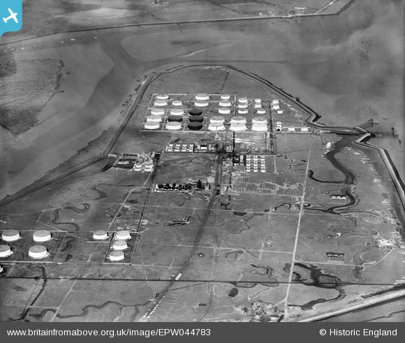
EPW044783 ENGLAND (1934). The Coryton Oil Refinery, Coryton, 1934
© Copyright OpenStreetMap contributors and licensed by the OpenStreetMap Foundation. 2026. Cartography is licensed as CC BY-SA.
Nearby Images (20)
Details
| Title | [EPW044783] The Coryton Oil Refinery, Coryton, 1934 |
| Reference | EPW044783 |
| Date | June-1934 |
| Link | |
| Place name | CORYTON |
| Parish | |
| District | |
| Country | ENGLAND |
| Easting / Northing | 575624, 182277 |
| Longitude / Latitude | 0.53121122181943, 51.511601245862 |
| National Grid Reference | TQ756823 |
Pins
Be the first to add a comment to this image!


![[EPW044783] The Coryton Oil Refinery, Coryton, 1934](http://britainfromabove.org.uk/sites/all/libraries/aerofilms-images/public/100x100/EPW/044/EPW044783.jpg)
![[EAW034432] Part of the Coryton Oil Refinery under construction, Coryton, from the east, 1951. This image has been produced from a print marked by Aerofilms Ltd for photo editing.](http://britainfromabove.org.uk/sites/all/libraries/aerofilms-images/public/100x100/EAW/034/EAW034432.jpg)
![[EAW048301] Flooding at the Coryton Oil Refinery, Coryton, from the east, 1953](http://britainfromabove.org.uk/sites/all/libraries/aerofilms-images/public/100x100/EAW/048/EAW048301.jpg)
![[EAW039887] The Coryton Oil Refinery, Coryton, from the east, 1951. This image has been produced from a damaged negative.](http://britainfromabove.org.uk/sites/all/libraries/aerofilms-images/public/100x100/EAW/039/EAW039887.jpg)
![[EPW044785] The Coryton Oil Refinery, Coryton, 1934](http://britainfromabove.org.uk/sites/all/libraries/aerofilms-images/public/100x100/EPW/044/EPW044785.jpg)
![[EAW048300] Flooding at the Coryton Oil Refinery, Coryton, from the east, 1953](http://britainfromabove.org.uk/sites/all/libraries/aerofilms-images/public/100x100/EAW/048/EAW048300.jpg)
![[EAW048370] Flooding at the Coryton Oil Refinery, Coryton, 1953. This image was marked by Aerofilms Ltd for photo editing.](http://britainfromabove.org.uk/sites/all/libraries/aerofilms-images/public/100x100/EAW/048/EAW048370.jpg)
![[EPW044784] The Coryton Oil Refinery, Coryton, 1934](http://britainfromabove.org.uk/sites/all/libraries/aerofilms-images/public/100x100/EPW/044/EPW044784.jpg)
![[EAW048360] Flooding at the Coryton Oil Refinery, Coryton, 1953. This image was marked by Aerofilms Ltd for photo editing.](http://britainfromabove.org.uk/sites/all/libraries/aerofilms-images/public/100x100/EAW/048/EAW048360.jpg)
![[EAW045738] The Coryton Oil Refinery, Coryton, 1952. This image was marked by Aerofilms Ltd for photo editing.](http://britainfromabove.org.uk/sites/all/libraries/aerofilms-images/public/100x100/EAW/045/EAW045738.jpg)
![[EAW048363] Flooding at the Coryton Oil Refinery, Coryton, from the south-west, 1953. This image was marked by Aerofilms Ltd for photo editing.](http://britainfromabove.org.uk/sites/all/libraries/aerofilms-images/public/100x100/EAW/048/EAW048363.jpg)
![[EAW034405] Part of the Coryton Oil Refinery under construction, Coryton, from the east, 1951. This image has been produced from a print marked by Aerofilms Ltd for photo editing.](http://britainfromabove.org.uk/sites/all/libraries/aerofilms-images/public/100x100/EAW/034/EAW034405.jpg)
![[EPW044787] The Coryton Oil Refinery, Coryton, 1934](http://britainfromabove.org.uk/sites/all/libraries/aerofilms-images/public/100x100/EPW/044/EPW044787.jpg)
![[EPW044782] The Coryton Oil Refinery, Coryton, 1934](http://britainfromabove.org.uk/sites/all/libraries/aerofilms-images/public/100x100/EPW/044/EPW044782.jpg)
![[EPW044786] The Coryton Oil Refinery, Coryton, 1934](http://britainfromabove.org.uk/sites/all/libraries/aerofilms-images/public/100x100/EPW/044/EPW044786.jpg)
![[EAW035773] The Coryton Oil Refinery, Coryton, 1951. This image has been produced from a print marked by Aerofilms Ltd for photo editing.](http://britainfromabove.org.uk/sites/all/libraries/aerofilms-images/public/100x100/EAW/035/EAW035773.jpg)
![[EAW043888] The Coryton Oil Refinery, Shell Haven, from the east, 1952. This image was marked by Aerofilms Ltd for photo editing.](http://britainfromabove.org.uk/sites/all/libraries/aerofilms-images/public/100x100/EAW/043/EAW043888.jpg)
![[EAW048369] Flooding at the Coryton Oil Refinery, Coryton, from the north-east, 1953. This image was marked by Aerofilms Ltd for photo editing.](http://britainfromabove.org.uk/sites/all/libraries/aerofilms-images/public/100x100/EAW/048/EAW048369.jpg)
![[EAW039888] The Coryton Oil Refinery, Coryton, from the east, 1951. This image has been produced from a damaged negative.](http://britainfromabove.org.uk/sites/all/libraries/aerofilms-images/public/100x100/EAW/039/EAW039888.jpg)
![[EAW048377] Flooding at the Coryton Oil Refinery, Coryton, from the north-east, 1953. This image was marked by Aerofilms Ltd for photo editing.](http://britainfromabove.org.uk/sites/all/libraries/aerofilms-images/public/100x100/EAW/048/EAW048377.jpg)