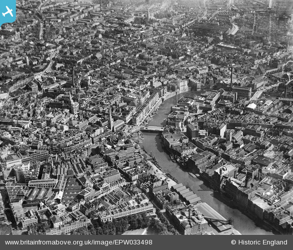
EPW033498 ENGLAND (1930). Bristol Bridge and the city, Bristol, 1930
© Copyright OpenStreetMap contributors and licensed by the OpenStreetMap Foundation. 2026. Cartography is licensed as CC BY-SA.
Nearby Images (30)
Details
| Title | [EPW033498] Bristol Bridge and the city, Bristol, 1930 |
| Reference | EPW033498 |
| Date | July-1930 |
| Link | |
| Place name | BRISTOL |
| Parish | |
| District | |
| Country | ENGLAND |
| Easting / Northing | 359014, 172948 |
| Longitude / Latitude | -2.5899273474664, 51.453539680138 |
| National Grid Reference | ST590729 |
Pins

Class31 |
Friday 21st of June 2013 07:41:57 AM | |

Class31 |
Friday 21st of June 2013 07:38:35 AM | |

Class31 |
Friday 21st of June 2013 07:35:53 AM | |

Class31 |
Tuesday 9th of April 2013 11:56:17 AM | |

Class31 |
Tuesday 9th of April 2013 11:53:47 AM | |

Class31 |
Tuesday 9th of April 2013 11:50:24 AM | |

Alan Marshall |
Thursday 17th of January 2013 12:45:56 PM | |

Alan Marshall |
Thursday 17th of January 2013 11:27:00 AM | |

Alan Marshall |
Friday 28th of December 2012 12:48:23 PM | |

MB |
Tuesday 25th of December 2012 10:57:09 PM | |

MB |
Tuesday 25th of December 2012 10:56:16 PM | |

MB |
Tuesday 25th of December 2012 10:54:48 PM | |

MB |
Tuesday 25th of December 2012 10:52:00 PM | |

MB |
Tuesday 25th of December 2012 10:46:56 PM | |
A 2007 view looking west towards the towers of the ruined St Peter's and St Mary-le-Port churches, showing Castle Park, which has replaced the streets here following German bombing in World War II: www.flickr.com/photos/brizzlebornandbred/2056350827/in/photostream/ |

MB |
Sunday 20th of January 2013 11:29:17 PM |

MB |
Tuesday 25th of December 2012 10:44:59 PM | |

MB |
Tuesday 25th of December 2012 10:43:45 PM | |

MB |
Tuesday 25th of December 2012 10:42:55 PM | |

MB |
Tuesday 25th of December 2012 10:41:32 PM | |

MB |
Tuesday 25th of December 2012 10:40:53 PM | |

MB |
Tuesday 25th of December 2012 10:40:18 PM | |

MB |
Tuesday 25th of December 2012 10:39:50 PM | |

MB |
Tuesday 25th of December 2012 10:39:09 PM | |

MB |
Tuesday 25th of December 2012 10:35:58 PM | |

MB |
Tuesday 25th of December 2012 10:35:35 PM | |

MB |
Tuesday 25th of December 2012 10:34:07 PM | |

Maurice |
Tuesday 25th of December 2012 05:45:10 PM |


![[EPW033498] Bristol Bridge and the city, Bristol, 1930](http://britainfromabove.org.uk/sites/all/libraries/aerofilms-images/public/100x100/EPW/033/EPW033498.jpg)
![[EPW038300] George's Brewery and Bristol Bridge, Bristol, 1932](http://britainfromabove.org.uk/sites/all/libraries/aerofilms-images/public/100x100/EPW/038/EPW038300.jpg)
![[EPW038303] Industry around the Bristol Bridge, Bristol, 1932](http://britainfromabove.org.uk/sites/all/libraries/aerofilms-images/public/100x100/EPW/038/EPW038303.jpg)
![[EPW038304] Victoria Street, George's Brewey and the W.B. Harris Print Works, Bristol, 1932](http://britainfromabove.org.uk/sites/all/libraries/aerofilms-images/public/100x100/EPW/038/EPW038304.jpg)
![[EAW032259] Victoria Street, the E. S. & A. Robinson Premises on Redcliff Street and environs, 1950. This image was marked by Aerofilms Ltd for photo editing.](http://britainfromabove.org.uk/sites/all/libraries/aerofilms-images/public/100x100/EAW/032/EAW032259.jpg)
![[EPW038302] Industry around the Bristol Bridge, Bristol, 1932](http://britainfromabove.org.uk/sites/all/libraries/aerofilms-images/public/100x100/EPW/038/EPW038302.jpg)
![[EPW038301] Industry around the Bristol Bridge, Bristol, 1932](http://britainfromabove.org.uk/sites/all/libraries/aerofilms-images/public/100x100/EPW/038/EPW038301.jpg)
![[EPR000072] Baldwin Street, Bristol Bridge and the city centre, Bristol, 1934](http://britainfromabove.org.uk/sites/all/libraries/aerofilms-images/public/100x100/EPR/000/EPR000072.jpg)
![[EAW032254] Victoria Street, the E. S. & A. Robinson Premises on Redcliff Street and environs, 1950. This image was marked by Aerofilms Ltd for photo editing.](http://britainfromabove.org.uk/sites/all/libraries/aerofilms-images/public/100x100/EAW/032/EAW032254.jpg)
![[EPW034455] Victoria Street and Works off Bath Street, Bristol, 1930](http://britainfromabove.org.uk/sites/all/libraries/aerofilms-images/public/100x100/EPW/034/EPW034455.jpg)
![[EAW032258] Victoria Street, the E. S. & A. Robinson Premises on Redcliff Street and environs, 1950. This image was marked by Aerofilms Ltd for photo editing.](http://britainfromabove.org.uk/sites/all/libraries/aerofilms-images/public/100x100/EAW/032/EAW032258.jpg)
![[EAW032257] Victoria Street, Redcliff Street and environs, Bristol, 1950. This image was marked by Aerofilms Ltd for photo editing.](http://britainfromabove.org.uk/sites/all/libraries/aerofilms-images/public/100x100/EAW/032/EAW032257.jpg)
![[EAW032256] Bath Street, Victoria Street and Redcliff Street, Bristol, 1950. This image was marked by Aerofilms Ltd for photo editing.](http://britainfromabove.org.uk/sites/all/libraries/aerofilms-images/public/100x100/EAW/032/EAW032256.jpg)
![[EPW034460] Bennett's Counterslip Works (Printing and Stationery) and the Tramway Generating Station, Bristol, 1930](http://britainfromabove.org.uk/sites/all/libraries/aerofilms-images/public/100x100/EPW/034/EPW034460.jpg)
![[EPW060117] The city centre, Bristol, 1938](http://britainfromabove.org.uk/sites/all/libraries/aerofilms-images/public/100x100/EPW/060/EPW060117.jpg)
![[EPW034451] Tramway Generating Station at Philip Street and the area around St Philip's Bridge and Bristol Bridge, Bristol, 1930](http://britainfromabove.org.uk/sites/all/libraries/aerofilms-images/public/100x100/EPW/034/EPW034451.jpg)
![[EPW034452] George's Brewey, the Tramway Generating Station and Victoria Street, Bristol, 1930](http://britainfromabove.org.uk/sites/all/libraries/aerofilms-images/public/100x100/EPW/034/EPW034452.jpg)
![[EPW034458] Victoria Street and Temple Street and environs, Bristol, 1930](http://britainfromabove.org.uk/sites/all/libraries/aerofilms-images/public/100x100/EPW/034/EPW034458.jpg)
![[EAW032261] Redcliff Street, the Church of St Thomas the Martyr and environs, Bristol, 1950. This image was marked by Aerofilms Ltd for photo editing.](http://britainfromabove.org.uk/sites/all/libraries/aerofilms-images/public/100x100/EAW/032/EAW032261.jpg)
![[EPW034459] Bennett's Counterslip Works (Printing and Stationery) and the Tramway Generating Station, Bristol, 1930](http://britainfromabove.org.uk/sites/all/libraries/aerofilms-images/public/100x100/EPW/034/EPW034459.jpg)
![[EPW034454] George's Brewery, Bennett's Counterslip Works (Print and Stationey) and the Tramway Generating Station, Bristol, 1930](http://britainfromabove.org.uk/sites/all/libraries/aerofilms-images/public/100x100/EPW/034/EPW034454.jpg)
![[EAW032260] Victoria Street, Redcliff Street and Bristol Bridge, Bristol, 1950. This image was marked by Aerofilms Ltd for photo editing.](http://britainfromabove.org.uk/sites/all/libraries/aerofilms-images/public/100x100/EAW/032/EAW032260.jpg)
![[EPW034453] George's Brewey, the Tramway Generating Station and Temple Street, Bristol, 1930](http://britainfromabove.org.uk/sites/all/libraries/aerofilms-images/public/100x100/EPW/034/EPW034453.jpg)
![[EPW047089] St Nicholas's Church, Colston Avenue and Baldwin Street, Bristol, 1935](http://britainfromabove.org.uk/sites/all/libraries/aerofilms-images/public/100x100/EPW/047/EPW047089.jpg)
![[EAW032255] Victoria Street, Redcliff Street and Bristol Bridge, Bristol, 1950. This image was marked by Aerofilms Ltd for photo editing.](http://britainfromabove.org.uk/sites/all/libraries/aerofilms-images/public/100x100/EAW/032/EAW032255.jpg)
![[EPW034450] Tramway Generating Station at Philip Street and the area around St Philip's Bridge and Bristol Bridge, Bristol, 1930](http://britainfromabove.org.uk/sites/all/libraries/aerofilms-images/public/100x100/EPW/034/EPW034450.jpg)
![[EPW034456] Tramway Generating Station at Philip Street and the area around St Philip's Bridge and Bristol Bridge, Bristol, 1930](http://britainfromabove.org.uk/sites/all/libraries/aerofilms-images/public/100x100/EPW/034/EPW034456.jpg)
![[EAW026794] The city centre, Bristol, from the south-west, 1949](http://britainfromabove.org.uk/sites/all/libraries/aerofilms-images/public/100x100/EAW/026/EAW026794.jpg)
![[EPW060118] The city centre, Bristol, 1938](http://britainfromabove.org.uk/sites/all/libraries/aerofilms-images/public/100x100/EPW/060/EPW060118.jpg)
![[EPR000085] Queen Square and the city centre, Bristol, 1934](http://britainfromabove.org.uk/sites/all/libraries/aerofilms-images/public/100x100/EPR/000/EPR000085.jpg)


