
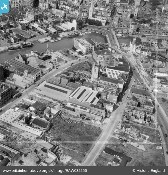
EAW032255 ENGLAND (1950). Victoria Street, Redcliff Street and Bristol Bridge, Bristol, 1950. This image was marked by Aerofilms Ltd for photo editing.
© Copyright OpenStreetMap contributors and licensed by the OpenStreetMap Foundation. 2026. Cartography is licensed as CC BY-SA.
Nearby Images (33)
EAW032255

EAW032260

EAW032261

EAW032258

EAW032254

EAW032256

EAW032257

EAW032259

EPW008821

EPW008826

EPW008825

EPW008823

EPW034455

EPW008822

EPW038304

EPW008826A

EPW034452

EPW038303

EPW008819

EPW008820

EPW034458

EPW034460
 and the Tramway Generating Station, Bristol, 1930")
EPW038302

EPW038301

EPW038300

EPW034453

EPW008824

EPW034459
 and the Tramway Generating Station, Bristol, 1930")
EPW034457

EPW034454
 and the Tramway Generating Station, Bristol, 1930")
EPW033498

EAW026795

EPR000072

Details
| Title | [EAW032255] Victoria Street, Redcliff Street and Bristol Bridge, Bristol, 1950. This image was marked by Aerofilms Ltd for photo editing. |
| Reference | EAW032255 |
| Date | 5-September-1950 |
| Link | |
| Place name | BRISTOL |
| Parish | |
| District | |
| Country | ENGLAND |
| Easting / Northing | 359104, 172734 |
| Longitude / Latitude | -2.58860726889, 51.451621879703 |
| National Grid Reference | ST591727 |
Pins

Class31 |
Monday 1st of December 2014 03:16:42 PM | |

Braikenridge |
Tuesday 22nd of April 2014 06:25:24 PM |

User Comment Contributions
Bristol Bridge, 06/08/2013 |
Class31 |
Monday 1st of December 2014 03:19:03 PM |