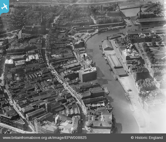
EPW008825 ENGLAND (1923). Redcliffe Wharf, Bristol, 1923
© Copyright OpenStreetMap contributors and licensed by the OpenStreetMap Foundation. 2026. Cartography is licensed as CC BY-SA.
Nearby Images (23)
Details
| Title | [EPW008825] Redcliffe Wharf, Bristol, 1923 |
| Reference | EPW008825 |
| Date | 1923 |
| Link | |
| Place name | BRISTOL |
| Parish | |
| District | |
| Country | ENGLAND |
| Easting / Northing | 359007, 172627 |
| Longitude / Latitude | -2.5899908874042, 51.450652708009 |
| National Grid Reference | ST590726 |
Pins
Be the first to add a comment to this image!


![[EPW008825] Redcliffe Wharf, Bristol, 1923](http://britainfromabove.org.uk/sites/all/libraries/aerofilms-images/public/100x100/EPW/008/EPW008825.jpg)
![[EPW008826] Redcliffe Wharf and Queen Square, Bristol, 1923](http://britainfromabove.org.uk/sites/all/libraries/aerofilms-images/public/100x100/EPW/008/EPW008826.jpg)
![[EPW008823] Redcliffe Wharf, Bristol, 1923](http://britainfromabove.org.uk/sites/all/libraries/aerofilms-images/public/100x100/EPW/008/EPW008823.jpg)
![[EPW008826A] Redcliffe Wharf, Bristol, 1923](http://britainfromabove.org.uk/sites/all/libraries/aerofilms-images/public/100x100/EPW/008/EPW008826A.jpg)
![[EPW008819] Redcliffe Wharf, Bristol, 1923](http://britainfromabove.org.uk/sites/all/libraries/aerofilms-images/public/100x100/EPW/008/EPW008819.jpg)
![[EPW008822] Redcliffe Wharf and Queen Square, Bristol, 1923](http://britainfromabove.org.uk/sites/all/libraries/aerofilms-images/public/100x100/EPW/008/EPW008822.jpg)
![[EPW008821] Redcliffe Wharf and Queen Square, Bristol, 1923](http://britainfromabove.org.uk/sites/all/libraries/aerofilms-images/public/100x100/EPW/008/EPW008821.jpg)
![[EPW008820] Redcliffe Wharf and Queen Square, Bristol, 1923](http://britainfromabove.org.uk/sites/all/libraries/aerofilms-images/public/100x100/EPW/008/EPW008820.jpg)
![[EPW008824] Redcliffe Wharf, Bristol, 1923](http://britainfromabove.org.uk/sites/all/libraries/aerofilms-images/public/100x100/EPW/008/EPW008824.jpg)
![[EAW032261] Redcliff Street, the Church of St Thomas the Martyr and environs, Bristol, 1950. This image was marked by Aerofilms Ltd for photo editing.](http://britainfromabove.org.uk/sites/all/libraries/aerofilms-images/public/100x100/EAW/032/EAW032261.jpg)
![[EAW032260] Victoria Street, Redcliff Street and Bristol Bridge, Bristol, 1950. This image was marked by Aerofilms Ltd for photo editing.](http://britainfromabove.org.uk/sites/all/libraries/aerofilms-images/public/100x100/EAW/032/EAW032260.jpg)
![[EAW026795] Queen Square and the city centre, Bristol, from the south-west, 1949](http://britainfromabove.org.uk/sites/all/libraries/aerofilms-images/public/100x100/EAW/026/EAW026795.jpg)
![[EAW032255] Victoria Street, Redcliff Street and Bristol Bridge, Bristol, 1950. This image was marked by Aerofilms Ltd for photo editing.](http://britainfromabove.org.uk/sites/all/libraries/aerofilms-images/public/100x100/EAW/032/EAW032255.jpg)
![[EAW032258] Victoria Street, the E. S. & A. Robinson Premises on Redcliff Street and environs, 1950. This image was marked by Aerofilms Ltd for photo editing.](http://britainfromabove.org.uk/sites/all/libraries/aerofilms-images/public/100x100/EAW/032/EAW032258.jpg)
![[EAW032254] Victoria Street, the E. S. & A. Robinson Premises on Redcliff Street and environs, 1950. This image was marked by Aerofilms Ltd for photo editing.](http://britainfromabove.org.uk/sites/all/libraries/aerofilms-images/public/100x100/EAW/032/EAW032254.jpg)
![[EAW032257] Victoria Street, Redcliff Street and environs, Bristol, 1950. This image was marked by Aerofilms Ltd for photo editing.](http://britainfromabove.org.uk/sites/all/libraries/aerofilms-images/public/100x100/EAW/032/EAW032257.jpg)
![[EAW032259] Victoria Street, the E. S. & A. Robinson Premises on Redcliff Street and environs, 1950. This image was marked by Aerofilms Ltd for photo editing.](http://britainfromabove.org.uk/sites/all/libraries/aerofilms-images/public/100x100/EAW/032/EAW032259.jpg)
![[EAW032256] Bath Street, Victoria Street and Redcliff Street, Bristol, 1950. This image was marked by Aerofilms Ltd for photo editing.](http://britainfromabove.org.uk/sites/all/libraries/aerofilms-images/public/100x100/EAW/032/EAW032256.jpg)
![[EPR000085] Queen Square and the city centre, Bristol, 1934](http://britainfromabove.org.uk/sites/all/libraries/aerofilms-images/public/100x100/EPR/000/EPR000085.jpg)
![[EAW000738] Redcliffe Bridge, the Church of St Mary Redcliff and the city, Bristol, from the south-east, 1946](http://britainfromabove.org.uk/sites/all/libraries/aerofilms-images/public/100x100/EAW/000/EAW000738.jpg)
![[EAW000739] The Church of St Mary Redcliff and environs, Bristol, 1946](http://britainfromabove.org.uk/sites/all/libraries/aerofilms-images/public/100x100/EAW/000/EAW000739.jpg)
![[EAW026794] The city centre, Bristol, from the south-west, 1949](http://britainfromabove.org.uk/sites/all/libraries/aerofilms-images/public/100x100/EAW/026/EAW026794.jpg)
![[EPW034452] George's Brewey, the Tramway Generating Station and Victoria Street, Bristol, 1930](http://britainfromabove.org.uk/sites/all/libraries/aerofilms-images/public/100x100/EPW/034/EPW034452.jpg)