
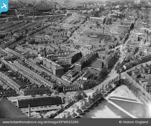
EPW015280 ENGLAND (1926). The Leicester Royal Infirmary and environs, Leicester, 1926
© Copyright OpenStreetMap contributors and licensed by the OpenStreetMap Foundation. 2026. Cartography is licensed as CC BY-SA.
Nearby Images (6)
EPW015280

EPW015279

EPW015282

EPW015281

EAW051829

EPW018426

Details
| Title | [EPW015280] The Leicester Royal Infirmary and environs, Leicester, 1926 |
| Reference | EPW015280 |
| Date | 20-April-1926 |
| Link | |
| Place name | LEICESTER |
| Parish | |
| District | |
| Country | ENGLAND |
| Easting / Northing | 458659, 303616 |
| Longitude / Latitude | -1.1332947621417, 52.626777973567 |
| National Grid Reference | SK587036 |
Pins

Underwood55 |
Tuesday 15th of October 2013 11:38:13 PM | |
|
Underwood55 |
Tuesday 11th of December 2012 08:25:00 PM | |
|
deeb |
Sunday 9th of December 2012 01:55:13 PM | |
|
deeb |
Sunday 9th of December 2012 01:52:58 PM |
User Comment Contributions
The road nearest the bottom, running broadly left to right is Aylestone Road. On the far right is the prison. The road branching upwards from Aylestone Road on the extreme left is Napier Street. To its right is Aylestone Street, followed by Knighton Street. All three of these are now beneath the hospital. |
Septercius |
Tuesday 28th of August 2012 10:13:27 PM |