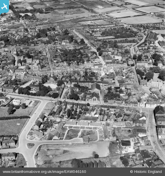
EAW046160 ENGLAND (1952). Holydyke and the town, Barton-Upon-Humber, 1952
© Copyright OpenStreetMap contributors and licensed by the OpenStreetMap Foundation. 2026. Cartography is licensed as CC BY-SA.
Nearby Images (19)
Details
| Title | [EAW046160] Holydyke and the town, Barton-Upon-Humber, 1952 |
| Reference | EAW046160 |
| Date | 22-August-1952 |
| Link | |
| Place name | BARTON-UPON-HUMBER |
| Parish | BARTON-UPON-HUMBER |
| District | |
| Country | ENGLAND |
| Easting / Northing | 503062, 421998 |
| Longitude / Latitude | -0.43930865987626, 53.684030975858 |
| National Grid Reference | TA031220 |
Pins

gBr |
Tuesday 2nd of February 2016 07:08:27 PM | |

Bartonian |
Thursday 6th of November 2014 12:48:13 AM | |

Bartonian |
Thursday 6th of November 2014 12:47:16 AM | |

Bartonian |
Thursday 6th of November 2014 12:46:10 AM | |

Bartonian |
Thursday 6th of November 2014 12:45:09 AM | |

Bartonian |
Thursday 6th of November 2014 12:44:30 AM | |

Bartonian |
Thursday 6th of November 2014 12:43:19 AM | |

Bartonian |
Thursday 6th of November 2014 12:39:33 AM | |

Bartonian |
Thursday 6th of November 2014 12:38:15 AM | |

Bartonian |
Thursday 6th of November 2014 12:36:44 AM | |

Bartonian |
Thursday 6th of November 2014 12:35:43 AM |


![[EAW046160] Holydyke and the town, Barton-Upon-Humber, 1952](http://britainfromabove.org.uk/sites/all/libraries/aerofilms-images/public/100x100/EAW/046/EAW046160.jpg)
![[EPW012679] Trinity Methodist Church and environs, Barton-upon-Humber, 1925](http://britainfromabove.org.uk/sites/all/libraries/aerofilms-images/public/100x100/EPW/012/EPW012679.jpg)
![[EAW031244] The town, Barton-Upon-Humber, 1950](http://britainfromabove.org.uk/sites/all/libraries/aerofilms-images/public/100x100/EAW/031/EAW031244.jpg)
![[EAW046050] The Elswick Hopper Cycle Works off Castledykes South and the town centre, Barton-Upon-Humber, 1952. This image was marked by Aerofilms Ltd for photo editing.](http://britainfromabove.org.uk/sites/all/libraries/aerofilms-images/public/100x100/EAW/046/EAW046050.jpg)
![[EAW046052] The Elswick Hopper Cycle Works off Castledykes South and the town centre, Barton-Upon-Humber, 1952. This image was marked by Aerofilms Ltd for photo editing.](http://britainfromabove.org.uk/sites/all/libraries/aerofilms-images/public/100x100/EAW/046/EAW046052.jpg)
![[EPW046232] The town and surrounding countryside, Barton-upon-Humber, from the west, 1934](http://britainfromabove.org.uk/sites/all/libraries/aerofilms-images/public/100x100/EPW/046/EPW046232.jpg)
![[EAW046049] The Elswick Hopper Cycle Works off Castledykes South and the town centre, Barton-Upon-Humber, 1952. This image was marked by Aerofilms Ltd for photo editing.](http://britainfromabove.org.uk/sites/all/libraries/aerofilms-images/public/100x100/EAW/046/EAW046049.jpg)
![[EPW046229] The town and the River Humber, Barton-upon-Humber, from the south-west, 1934. This image has been produced from a damaged negative.](http://britainfromabove.org.uk/sites/all/libraries/aerofilms-images/public/100x100/EPW/046/EPW046229.jpg)
![[EAW046054] The Elswick Hopper Cycle Works off Castledykes South and the town centre, Barton-Upon-Humber, 1952. This image was marked by Aerofilms Ltd for photo editing.](http://britainfromabove.org.uk/sites/all/libraries/aerofilms-images/public/100x100/EAW/046/EAW046054.jpg)
![[EAW046053] The Elswick Hopper Cycle Works off Castledykes South and the town centre, Barton-Upon-Humber, 1952. This image was marked by Aerofilms Ltd for photo editing.](http://britainfromabove.org.uk/sites/all/libraries/aerofilms-images/public/100x100/EAW/046/EAW046053.jpg)
![[EAW046055] The Elswick Hopper Cycle Works off Castledykes South, Barton-Upon-Humber, 1952. This image was marked by Aerofilms Ltd for photo editing.](http://britainfromabove.org.uk/sites/all/libraries/aerofilms-images/public/100x100/EAW/046/EAW046055.jpg)
![[EPW046225] The Elswick-Hopper Cycle Co Works and the town centre, Barton-upon-Humber, 1934](http://britainfromabove.org.uk/sites/all/libraries/aerofilms-images/public/100x100/EPW/046/EPW046225.jpg)
![[EPW046226] The Elswick-Hopper Cycle Co Works and the town centre, Barton-upon-Humber, 1934](http://britainfromabove.org.uk/sites/all/libraries/aerofilms-images/public/100x100/EPW/046/EPW046226.jpg)
![[EAW046159] The town, Barton-Upon-Humber, 1952](http://britainfromabove.org.uk/sites/all/libraries/aerofilms-images/public/100x100/EAW/046/EAW046159.jpg)
![[EPW046227] The Elswick-Hopper Cycle Co Works and the town centre, Barton-upon-Humber, 1934](http://britainfromabove.org.uk/sites/all/libraries/aerofilms-images/public/100x100/EPW/046/EPW046227.jpg)
![[EPW046221] St Mary's Cycle Works and St Mary's Church, Barton-upon-Humber, 1934. This image has been produced from a damaged negative.](http://britainfromabove.org.uk/sites/all/libraries/aerofilms-images/public/100x100/EPW/046/EPW046221.jpg)
![[EPW046222] The Elswick-Hopper Cycle Co Works, Baysgarth Park and the town centre, Barton-upon-Humber, 1934](http://britainfromabove.org.uk/sites/all/libraries/aerofilms-images/public/100x100/EPW/046/EPW046222.jpg)
![[EAW046161] St Mary's Cycle Works and the town, Barton-Upon-Humber, 1952](http://britainfromabove.org.uk/sites/all/libraries/aerofilms-images/public/100x100/EAW/046/EAW046161.jpg)
![[EAW046041] St Mary's Church alongside St Mary's Cycle Works (Elswick Hopper), Barton-Upon-Humber, 1952. This image was marked by Aerofilms Ltd for photo editing.](http://britainfromabove.org.uk/sites/all/libraries/aerofilms-images/public/100x100/EAW/046/EAW046041.jpg)