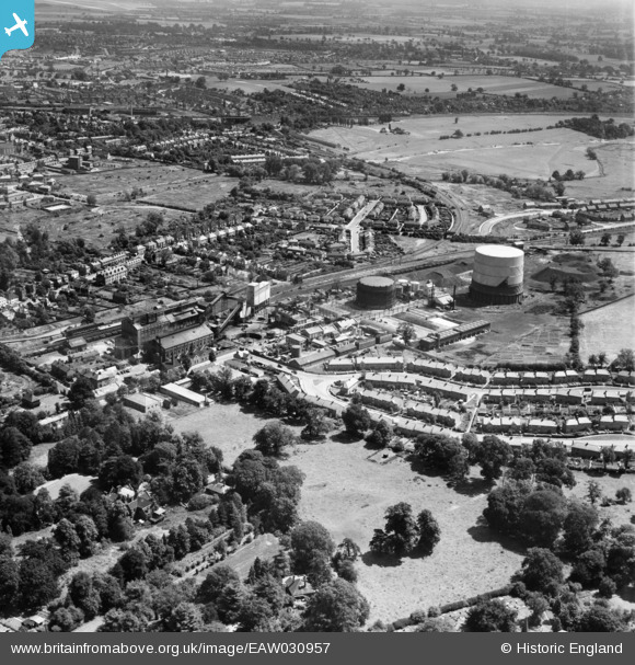
EAW030957 ENGLAND (1950). The Gas Works, St Albans, 1950
© Copyright OpenStreetMap contributors and licensed by the OpenStreetMap Foundation. 2026. Cartography is licensed as CC BY-SA.
Nearby Images (17)
Details
| Title | [EAW030957] The Gas Works, St Albans, 1950 |
| Reference | EAW030957 |
| Date | 13-July-1950 |
| Link | |
| Place name | ST ALBANS |
| Parish | |
| District | |
| Country | ENGLAND |
| Easting / Northing | 514599, 206217 |
| Longitude / Latitude | -0.33998490850943, 51.742466586017 |
| National Grid Reference | TL146062 |
Pins

John W |
Friday 8th of July 2016 06:24:39 PM | |

John W |
Friday 8th of July 2016 06:23:15 PM | |

John W |
Friday 8th of July 2016 06:22:22 PM | |

John W |
Friday 8th of July 2016 06:21:16 PM | |

John W |
Friday 8th of July 2016 06:20:16 PM | |

John W |
Friday 8th of July 2016 06:10:59 PM | |

John W |
Friday 8th of July 2016 06:06:00 PM | |

John W |
Friday 8th of July 2016 06:05:28 PM | |

John W |
Friday 8th of July 2016 06:04:23 PM |
User Comment Contributions
The Gasworks closed in 1971, with the advent of North Sea gas. The whole area is now occupied by retail units and office blocks. |

John W |
Friday 8th of July 2016 06:25:52 PM |


![[EAW030957] The Gas Works, St Albans, 1950](http://britainfromabove.org.uk/sites/all/libraries/aerofilms-images/public/100x100/EAW/030/EAW030957.jpg)
![[EAW030958] The Gas Works, St Albans, 1950](http://britainfromabove.org.uk/sites/all/libraries/aerofilms-images/public/100x100/EAW/030/EAW030958.jpg)
![[EAW030237] The gas works and city, St Albans, 1950](http://britainfromabove.org.uk/sites/all/libraries/aerofilms-images/public/100x100/EAW/030/EAW030237.jpg)
![[EAW030949] Doggett's Way, the Gas Works and the city, St Albans, from the south, 1950](http://britainfromabove.org.uk/sites/all/libraries/aerofilms-images/public/100x100/EAW/030/EAW030949.jpg)
![[EAW030950] The Gas Works and the city, St Albans, from the south-west, 1950](http://britainfromabove.org.uk/sites/all/libraries/aerofilms-images/public/100x100/EAW/030/EAW030950.jpg)
![[EAW030956] The Gas Works, St Albans, 1950](http://britainfromabove.org.uk/sites/all/libraries/aerofilms-images/public/100x100/EAW/030/EAW030956.jpg)
![[EPW016807] Gas works and St Albans Abbey Station, St Albans, 1926](http://britainfromabove.org.uk/sites/all/libraries/aerofilms-images/public/100x100/EPW/016/EPW016807.jpg)
![[EAW030947] The Gas Works and the city, St Albans, from the south, 1950](http://britainfromabove.org.uk/sites/all/libraries/aerofilms-images/public/100x100/EAW/030/EAW030947.jpg)
![[EPW061043] The Thomas Mercer Marine Chronometer Works on Eywood Road, St Albans, 1939](http://britainfromabove.org.uk/sites/all/libraries/aerofilms-images/public/100x100/EPW/061/EPW061043.jpg)
![[EPW061045] The Thomas Mercer Marine Chronometer Works on Eywood Road, St Albans, 1939](http://britainfromabove.org.uk/sites/all/libraries/aerofilms-images/public/100x100/EPW/061/EPW061045.jpg)
![[EPW061046] The Thomas Mercer Marine Chronometer Works on Eywood Road, St Albans, 1939](http://britainfromabove.org.uk/sites/all/libraries/aerofilms-images/public/100x100/EPW/061/EPW061046.jpg)
![[EPW061042] The Thomas Mercer Marine Chronometer Works on Eywood Road, St Albans, 1939](http://britainfromabove.org.uk/sites/all/libraries/aerofilms-images/public/100x100/EPW/061/EPW061042.jpg)
![[EPW061044] The Thomas Mercer Marine Chronometer Works on Eywood Road, St Albans, 1939](http://britainfromabove.org.uk/sites/all/libraries/aerofilms-images/public/100x100/EPW/061/EPW061044.jpg)
![[EAW030232] St Julian's and the city, St Albans, 1950](http://britainfromabove.org.uk/sites/all/libraries/aerofilms-images/public/100x100/EAW/030/EAW030232.jpg)
![[EAW030236] The gas works and city, St Albans, 1950](http://britainfromabove.org.uk/sites/all/libraries/aerofilms-images/public/100x100/EAW/030/EAW030236.jpg)
![[EAW030959] The Gas Works and Abbey Station, St Albans, from the north, 1950](http://britainfromabove.org.uk/sites/all/libraries/aerofilms-images/public/100x100/EAW/030/EAW030959.jpg)
![[EAW030240] The gas works, St Albans, from the north-west, 1950. This image was marked by Aerofilms Ltd for photo editing.](http://britainfromabove.org.uk/sites/all/libraries/aerofilms-images/public/100x100/EAW/030/EAW030240.jpg)