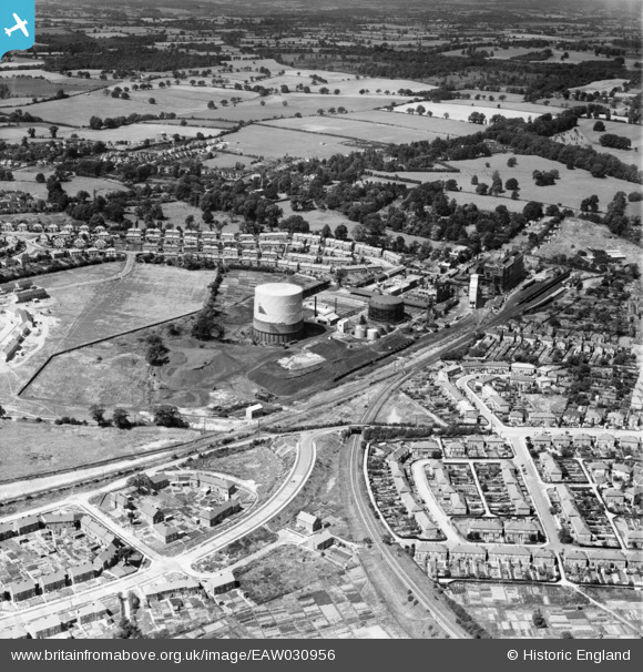
EAW030956 ENGLAND (1950). The Gas Works, St Albans, 1950
© Copyright OpenStreetMap contributors and licensed by the OpenStreetMap Foundation. 2026. Cartography is licensed as CC BY-SA.
Nearby Images (17)
Details
| Title | [EAW030956] The Gas Works, St Albans, 1950 |
| Reference | EAW030956 |
| Date | 13-July-1950 |
| Link | |
| Place name | ST ALBANS |
| Parish | |
| District | |
| Country | ENGLAND |
| Easting / Northing | 514671, 206129 |
| Longitude / Latitude | -0.33897144334401, 51.741660878973 |
| National Grid Reference | TL147061 |


![[EAW030956] The Gas Works, St Albans, 1950](http://britainfromabove.org.uk/sites/all/libraries/aerofilms-images/public/100x100/EAW/030/EAW030956.jpg)
![[EAW030237] The gas works and city, St Albans, 1950](http://britainfromabove.org.uk/sites/all/libraries/aerofilms-images/public/100x100/EAW/030/EAW030237.jpg)
![[EAW030947] The Gas Works and the city, St Albans, from the south, 1950](http://britainfromabove.org.uk/sites/all/libraries/aerofilms-images/public/100x100/EAW/030/EAW030947.jpg)
![[EAW030957] The Gas Works, St Albans, 1950](http://britainfromabove.org.uk/sites/all/libraries/aerofilms-images/public/100x100/EAW/030/EAW030957.jpg)
![[EAW030232] St Julian's and the city, St Albans, 1950](http://britainfromabove.org.uk/sites/all/libraries/aerofilms-images/public/100x100/EAW/030/EAW030232.jpg)
![[EAW030958] The Gas Works, St Albans, 1950](http://britainfromabove.org.uk/sites/all/libraries/aerofilms-images/public/100x100/EAW/030/EAW030958.jpg)
![[EAW030236] The gas works and city, St Albans, 1950](http://britainfromabove.org.uk/sites/all/libraries/aerofilms-images/public/100x100/EAW/030/EAW030236.jpg)
![[EAW030950] The Gas Works and the city, St Albans, from the south-west, 1950](http://britainfromabove.org.uk/sites/all/libraries/aerofilms-images/public/100x100/EAW/030/EAW030950.jpg)
![[EAW030949] Doggett's Way, the Gas Works and the city, St Albans, from the south, 1950](http://britainfromabove.org.uk/sites/all/libraries/aerofilms-images/public/100x100/EAW/030/EAW030949.jpg)
![[EAW030946] The Gas Works, construction of new housing at Pemberton Close and the city, St Albans, from the south, 1950](http://britainfromabove.org.uk/sites/all/libraries/aerofilms-images/public/100x100/EAW/030/EAW030946.jpg)
![[EPW016807] Gas works and St Albans Abbey Station, St Albans, 1926](http://britainfromabove.org.uk/sites/all/libraries/aerofilms-images/public/100x100/EPW/016/EPW016807.jpg)
![[EAW030951] The Gas Works, Abbey Station and Verulamium Park, St Albans, from the south-east, 1950](http://britainfromabove.org.uk/sites/all/libraries/aerofilms-images/public/100x100/EAW/030/EAW030951.jpg)
![[EPW061045] The Thomas Mercer Marine Chronometer Works on Eywood Road, St Albans, 1939](http://britainfromabove.org.uk/sites/all/libraries/aerofilms-images/public/100x100/EPW/061/EPW061045.jpg)
![[EPW061046] The Thomas Mercer Marine Chronometer Works on Eywood Road, St Albans, 1939](http://britainfromabove.org.uk/sites/all/libraries/aerofilms-images/public/100x100/EPW/061/EPW061046.jpg)
![[EPW061043] The Thomas Mercer Marine Chronometer Works on Eywood Road, St Albans, 1939](http://britainfromabove.org.uk/sites/all/libraries/aerofilms-images/public/100x100/EPW/061/EPW061043.jpg)
![[EPW061042] The Thomas Mercer Marine Chronometer Works on Eywood Road, St Albans, 1939](http://britainfromabove.org.uk/sites/all/libraries/aerofilms-images/public/100x100/EPW/061/EPW061042.jpg)
![[EPW061044] The Thomas Mercer Marine Chronometer Works on Eywood Road, St Albans, 1939](http://britainfromabove.org.uk/sites/all/libraries/aerofilms-images/public/100x100/EPW/061/EPW061044.jpg)

