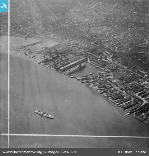
EAW029270 ENGLAND (1950). Cammell Laird and Co Ltd Shipbuilding and Engineering Works and environs, Birkenhead, 1950. This image was marked by Aerofilms Ltd for photo editing.
© Copyright OpenStreetMap contributors and licensed by the OpenStreetMap Foundation. 2026. Cartography is licensed as CC BY-SA.
Nearby Images (19)
Details
| Title | [EAW029270] Cammell Laird and Co Ltd Shipbuilding and Engineering Works and environs, Birkenhead, 1950. This image was marked by Aerofilms Ltd for photo editing. |
| Reference | EAW029270 |
| Date | 11-May-1950 |
| Link | |
| Place name | BIRKENHEAD |
| Parish | |
| District | |
| Country | ENGLAND |
| Easting / Northing | 333054, 388136 |
| Longitude / Latitude | -3.0066521024338, 53.385556251071 |
| National Grid Reference | SJ331881 |


![[EAW029270] Cammell Laird and Co Ltd Shipbuilding and Engineering Works and environs, Birkenhead, 1950. This image was marked by Aerofilms Ltd for photo editing.](http://britainfromabove.org.uk/sites/all/libraries/aerofilms-images/public/100x100/EAW/029/EAW029270.jpg)
![[EAW029264] Cammell Laird and Co Ltd Shipbuilding and Engineering Works and the Graving Docks to the north of the Outer Basin, Birkenhead, 1950. This image was marked by Aerofilms Ltd for photo editing.](http://britainfromabove.org.uk/sites/all/libraries/aerofilms-images/public/100x100/EAW/029/EAW029264.jpg)
![[EAW030649] The Cammell Laird Shipbuilding and Engineering Works, Birkenhead, 1950](http://britainfromabove.org.uk/sites/all/libraries/aerofilms-images/public/100x100/EAW/030/EAW030649.jpg)
![[EAW029266] Cammell Laird and Co Ltd Shipbuilding and Engineering Works and environs, Birkenhead, 1950](http://britainfromabove.org.uk/sites/all/libraries/aerofilms-images/public/100x100/EAW/029/EAW029266.jpg)
![[EAW030647] The Cammell Laird Shipbuilding and Engineering Works, Birkenhead, 1950](http://britainfromabove.org.uk/sites/all/libraries/aerofilms-images/public/100x100/EAW/030/EAW030647.jpg)
![[EAW051422] Cammell Laird's Shipbuilding and Engineering Works and environs, Birkenhead, 1953](http://britainfromabove.org.uk/sites/all/libraries/aerofilms-images/public/100x100/EAW/051/EAW051422.jpg)
![[EAW030641] The Cammell Laird Shipbuilding and Engineering Works, Birkenhead, 1950](http://britainfromabove.org.uk/sites/all/libraries/aerofilms-images/public/100x100/EAW/030/EAW030641.jpg)
![[EAW029265] Cammell Laird and Co Ltd Shipbuilding and Engineering Works and the Graving Docks to the north of the Outer Basin, Birkenhead, 1950. This image was marked by Aerofilms Ltd for photo editing.](http://britainfromabove.org.uk/sites/all/libraries/aerofilms-images/public/100x100/EAW/029/EAW029265.jpg)
![[EAW029269] Cammell Laird and Co Ltd Shipbuilding and Engineering Works and environs, Birkenhead, 1950. This image was marked by Aerofilms Ltd for photo editing.](http://britainfromabove.org.uk/sites/all/libraries/aerofilms-images/public/100x100/EAW/029/EAW029269.jpg)
![[EAW028439] Cammell Laird's Shipbuilding and Engineering Works and King's Square, Birkenhead, 1950](http://britainfromabove.org.uk/sites/all/libraries/aerofilms-images/public/100x100/EAW/028/EAW028439.jpg)
![[EAW030648] The Cammell Laird Shipbuilding and Engineering Works, Birkenhead, 1950](http://britainfromabove.org.uk/sites/all/libraries/aerofilms-images/public/100x100/EAW/030/EAW030648.jpg)
![[EAW030640] The Cammell Laird Shipbuilding and Engineering Works, Birkenhead, 1950](http://britainfromabove.org.uk/sites/all/libraries/aerofilms-images/public/100x100/EAW/030/EAW030640.jpg)
![[EAW029267] Cammell Laird and Co Ltd Shipbuilding and Engineering Works and environs, Birkenhead, 1950](http://britainfromabove.org.uk/sites/all/libraries/aerofilms-images/public/100x100/EAW/029/EAW029267.jpg)
![[EAW029263] Cammell Laird and Co Ltd Shipbuilding and Engineering Works, Birkenhead, 1950](http://britainfromabove.org.uk/sites/all/libraries/aerofilms-images/public/100x100/EAW/029/EAW029263.jpg)
![[EAW001718] Outer Basin and Graving Docks of Cammell Laird's Shipbuilders Ltd, Birkenhead, 1946](http://britainfromabove.org.uk/sites/all/libraries/aerofilms-images/public/100x100/EAW/001/EAW001718.jpg)
![[EAW030639] The Cammell Laird Shipbuilding and Engineering Works, Birkenhead, 1950](http://britainfromabove.org.uk/sites/all/libraries/aerofilms-images/public/100x100/EAW/030/EAW030639.jpg)
![[EAW030637] The Cammell Laird Shipbuilding and Engineering Works, Birkenhead, 1950](http://britainfromabove.org.uk/sites/all/libraries/aerofilms-images/public/100x100/EAW/030/EAW030637.jpg)
![[EAW030638] The Cammell Laird Shipbuilding and Engineering Works, Birkenhead, 1950](http://britainfromabove.org.uk/sites/all/libraries/aerofilms-images/public/100x100/EAW/030/EAW030638.jpg)
![[EAW030646] The Cammell Laird Shipbuilding and Engineering Works, Birkenhead, 1950](http://britainfromabove.org.uk/sites/all/libraries/aerofilms-images/public/100x100/EAW/030/EAW030646.jpg)
