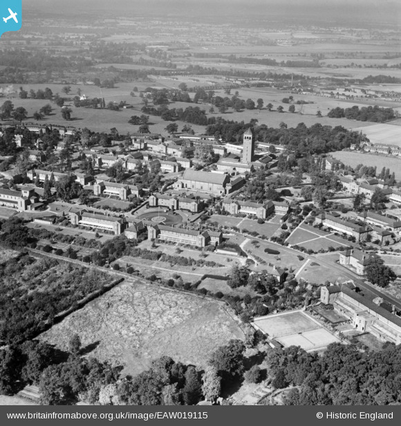
EAW019115 ENGLAND (1948). Shenley Hospital, Shenley, 1948
© Copyright OpenStreetMap contributors and licensed by the OpenStreetMap Foundation. 2026. Cartography is licensed as CC BY-SA.
Nearby Images (35)
Details
| Title | [EAW019115] Shenley Hospital, Shenley, 1948 |
| Reference | EAW019115 |
| Date | 30-September-1948 |
| Link | |
| Place name | SHENLEY |
| Parish | SHENLEY |
| District | |
| Country | ENGLAND |
| Easting / Northing | 518311, 200866 |
| Longitude / Latitude | -0.28805814408389, 51.693599430001 |
| National Grid Reference | TL183009 |
Pins

Matt Aldred edob.mattaldred.com |
Sunday 19th of September 2021 05:27:16 PM | |

Matt Aldred edob.mattaldred.com |
Sunday 19th of September 2021 05:27:00 PM | |

Matt Aldred edob.mattaldred.com |
Sunday 19th of September 2021 05:26:54 PM | |

Matt Aldred edob.mattaldred.com |
Sunday 19th of September 2021 05:26:40 PM | |

Matt Aldred edob.mattaldred.com |
Sunday 19th of September 2021 05:26:33 PM |


![[EAW019115] Shenley Hospital, Shenley, 1948](http://britainfromabove.org.uk/sites/all/libraries/aerofilms-images/public/100x100/EAW/019/EAW019115.jpg)
![[EPW043667] Shenley Mental Hospital, Shenley, 1933](http://britainfromabove.org.uk/sites/all/libraries/aerofilms-images/public/100x100/EPW/043/EPW043667.jpg)
![[EAW018907] Shenley Hospital, Shenley, from the south-east, 1948. This image has been produced from a print.](http://britainfromabove.org.uk/sites/all/libraries/aerofilms-images/public/100x100/EAW/018/EAW018907.jpg)
![[EAW018908] Shenley Hospital (site of), Shenley, from the south-east, 1948. This image has been produced from a damaged negative.](http://britainfromabove.org.uk/sites/all/libraries/aerofilms-images/public/100x100/EAW/018/EAW018908.jpg)
![[EAW018904] Shenley Hospital, Shenley, from the south-east, 1948. This image has been produced from a print.](http://britainfromabove.org.uk/sites/all/libraries/aerofilms-images/public/100x100/EAW/018/EAW018904.jpg)
![[EAW018905] Shenley Hospital, Shenley, from the south-east, 1948. This image has been produced from a print.](http://britainfromabove.org.uk/sites/all/libraries/aerofilms-images/public/100x100/EAW/018/EAW018905.jpg)
![[EPW043671] Shenley Mental Hospital and environs, Shenley, 1933](http://britainfromabove.org.uk/sites/all/libraries/aerofilms-images/public/100x100/EPW/043/EPW043671.jpg)
![[EAW019112] Shenley Hospital, Shenley, from the south-east, 1948](http://britainfromabove.org.uk/sites/all/libraries/aerofilms-images/public/100x100/EAW/019/EAW019112.jpg)
![[EPW044103] The Shenley Psychiatric Hospital, Shenley, from the south-east, 1934](http://britainfromabove.org.uk/sites/all/libraries/aerofilms-images/public/100x100/EPW/044/EPW044103.jpg)
![[EAW019110] Shenley Hospital, Shenley, from the south-east, 1948](http://britainfromabove.org.uk/sites/all/libraries/aerofilms-images/public/100x100/EAW/019/EAW019110.jpg)
![[EPW043664] Shenley Mental Hospital, Shenley, 1933. This image has been produced from a damaged negative.](http://britainfromabove.org.uk/sites/all/libraries/aerofilms-images/public/100x100/EPW/043/EPW043664.jpg)
![[EPW044110] The Shenley Psychiatric Hospital, Shenley, 1934](http://britainfromabove.org.uk/sites/all/libraries/aerofilms-images/public/100x100/EPW/044/EPW044110.jpg)
![[EPW044105] The Shenley Psychiatric Hospital, Shenley, 1934](http://britainfromabove.org.uk/sites/all/libraries/aerofilms-images/public/100x100/EPW/044/EPW044105.jpg)
![[EPW044108] The Shenley Psychiatric Hospital, Shenley, 1934](http://britainfromabove.org.uk/sites/all/libraries/aerofilms-images/public/100x100/EPW/044/EPW044108.jpg)
![[EPW043670] Shenley Mental Hospital and environs, Shenley, from the south, 1933. This image has been produced from a damaged negative.](http://britainfromabove.org.uk/sites/all/libraries/aerofilms-images/public/100x100/EPW/043/EPW043670.jpg)
![[EPW044106] The Shenley Psychiatric Hospital, Shenley, 1934](http://britainfromabove.org.uk/sites/all/libraries/aerofilms-images/public/100x100/EPW/044/EPW044106.jpg)
![[EPW043675] Shenley Mental Hospital and environs, Shenley, 1933](http://britainfromabove.org.uk/sites/all/libraries/aerofilms-images/public/100x100/EPW/043/EPW043675.jpg)
![[EPW044107] The Shenley Psychiatric Hospital, Shenley, 1934](http://britainfromabove.org.uk/sites/all/libraries/aerofilms-images/public/100x100/EPW/044/EPW044107.jpg)
![[EPW044109] The Shenley Psychiatric Hospital, Shenley, 1934](http://britainfromabove.org.uk/sites/all/libraries/aerofilms-images/public/100x100/EPW/044/EPW044109.jpg)
![[EPW044111] The Shenley Psychiatric Hospital, Shenley, 1934](http://britainfromabove.org.uk/sites/all/libraries/aerofilms-images/public/100x100/EPW/044/EPW044111.jpg)
![[EAW019108] Shenley Hospital, Shenley, from the south-east, 1948](http://britainfromabove.org.uk/sites/all/libraries/aerofilms-images/public/100x100/EAW/019/EAW019108.jpg)
![[EPW044113] The Shenley Psychiatric Hospital, Shenley, 1934](http://britainfromabove.org.uk/sites/all/libraries/aerofilms-images/public/100x100/EPW/044/EPW044113.jpg)
![[EPW043672] Shenley Mental Hospital, Shenley, from the south, 1933. This image has been produced from a damaged negative.](http://britainfromabove.org.uk/sites/all/libraries/aerofilms-images/public/100x100/EPW/043/EPW043672.jpg)
![[EAW018909] Shenley Hospital, Shenley, from the south, 1948. This image has been produced from a damaged negative.](http://britainfromabove.org.uk/sites/all/libraries/aerofilms-images/public/100x100/EAW/018/EAW018909.jpg)
![[EPW043665] Shenley Mental Hospital and environs, Shenley, from the south, 1933](http://britainfromabove.org.uk/sites/all/libraries/aerofilms-images/public/100x100/EPW/043/EPW043665.jpg)
![[EPW044112] The Shenley Psychiatric Hospital, Shenley, 1934](http://britainfromabove.org.uk/sites/all/libraries/aerofilms-images/public/100x100/EPW/044/EPW044112.jpg)
![[EPW049672] U.S. Navy aircraft in flight over Shenley and Shenley Mental Hospital, Shenley, from the north-west, 1936](http://britainfromabove.org.uk/sites/all/libraries/aerofilms-images/public/100x100/EPW/049/EPW049672.jpg)
![[EAW018900] Shenley Hospital, Shenley, from the south, 1948. This image has been produced from a print.](http://britainfromabove.org.uk/sites/all/libraries/aerofilms-images/public/100x100/EAW/018/EAW018900.jpg)
![[EAW018910] Shenley Hospital, Shenley, from the south, 1948](http://britainfromabove.org.uk/sites/all/libraries/aerofilms-images/public/100x100/EAW/018/EAW018910.jpg)
![[EPW043674] Shenley Mental Hospital, Shenley, from the south-west, 1933. This image has been produced from a damaged negative.](http://britainfromabove.org.uk/sites/all/libraries/aerofilms-images/public/100x100/EPW/043/EPW043674.jpg)
![[EAW019111] Part of the Shenley Hospital Complex and The Mansion, Shenley, 1948](http://britainfromabove.org.uk/sites/all/libraries/aerofilms-images/public/100x100/EAW/019/EAW019111.jpg)
![[EPW043669] Shenley Mental Hospital, Shenley, 1933](http://britainfromabove.org.uk/sites/all/libraries/aerofilms-images/public/100x100/EPW/043/EPW043669.jpg)
![[EPW044101] The Shenley Psychiatric Hospital, Shenley, from the south-east, 1934](http://britainfromabove.org.uk/sites/all/libraries/aerofilms-images/public/100x100/EPW/044/EPW044101.jpg)
![[EPW044104] The Shenley Psychiatric Hospital, Shenley, 1934. This image has been affected by flare.](http://britainfromabove.org.uk/sites/all/libraries/aerofilms-images/public/100x100/EPW/044/EPW044104.jpg)
![[EPW043666] Shenley Mental Hospital and environs, Shenley, 1933](http://britainfromabove.org.uk/sites/all/libraries/aerofilms-images/public/100x100/EPW/043/EPW043666.jpg)