
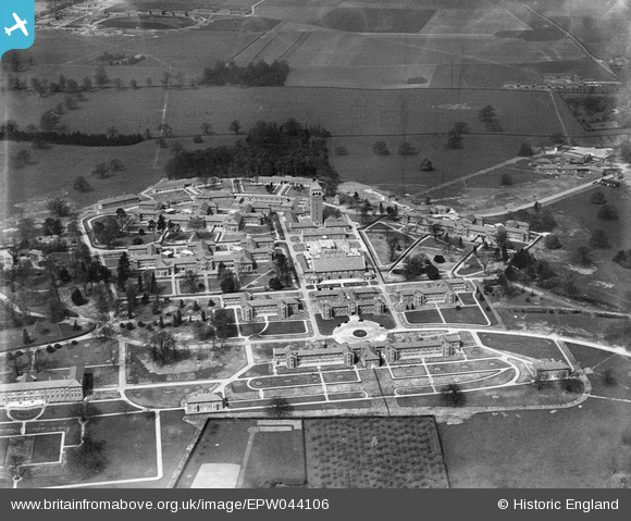
EPW044106 ENGLAND (1934). The Shenley Psychiatric Hospital, Shenley, 1934
© Copyright OpenStreetMap contributors and licensed by the OpenStreetMap Foundation. 2026. Cartography is licensed as CC BY-SA.
Nearby Images (29)
EPW044106

EPW043675

EPW043671

EAW018905

EAW018907

EPW044112

EPW044108

EAW019115

EPW043667

EAW018908
, Shenley, from the south-east, 1948. This image has been produced from a damaged negative.")
EAW018904

EPW044113

EPW044105

EPW043679

EPW049672

EAW019112

EPW044110

EPW043664

EPW044103

EPW044107

EAW019110

EPW044109

EPW044111

EPW043670

EAW018900

EAW018910

EPW015745

EAW018902

EAW018901

Details
| Title | [EPW044106] The Shenley Psychiatric Hospital, Shenley, 1934 |
| Reference | EPW044106 |
| Date | April-1934 |
| Link | |
| Place name | SHENLEY |
| Parish | SHENLEY |
| District | |
| Country | ENGLAND |
| Easting / Northing | 518213, 200950 |
| Longitude / Latitude | -0.28944703750986, 51.69437508876 |
| National Grid Reference | TL182010 |
Pins
Be the first to add a comment to this image!