
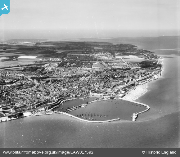
EAW017592 ENGLAND (1948). The Royal Harbour and town, Ramsgate, from the south, 1948. This image has been produced from a print.
© Copyright OpenStreetMap contributors and licensed by the OpenStreetMap Foundation. 2026. Cartography is licensed as CC BY-SA.
Nearby Images (27)
EAW017592

EPW018653

EPW018650

EAW009006

EPW000091

EAW015835

EAW009007

EPW000598

EAW009009

EAW009008

EAW015836

EPW039354

EPW035449

EAW009010

EAW006165

EAW006164

EPW000092

EPW000604

EAW020487

EPW000096

EPW042864

EAW017589

EAW008999

EAW020488

EPW039324

EAW696658

EPW048783

Details
| Title | [EAW017592] The Royal Harbour and town, Ramsgate, from the south, 1948. This image has been produced from a print. |
| Reference | EAW017592 |
| Date | 22-July-1948 |
| Link | |
| Place name | RAMSGATE |
| Parish | RAMSGATE |
| District | |
| Country | ENGLAND |
| Easting / Northing | 638354, 164612 |
| Longitude / Latitude | 1.4219301917031, 51.330059941718 |
| National Grid Reference | TR384646 |
Pins
 |

John W |
Friday 7th of October 2016 09:00:38 PM |

Alan McFaden |
Thursday 28th of August 2014 03:26:38 PM | |
|
Alan McFaden |
Thursday 28th of August 2014 03:25:53 PM | |
|
Alan McFaden |
Thursday 28th of August 2014 03:25:14 PM | |
|
Alan McFaden |
Thursday 28th of August 2014 03:24:40 PM | |
|
Alan McFaden |
Thursday 28th of August 2014 03:23:50 PM | |
|
Alan McFaden |
Thursday 28th of August 2014 03:23:17 PM |


