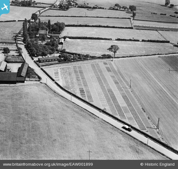
EAW001899 ENGLAND (1946). The Gartons Ltd Plant Breeding Grounds, Little Leigh, 1946
© Copyright OpenStreetMap contributors and licensed by the OpenStreetMap Foundation. 2026. Cartography is licensed as CC BY-SA.
Nearby Images (39)
Details
| Title | [EAW001899] The Gartons Ltd Plant Breeding Grounds, Little Leigh, 1946 |
| Reference | EAW001899 |
| Date | 12-July-1946 |
| Link | |
| Place name | LITTLE LEIGH |
| Parish | LITTLE LEIGH |
| District | |
| Country | ENGLAND |
| Easting / Northing | 361504, 377282 |
| Longitude / Latitude | -2.577568752136, 53.290827389849 |
| National Grid Reference | SJ615773 |
Pins
Be the first to add a comment to this image!


![[EAW001899] The Gartons Ltd Plant Breeding Grounds, Little Leigh, 1946](http://britainfromabove.org.uk/sites/all/libraries/aerofilms-images/public/100x100/EAW/001/EAW001899.jpg)
![[EAW001901] The Gartons Ltd Plant Breeding Grounds, Little Leigh, 1946](http://britainfromabove.org.uk/sites/all/libraries/aerofilms-images/public/100x100/EAW/001/EAW001901.jpg)
![[EAW001903] The Gartons Ltd Plant Breeding Grounds, Little Leigh, 1946](http://britainfromabove.org.uk/sites/all/libraries/aerofilms-images/public/100x100/EAW/001/EAW001903.jpg)
![[EAW001902] The Gartons Ltd Plant Breeding Grounds, Little Leigh, 1946](http://britainfromabove.org.uk/sites/all/libraries/aerofilms-images/public/100x100/EAW/001/EAW001902.jpg)
![[EPW032591] Trial plots and cultivated fields around Ash House Lane, Little Leigh, 1930. This image has been produced from a damaged negative.](http://britainfromabove.org.uk/sites/all/libraries/aerofilms-images/public/100x100/EPW/032/EPW032591.jpg)
![[EAW030041] The Gartons Ltd Plant Breeding Grounds on Ash House Lane, Little Leigh, 1950](http://britainfromabove.org.uk/sites/all/libraries/aerofilms-images/public/100x100/EAW/030/EAW030041.jpg)
![[EAW001900] The Gartons Ltd Plant Breeding Grounds, Little Leigh, 1946](http://britainfromabove.org.uk/sites/all/libraries/aerofilms-images/public/100x100/EAW/001/EAW001900.jpg)
![[EAW001904] Ash House and the Gartons Ltd Plant Breeding Grounds, Little Leigh, 1946](http://britainfromabove.org.uk/sites/all/libraries/aerofilms-images/public/100x100/EAW/001/EAW001904.jpg)
![[EAW030018] Ash Tree Farm and Ash House Lane, Little Leigh, from the north, 1950. This image was marked by Aerofilms Ltd for photo editing.](http://britainfromabove.org.uk/sites/all/libraries/aerofilms-images/public/100x100/EAW/030/EAW030018.jpg)
![[EAW030043] The Gartons Ltd Plant Breeding Grounds on Ash House Lane, Little Leigh, 1950](http://britainfromabove.org.uk/sites/all/libraries/aerofilms-images/public/100x100/EAW/030/EAW030043.jpg)
![[EPW057552] The Gartons Ltd Plant Breeding Grounds, Little Leigh, 1938](http://britainfromabove.org.uk/sites/all/libraries/aerofilms-images/public/100x100/EPW/057/EPW057552.jpg)
![[EAW016760] The Gartons Ltd Plant Breeding Station, Little Leigh, 1948. This image was marked by Aerofilms Ltd for photo editing.](http://britainfromabove.org.uk/sites/all/libraries/aerofilms-images/public/100x100/EAW/016/EAW016760.jpg)
![[EAW030038] Ash Tree Farm, Little Leigh, 1950. This image was marked by Aerofilms Ltd for photo editing.](http://britainfromabove.org.uk/sites/all/libraries/aerofilms-images/public/100x100/EAW/030/EAW030038.jpg)
![[EAW030017] Ash Tree Farm, Little Leigh, 1950](http://britainfromabove.org.uk/sites/all/libraries/aerofilms-images/public/100x100/EAW/030/EAW030017.jpg)
![[EAW030039] Ash Tree Farm, Little Leigh, 1950. This image was marked by Aerofilms Ltd for photo editing.](http://britainfromabove.org.uk/sites/all/libraries/aerofilms-images/public/100x100/EAW/030/EAW030039.jpg)
![[EAW030023] The Gartons Ltd Plant Breeding Grounds on Ash House Lane, Little Leigh, 1950. This image was marked by Aerofilms Ltd for photo editing.](http://britainfromabove.org.uk/sites/all/libraries/aerofilms-images/public/100x100/EAW/030/EAW030023.jpg)
![[EAW017281] Gartons Ltd Plant Breeding Station by The Homestead, Little Leigh, 1948. This image has been produced from a print marked by Aerofilms Ltd for photo editing.](http://britainfromabove.org.uk/sites/all/libraries/aerofilms-images/public/100x100/EAW/017/EAW017281.jpg)
![[EAW030036] Ash Tree Farm, Little Leigh, 1950](http://britainfromabove.org.uk/sites/all/libraries/aerofilms-images/public/100x100/EAW/030/EAW030036.jpg)
![[EAW030042] The Gartons Ltd Plant Breeding Grounds on Ash House Lane, Little Leigh, from the north-west, 1950](http://britainfromabove.org.uk/sites/all/libraries/aerofilms-images/public/100x100/EAW/030/EAW030042.jpg)
![[EPW032584] Trial plots and cultivated fields around Ash House Lane, Little Leigh, from the south-west, 1930. This image has been produced from a damaged negative.](http://britainfromabove.org.uk/sites/all/libraries/aerofilms-images/public/100x100/EPW/032/EPW032584.jpg)
![[EAW017280] Gartons Ltd Plant Breeding Station by The Homestead, Little Leigh, 1948. This image has been produced from a print marked by Aerofilms Ltd for photo editing.](http://britainfromabove.org.uk/sites/all/libraries/aerofilms-images/public/100x100/EAW/017/EAW017280.jpg)
![[EAW030037] Ash House and Ash Tree Cottages, Little Leigh, 1950. This image was marked by Aerofilms Ltd for photo editing.](http://britainfromabove.org.uk/sites/all/libraries/aerofilms-images/public/100x100/EAW/030/EAW030037.jpg)
![[EPW057560] The Gartons Ltd Plant Breeding Grounds, Little Leigh, 1938](http://britainfromabove.org.uk/sites/all/libraries/aerofilms-images/public/100x100/EPW/057/EPW057560.jpg)
![[EPW057555] The Gartons Ltd Plant Breeding Grounds, Little Leigh, 1938](http://britainfromabove.org.uk/sites/all/libraries/aerofilms-images/public/100x100/EPW/057/EPW057555.jpg)
![[EAW016765] The Gartons Ltd Plant Breeding Station, Little Leigh, 1948. This image was marked by Aerofilms Ltd for photo editing.](http://britainfromabove.org.uk/sites/all/libraries/aerofilms-images/public/100x100/EAW/016/EAW016765.jpg)
![[EAW016762] The Gartons Ltd Plant Breeding Station, Little Leigh, 1948. This image was marked by Aerofilms Ltd for photo editing.](http://britainfromabove.org.uk/sites/all/libraries/aerofilms-images/public/100x100/EAW/016/EAW016762.jpg)
![[EPW057551] The Gartons Ltd Plant Breeding Grounds, Little Leigh, 1938](http://britainfromabove.org.uk/sites/all/libraries/aerofilms-images/public/100x100/EPW/057/EPW057551.jpg)
![[EPW032587] Trial plots and cultivated fields around Ash House Lane, Little Leigh, from the south-east, 1930](http://britainfromabove.org.uk/sites/all/libraries/aerofilms-images/public/100x100/EPW/032/EPW032587.jpg)
![[EAW016763] The Gartons Ltd Plant Breeding Station, Little Leigh, 1948. This image was marked by Aerofilms Ltd for photo editing.](http://britainfromabove.org.uk/sites/all/libraries/aerofilms-images/public/100x100/EAW/016/EAW016763.jpg)
![[EAW017278] Gartons Ltd Plant Breeding Station by The Homestead, Little Leigh, 1948. This image has been produced from a print marked by Aerofilms Ltd for photo editing.](http://britainfromabove.org.uk/sites/all/libraries/aerofilms-images/public/100x100/EAW/017/EAW017278.jpg)
![[EPW057553] The Gartons Ltd Plant Breeding Grounds, Little Leigh, 1938](http://britainfromabove.org.uk/sites/all/libraries/aerofilms-images/public/100x100/EPW/057/EPW057553.jpg)
![[EPW032586] Trial plots and cultivated fields around Ash House Lane, Little Leigh, from the north-east, 1930](http://britainfromabove.org.uk/sites/all/libraries/aerofilms-images/public/100x100/EPW/032/EPW032586.jpg)
![[EAW030021] The Gartons Ltd Plant Breeding Grounds on Ash House Lane, Little Leigh, 1950](http://britainfromabove.org.uk/sites/all/libraries/aerofilms-images/public/100x100/EAW/030/EAW030021.jpg)
![[EAW016764] The Gartons Ltd Plant Breeding Station, Little Leigh, 1948. This image was marked by Aerofilms Ltd for photo editing.](http://britainfromabove.org.uk/sites/all/libraries/aerofilms-images/public/100x100/EAW/016/EAW016764.jpg)
![[EAW030022] The Gartons Ltd Plant Breeding Grounds on Ash House Lane, Little Leigh, 1950. This image was marked by Aerofilms Ltd for photo editing.](http://britainfromabove.org.uk/sites/all/libraries/aerofilms-images/public/100x100/EAW/030/EAW030022.jpg)
![[EPW057549] The Gartons Ltd Plant Breeding Grounds, Little Leigh, 1938](http://britainfromabove.org.uk/sites/all/libraries/aerofilms-images/public/100x100/EPW/057/EPW057549.jpg)
![[EAW016761] The Gartons Ltd Plant Breeding Station, Little Leigh, 1948. This image was marked by Aerofilms Ltd for photo editing.](http://britainfromabove.org.uk/sites/all/libraries/aerofilms-images/public/100x100/EAW/016/EAW016761.jpg)
![[EPW032590] Trial plots and cultivated fields around Ash House Lane, Little Leigh, from the south-east, 1930. This image has been affected by flare.](http://britainfromabove.org.uk/sites/all/libraries/aerofilms-images/public/100x100/EPW/032/EPW032590.jpg)
![[EPW032580] Trial plots and cultivated fields around Ash House Lane, Little Leigh, from the south-east, 1930](http://britainfromabove.org.uk/sites/all/libraries/aerofilms-images/public/100x100/EPW/032/EPW032580.jpg)