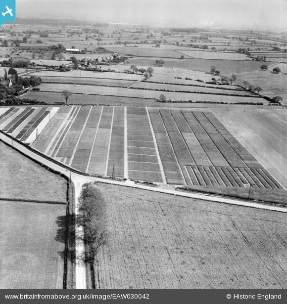
EAW030042 ENGLAND (1950). The Gartons Ltd Plant Breeding Grounds on Ash House Lane, Little Leigh, from the north-west, 1950
© Copyright OpenStreetMap contributors and licensed by the OpenStreetMap Foundation. 2026. Cartography is licensed as CC BY-SA.
Nearby Images (35)
Details
| Title | [EAW030042] The Gartons Ltd Plant Breeding Grounds on Ash House Lane, Little Leigh, from the north-west, 1950 |
| Reference | EAW030042 |
| Date | 1-June-1950 |
| Link | |
| Place name | LITTLE LEIGH |
| Parish | LITTLE LEIGH |
| District | |
| Country | ENGLAND |
| Easting / Northing | 361349, 377265 |
| Longitude / Latitude | -2.5798920708602, 53.290663288359 |
| National Grid Reference | SJ613773 |
Pins
Be the first to add a comment to this image!


![[EAW030042] The Gartons Ltd Plant Breeding Grounds on Ash House Lane, Little Leigh, from the north-west, 1950](http://britainfromabove.org.uk/sites/all/libraries/aerofilms-images/public/100x100/EAW/030/EAW030042.jpg)
![[EAW017281] Gartons Ltd Plant Breeding Station by The Homestead, Little Leigh, 1948. This image has been produced from a print marked by Aerofilms Ltd for photo editing.](http://britainfromabove.org.uk/sites/all/libraries/aerofilms-images/public/100x100/EAW/017/EAW017281.jpg)
![[EAW017280] Gartons Ltd Plant Breeding Station by The Homestead, Little Leigh, 1948. This image has been produced from a print marked by Aerofilms Ltd for photo editing.](http://britainfromabove.org.uk/sites/all/libraries/aerofilms-images/public/100x100/EAW/017/EAW017280.jpg)
![[EAW016760] The Gartons Ltd Plant Breeding Station, Little Leigh, 1948. This image was marked by Aerofilms Ltd for photo editing.](http://britainfromabove.org.uk/sites/all/libraries/aerofilms-images/public/100x100/EAW/016/EAW016760.jpg)
![[EAW017278] Gartons Ltd Plant Breeding Station by The Homestead, Little Leigh, 1948. This image has been produced from a print marked by Aerofilms Ltd for photo editing.](http://britainfromabove.org.uk/sites/all/libraries/aerofilms-images/public/100x100/EAW/017/EAW017278.jpg)
![[EAW016764] The Gartons Ltd Plant Breeding Station, Little Leigh, 1948. This image was marked by Aerofilms Ltd for photo editing.](http://britainfromabove.org.uk/sites/all/libraries/aerofilms-images/public/100x100/EAW/016/EAW016764.jpg)
![[EAW016765] The Gartons Ltd Plant Breeding Station, Little Leigh, 1948. This image was marked by Aerofilms Ltd for photo editing.](http://britainfromabove.org.uk/sites/all/libraries/aerofilms-images/public/100x100/EAW/016/EAW016765.jpg)
![[EAW016763] The Gartons Ltd Plant Breeding Station, Little Leigh, 1948. This image was marked by Aerofilms Ltd for photo editing.](http://britainfromabove.org.uk/sites/all/libraries/aerofilms-images/public/100x100/EAW/016/EAW016763.jpg)
![[EAW001900] The Gartons Ltd Plant Breeding Grounds, Little Leigh, 1946](http://britainfromabove.org.uk/sites/all/libraries/aerofilms-images/public/100x100/EAW/001/EAW001900.jpg)
![[EAW016762] The Gartons Ltd Plant Breeding Station, Little Leigh, 1948. This image was marked by Aerofilms Ltd for photo editing.](http://britainfromabove.org.uk/sites/all/libraries/aerofilms-images/public/100x100/EAW/016/EAW016762.jpg)
![[EAW030041] The Gartons Ltd Plant Breeding Grounds on Ash House Lane, Little Leigh, 1950](http://britainfromabove.org.uk/sites/all/libraries/aerofilms-images/public/100x100/EAW/030/EAW030041.jpg)
![[EAW030043] The Gartons Ltd Plant Breeding Grounds on Ash House Lane, Little Leigh, 1950](http://britainfromabove.org.uk/sites/all/libraries/aerofilms-images/public/100x100/EAW/030/EAW030043.jpg)
![[EPW057552] The Gartons Ltd Plant Breeding Grounds, Little Leigh, 1938](http://britainfromabove.org.uk/sites/all/libraries/aerofilms-images/public/100x100/EPW/057/EPW057552.jpg)
![[EPW057555] The Gartons Ltd Plant Breeding Grounds, Little Leigh, 1938](http://britainfromabove.org.uk/sites/all/libraries/aerofilms-images/public/100x100/EPW/057/EPW057555.jpg)
![[EPW057560] The Gartons Ltd Plant Breeding Grounds, Little Leigh, 1938](http://britainfromabove.org.uk/sites/all/libraries/aerofilms-images/public/100x100/EPW/057/EPW057560.jpg)
![[EAW001903] The Gartons Ltd Plant Breeding Grounds, Little Leigh, 1946](http://britainfromabove.org.uk/sites/all/libraries/aerofilms-images/public/100x100/EAW/001/EAW001903.jpg)
![[EAW030023] The Gartons Ltd Plant Breeding Grounds on Ash House Lane, Little Leigh, 1950. This image was marked by Aerofilms Ltd for photo editing.](http://britainfromabove.org.uk/sites/all/libraries/aerofilms-images/public/100x100/EAW/030/EAW030023.jpg)
![[EAW001899] The Gartons Ltd Plant Breeding Grounds, Little Leigh, 1946](http://britainfromabove.org.uk/sites/all/libraries/aerofilms-images/public/100x100/EAW/001/EAW001899.jpg)
![[EAW001901] The Gartons Ltd Plant Breeding Grounds, Little Leigh, 1946](http://britainfromabove.org.uk/sites/all/libraries/aerofilms-images/public/100x100/EAW/001/EAW001901.jpg)
![[EPW057553] The Gartons Ltd Plant Breeding Grounds, Little Leigh, 1938](http://britainfromabove.org.uk/sites/all/libraries/aerofilms-images/public/100x100/EPW/057/EPW057553.jpg)
![[EPW057551] The Gartons Ltd Plant Breeding Grounds, Little Leigh, 1938](http://britainfromabove.org.uk/sites/all/libraries/aerofilms-images/public/100x100/EPW/057/EPW057551.jpg)
![[EAW030018] Ash Tree Farm and Ash House Lane, Little Leigh, from the north, 1950. This image was marked by Aerofilms Ltd for photo editing.](http://britainfromabove.org.uk/sites/all/libraries/aerofilms-images/public/100x100/EAW/030/EAW030018.jpg)
![[EAW001904] Ash House and the Gartons Ltd Plant Breeding Grounds, Little Leigh, 1946](http://britainfromabove.org.uk/sites/all/libraries/aerofilms-images/public/100x100/EAW/001/EAW001904.jpg)
![[EAW030021] The Gartons Ltd Plant Breeding Grounds on Ash House Lane, Little Leigh, 1950](http://britainfromabove.org.uk/sites/all/libraries/aerofilms-images/public/100x100/EAW/030/EAW030021.jpg)
![[EAW001902] The Gartons Ltd Plant Breeding Grounds, Little Leigh, 1946](http://britainfromabove.org.uk/sites/all/libraries/aerofilms-images/public/100x100/EAW/001/EAW001902.jpg)
![[EPW032591] Trial plots and cultivated fields around Ash House Lane, Little Leigh, 1930. This image has been produced from a damaged negative.](http://britainfromabove.org.uk/sites/all/libraries/aerofilms-images/public/100x100/EPW/032/EPW032591.jpg)
![[EPW057549] The Gartons Ltd Plant Breeding Grounds, Little Leigh, 1938](http://britainfromabove.org.uk/sites/all/libraries/aerofilms-images/public/100x100/EPW/057/EPW057549.jpg)
![[EAW030022] The Gartons Ltd Plant Breeding Grounds on Ash House Lane, Little Leigh, 1950. This image was marked by Aerofilms Ltd for photo editing.](http://britainfromabove.org.uk/sites/all/libraries/aerofilms-images/public/100x100/EAW/030/EAW030022.jpg)
![[EAW016759] The Gartons Ltd Plant Breeding Station, Little Leigh, 1948. This image was marked by Aerofilms Ltd for photo editing.](http://britainfromabove.org.uk/sites/all/libraries/aerofilms-images/public/100x100/EAW/016/EAW016759.jpg)
![[EAW017277] Gartons Ltd Plant Breeding Station off Ash House Lane and environs, Little Leigh, 1948. This image has been produced from a print marked by Aerofilms Ltd for photo editing.](http://britainfromabove.org.uk/sites/all/libraries/aerofilms-images/public/100x100/EAW/017/EAW017277.jpg)
![[EPW032584] Trial plots and cultivated fields around Ash House Lane, Little Leigh, from the south-west, 1930. This image has been produced from a damaged negative.](http://britainfromabove.org.uk/sites/all/libraries/aerofilms-images/public/100x100/EPW/032/EPW032584.jpg)
![[EAW017276] Gartons Ltd Plant Breeding Station off Ash House Lane, Little Leigh, 1948. This image has been produced from a print marked by Aerofilms Ltd for photo editing.](http://britainfromabove.org.uk/sites/all/libraries/aerofilms-images/public/100x100/EAW/017/EAW017276.jpg)
![[EAW016761] The Gartons Ltd Plant Breeding Station, Little Leigh, 1948. This image was marked by Aerofilms Ltd for photo editing.](http://britainfromabove.org.uk/sites/all/libraries/aerofilms-images/public/100x100/EAW/016/EAW016761.jpg)
![[EPW032588] Trial plots and cultivated fields around Ash House Lane, Little Leigh, from the north-west, 1930. This image has been produced from a damaged negative.](http://britainfromabove.org.uk/sites/all/libraries/aerofilms-images/public/100x100/EPW/032/EPW032588.jpg)
![[EAW017279] Gartons Ltd Plant Breeding Station off Ash House Lane and environs, Little Leigh, 1948. This image has been produced from a print.](http://britainfromabove.org.uk/sites/all/libraries/aerofilms-images/public/100x100/EAW/017/EAW017279.jpg)