
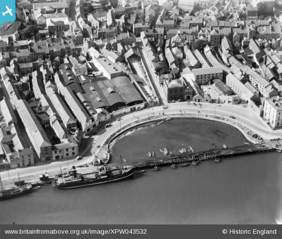
XPW043532 IRELAND (1933). General View, Wexford, Wexford, Ireland, 1933. Oblique aerial photograph taken facing West.
© Hawlfraint cyfranwyr OpenStreetMap a thrwyddedwyd gan yr OpenStreetMap Foundation. 2026. Trwyddedir y gartograffeg fel CC BY-SA.
Delweddau cyfagos (3)
XPW043532

XPW043531

XPW043535

Manylion
| Pennawd | [XPW043532] General View, Wexford, Wexford, Ireland, 1933. Oblique aerial photograph taken facing West. |
| Cyfeirnod | XPW043532 |
| Dyddiad | 1933 |
| Dolen | |
| Enw lle | WEXFORD |
| Plwyf | IRELAND |
| Ardal | |
| Gwlad | IRELAND |
| Dwyreiniad / Gogleddiad | 96259, 280384 |
| Hydred / Lledred | -6.46045, 52.337208 |
| Cyfeirnod Grid Cenedlaethol |
Pinnau

John Swain |
Wednesday 8th of October 2014 02:07:06 PM | |
|
John Swain |
Wednesday 8th of October 2014 01:59:49 PM | |
|
John Swain |
Wednesday 8th of October 2014 01:59:01 PM | |
|
John Swain |
Wednesday 8th of October 2014 01:58:21 PM | |
|
John Swain |
Wednesday 8th of October 2014 01:57:52 PM | |
|
John Swain |
Wednesday 8th of October 2014 01:56:53 PM | |
|
John Swain |
Wednesday 8th of October 2014 01:56:07 PM |
Cyfraniadau Grŵp
The Crescent Quay represents the deep pool around which the original Viking town was founded. After the building of the quays on reclaimed land in the early 19th century, the flow of water was changed and the Crescent silted up. The quayside railway bridge was added in the 1880s and a marina has since been established as part of a waterfront development. |
John Swain |
Wednesday 8th of October 2014 02:05:40 PM |