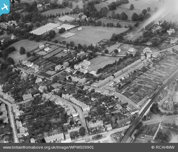
WPW029901 WALES (1929). General view of Abergavenny, oblique aerial view. 5"x4" black and white glass plate negative.
© Hawlfraint cyfranwyr OpenStreetMap a thrwyddedwyd gan yr OpenStreetMap Foundation. 2026. Trwyddedir y gartograffeg fel CC BY-SA.
Delweddau cyfagos (30)
Manylion
| Pennawd | [WPW029901] General view of Abergavenny, oblique aerial view. 5"x4" black and white glass plate negative. |
| Cyfeirnod | WPW029901 |
| Dyddiad | 1929 |
| Dolen | Coflein Archive Item 6370701 |
| Enw lle | |
| Plwyf | |
| Ardal | |
| Gwlad | WALES |
| Dwyreiniad / Gogleddiad | 329833, 214333 |
| Hydred / Lledred | -3.0181841706239, 51.822762430277 |
| Cyfeirnod Grid Cenedlaethol | SO298143 |
Pinnau

Beccy |
Friday 23rd of September 2016 04:24:23 PM | |

Beccy |
Wednesday 21st of September 2016 02:23:52 PM | |

Western Road |
Friday 16th of November 2012 11:04:12 PM | |

Stewart Lawrie |
Monday 24th of September 2012 02:19:52 PM | |

Stewart Lawrie |
Monday 24th of September 2012 02:18:51 PM | |

Stewart Lawrie |
Monday 24th of September 2012 02:17:17 PM | |
I seem to remember that the original station buildings were used as a Social Club associated with an adjacent hospital at about 1970. I remember dropping the jackpot on a fruit machine here! |

Class31 |
Monday 6th of April 2015 08:13:07 AM |


![[WAW000674] View of landscape south of Abergavenny showing the railway and river Usk](http://britainfromabove.org.uk/sites/all/libraries/aerofilms-images/public/100x100/WAW/000/WAW000674.jpg)
![[WAW000675] View of landscape south of Abergavenny showing the railway and river Usk](http://britainfromabove.org.uk/sites/all/libraries/aerofilms-images/public/100x100/WAW/000/WAW000675.jpg)
![[WAW000676] View of landscape south of Abergavenny showing the railway and river Usk](http://britainfromabove.org.uk/sites/all/libraries/aerofilms-images/public/100x100/WAW/000/WAW000676.jpg)
![[WAW000677] View of landscape south of Abergavenny showing the railway and river Usk](http://britainfromabove.org.uk/sites/all/libraries/aerofilms-images/public/100x100/WAW/000/WAW000677.jpg)
![[WAW000678] View of landscape south of Abergavenny showing the railway and river Usk](http://britainfromabove.org.uk/sites/all/libraries/aerofilms-images/public/100x100/WAW/000/WAW000678.jpg)
![[WAW000679] View of landscape south of Abergavenny showing the railway and river Usk](http://britainfromabove.org.uk/sites/all/libraries/aerofilms-images/public/100x100/WAW/000/WAW000679.jpg)
![[WAW000680] View of landscape south of Abergavenny showing the railway and river Usk](http://britainfromabove.org.uk/sites/all/libraries/aerofilms-images/public/100x100/WAW/000/WAW000680.jpg)
![[WAW000681] View of landscape south of Abergavenny showing the railway and river Usk](http://britainfromabove.org.uk/sites/all/libraries/aerofilms-images/public/100x100/WAW/000/WAW000681.jpg)
![[WAW026200] View possibly of the Sugarloaf, Abergavenny](http://britainfromabove.org.uk/sites/all/libraries/aerofilms-images/public/100x100/WAW/026/WAW026200.jpg)
![[WAW026201] View possibly of the Sugarloaf, Abergavenny](http://britainfromabove.org.uk/sites/all/libraries/aerofilms-images/public/100x100/WAW/026/WAW026201.jpg)
![[WAW026202] View of Abergavenny showing cattle market](http://britainfromabove.org.uk/sites/all/libraries/aerofilms-images/public/100x100/WAW/026/WAW026202.jpg)
![[WAW026203] View of Abergavenny showing castle](http://britainfromabove.org.uk/sites/all/libraries/aerofilms-images/public/100x100/WAW/026/WAW026203.jpg)
![[WAW026204] View of Abergavenny showing castle](http://britainfromabove.org.uk/sites/all/libraries/aerofilms-images/public/100x100/WAW/026/WAW026204.jpg)
![[WAW026205] Landscape view near Abergavenny](http://britainfromabove.org.uk/sites/all/libraries/aerofilms-images/public/100x100/WAW/026/WAW026205.jpg)
![[WPW029891] General view of Abergavenny, oblique aerial view. 5"x4" black and white glass plate negative.](http://britainfromabove.org.uk/sites/all/libraries/aerofilms-images/public/100x100/WPW/029/WPW029891.jpg)
![[WPW029892] General view of Abergavenny, oblique aerial view. 5"x4" black and white glass plate negative.](http://britainfromabove.org.uk/sites/all/libraries/aerofilms-images/public/100x100/WPW/029/WPW029892.jpg)
![[WPW029893] General view of Abergavenny, oblique aerial view. 5"x4" black and white glass plate negative.](http://britainfromabove.org.uk/sites/all/libraries/aerofilms-images/public/100x100/WPW/029/WPW029893.jpg)
![[WPW029897] General view of Abergavenny, oblique aerial view. 5"x4" black and white glass plate negative.](http://britainfromabove.org.uk/sites/all/libraries/aerofilms-images/public/100x100/WPW/029/WPW029897.jpg)
![[WPW029898] General view of Abergavenny, oblique aerial view. 5"x4" black and white glass plate negative.](http://britainfromabove.org.uk/sites/all/libraries/aerofilms-images/public/100x100/WPW/029/WPW029898.jpg)
![[WPW029899] View of Abergavenny showing cattle market and Bailey Park, oblique aerial view. 5"x4" black and white glass plate negative.](http://britainfromabove.org.uk/sites/all/libraries/aerofilms-images/public/100x100/WPW/029/WPW029899.jpg)
![[WPW029900] General view of Abergavenny, oblique aerial view. 5"x4" black and white glass plate negative.](http://britainfromabove.org.uk/sites/all/libraries/aerofilms-images/public/100x100/WPW/029/WPW029900.jpg)
![[WPW029901] General view of Abergavenny, oblique aerial view. 5"x4" black and white glass plate negative.](http://britainfromabove.org.uk/sites/all/libraries/aerofilms-images/public/100x100/WPW/029/WPW029901.jpg)
![[WPW029909] General view of Abergavenny, oblique aerial view. 5"x4" black and white glass plate negative.](http://britainfromabove.org.uk/sites/all/libraries/aerofilms-images/public/100x100/WPW/029/WPW029909.jpg)
![[WPW029950] General view of Abergavenny showing the Merthyr, Tredegar & Abergavenny railway line. Oblique aerial photograph, 5"x4" BW glass plate.](http://britainfromabove.org.uk/sites/all/libraries/aerofilms-images/public/100x100/WPW/029/WPW029950.jpg)
![[WPW029976] General view of Abergavenny showing the Angel Hotel and St Mary's Priory and church. Oblique aerial photograph.](http://britainfromabove.org.uk/sites/all/libraries/aerofilms-images/public/100x100/WPW/029/WPW029976.jpg)
![[WPW039965] General view of Abergavenny, oblique aerial view. 5"x4" black and white glass plate negative.](http://britainfromabove.org.uk/sites/all/libraries/aerofilms-images/public/100x100/WPW/039/WPW039965.jpg)
![[WPW039966] General view of Abergavenny, oblique aerial view. 5"x4" black and white glass plate negative.](http://britainfromabove.org.uk/sites/all/libraries/aerofilms-images/public/100x100/WPW/039/WPW039966.jpg)
![[WPW039967] General view of Abergavenny, oblique aerial view. 5"x4" black and white glass plate negative.](http://britainfromabove.org.uk/sites/all/libraries/aerofilms-images/public/100x100/WPW/039/WPW039967.jpg)
![[WPW039968] General view of Abergavenny, oblique aerial view. 5"x4" black and white glass plate negative.](http://britainfromabove.org.uk/sites/all/libraries/aerofilms-images/public/100x100/WPW/039/WPW039968.jpg)
![[WPW039969] General view of Abergavenny, oblique aerial view. 5"x4" black and white glass plate negative.](http://britainfromabove.org.uk/sites/all/libraries/aerofilms-images/public/100x100/WPW/039/WPW039969.jpg)