
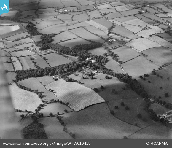
WPW019415 WALES (1927). View of Bronwylfa Hall, oblique aerial view. 5"x4" black and white glass plate negative.
© Hawlfraint cyfranwyr OpenStreetMap a thrwyddedwyd gan yr OpenStreetMap Foundation. 2026. Trwyddedir y gartograffeg fel CC BY-SA.
Delweddau cyfagos (10)
WPW019410

WPW019411

WPW019412

WPW019413

WPW019414

WPW019415

WPW019416

WPW019418

WPW019420

WPW019421

Manylion
| Pennawd | [WPW019415] View of Bronwylfa Hall, oblique aerial view. 5"x4" black and white glass plate negative. |
| Cyfeirnod | WPW019415 |
| Dyddiad | 1927 |
| Dolen | Coflein Archive Item 6378315 |
| Enw lle | |
| Plwyf | |
| Ardal | |
| Gwlad | WALES |
| Dwyreiniad / Gogleddiad | 328290, 348280 |
| Hydred / Lledred | -3.06931786492, 53.02669212835 |
| Cyfeirnod Grid Cenedlaethol | SJ283483 |
Pinnau

Class31 |
Tuesday 17th of July 2012 10:19:34 AM | |
|
Class31 |
Tuesday 17th of July 2012 10:19:08 AM | |
|
Class31 |
Tuesday 17th of July 2012 10:18:45 AM | |
|
Class31 |
Tuesday 17th of July 2012 10:17:29 AM | |
|
Class31 |
Tuesday 17th of July 2012 10:16:52 AM | |
|
Class31 |
Tuesday 17th of July 2012 10:11:00 AM | |
|
Class31 |
Tuesday 17th of July 2012 10:10:42 AM |
Cyfraniadau Grŵp
This is a positive identication of bronwylfa Hall, two miles west of Rhostyllen, Wrexham. Ty Mawr Reservoir and Gronwen filters are to the top left of shot. To the top righr are Tyddyn Dedwydd and Tan-y-rhiw. To the bottom right is Home Farm. Map Reference is SJ 28330 48255 |
Class31 |
Tuesday 17th of July 2012 10:23:19 AM |