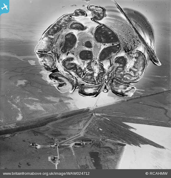
WAW024712 WALES (1949). View of the dredging of the Shotton steelworks site (commissioned by Westminster Dredging Co.)
© Hawlfraint cyfranwyr OpenStreetMap a thrwyddedwyd gan yr OpenStreetMap Foundation. 2026. Trwyddedir y gartograffeg fel CC BY-SA.
Delweddau cyfagos (48)
Manylion
| Pennawd | [WAW024712] View of the dredging of the Shotton steelworks site (commissioned by Westminster Dredging Co.) |
| Cyfeirnod | WAW024712 |
| Dyddiad | 12-July-1949 |
| Dolen | Coflein Archive Item 6414074 |
| Enw lle | |
| Plwyf | |
| Ardal | |
| Gwlad | WALES |
| Dwyreiniad / Gogleddiad | 330500, 370500 |
| Hydred / Lledred | -3.0411853684416, 53.226709296404 |
| Cyfeirnod Grid Cenedlaethol | SJ305705 |
Pinnau

Matt Aldred edob.mattaldred.com |
Sunday 6th of December 2020 08:03:21 PM |
Cyfraniadau Grŵp
Broken Bank, showing area where sand was dumped to create a raised section near to the current shooting range (see bank also created at right angles to the Broken Bank). Now it is the model aircraft area. The bottom buildings are part of the Sealand shooting ranges that are now covered over. |

e10694 |
Monday 3rd of November 2014 08:31:47 PM |


![[WAW024712] View of the dredging of the Shotton steelworks site (commissioned by Westminster Dredging Co.)](http://britainfromabove.org.uk/sites/all/libraries/aerofilms-images/public/100x100/WAW/024/WAW024712.jpg)
![[WAW024713] View of the dredging of the Shotton steelworks site (commissioned by Westminster Dredging Co.)](http://britainfromabove.org.uk/sites/all/libraries/aerofilms-images/public/100x100/WAW/024/WAW024713.jpg)
![[WAW024714] View of the dredging of the Shotton steelworks site (commissioned by Westminster Dredging Co.)](http://britainfromabove.org.uk/sites/all/libraries/aerofilms-images/public/100x100/WAW/024/WAW024714.jpg)
![[WAW024715] View of the dredging of the Shotton steelworks site (commissioned by Westminster Dredging Co.)](http://britainfromabove.org.uk/sites/all/libraries/aerofilms-images/public/100x100/WAW/024/WAW024715.jpg)
![[WAW024716] View of the dredging of the Shotton steelworks site (commissioned by Westminster Dredging Co.)](http://britainfromabove.org.uk/sites/all/libraries/aerofilms-images/public/100x100/WAW/024/WAW024716.jpg)
![[WAW024717] View of the dredging of the Shotton steelworks site (commissioned by Westminster Dredging Co.)](http://britainfromabove.org.uk/sites/all/libraries/aerofilms-images/public/100x100/WAW/024/WAW024717.jpg)
![[WAW024718] View of the dredging of the Shotton steelworks site (commissioned by Westminster Dredging Co.)](http://britainfromabove.org.uk/sites/all/libraries/aerofilms-images/public/100x100/WAW/024/WAW024718.jpg)
![[WAW024719] View of the dredging of the Shotton steelworks site (commissioned by Westminster Dredging Co.)](http://britainfromabove.org.uk/sites/all/libraries/aerofilms-images/public/100x100/WAW/024/WAW024719.jpg)
![[WAW024720] View of the dredging of the Shotton steelworks site (commissioned by Westminster Dredging Co.)](http://britainfromabove.org.uk/sites/all/libraries/aerofilms-images/public/100x100/WAW/024/WAW024720.jpg)
![[WAW024721] View of the dredging of the Shotton steelworks site (commissioned by Westminster Dredging Co.)](http://britainfromabove.org.uk/sites/all/libraries/aerofilms-images/public/100x100/WAW/024/WAW024721.jpg)
![[WAW024722] View of the dredging of the Shotton steelworks site (commissioned by Westminster Dredging Co.)](http://britainfromabove.org.uk/sites/all/libraries/aerofilms-images/public/100x100/WAW/024/WAW024722.jpg)
![[WAW027362] View of the dredging of the Shotton steelworks site (commissioned by Westminster Dredging Co.). Oblique aerial photograph, 5½" cut roll film.](http://britainfromabove.org.uk/sites/all/libraries/aerofilms-images/public/100x100/WAW/027/WAW027362.jpg)
![[WAW027366] View of of Dee estuary during dreging work for Shotton Steelworks. Commissioned by the Westminster Dredging Co. Ltd.. Oblique aerial photograph, 5½" cut roll film.](http://britainfromabove.org.uk/sites/all/libraries/aerofilms-images/public/100x100/WAW/027/WAW027366.jpg)
![[WAW027367] View of floating pontoon and dreging vessel, during dreging work for Shotton Steelworks. Commissioned by the Westminster Dredging Co. Ltd.. Oblique aerial photograph, 5½" cut roll film.](http://britainfromabove.org.uk/sites/all/libraries/aerofilms-images/public/100x100/WAW/027/WAW027367.jpg)
![[WAW027370] View of of Dee estuary during dreging work for Shotton Steelworks. Commissioned by the Westminster Dredging Co. Ltd.. Oblique aerial photograph, 5½" cut roll film.](http://britainfromabove.org.uk/sites/all/libraries/aerofilms-images/public/100x100/WAW/027/WAW027370.jpg)
![[WAW027382] View of the Shotton steelworks site (commissioned by Westminster Dredging Co.). Oblique aerial photograph, 5½" cut roll film.](http://britainfromabove.org.uk/sites/all/libraries/aerofilms-images/public/100x100/WAW/027/WAW027382.jpg)
![[WAW027383] View of the Shotton steelworks site showing Hawarden Bridge (commissioned by Westminster Dredging Co.). Oblique aerial photograph, 5½" cut roll film.](http://britainfromabove.org.uk/sites/all/libraries/aerofilms-images/public/100x100/WAW/027/WAW027383.jpg)
![[WAW027384] View of the Shotton steelworks site (commissioned by Westminster Dredging Co.). Oblique aerial photograph, 5½" cut roll film.](http://britainfromabove.org.uk/sites/all/libraries/aerofilms-images/public/100x100/WAW/027/WAW027384.jpg)
![[WAW030308] View of dredging work for Shotton Steelworks commissioned by the Westminster Dredging Co. Ltd](http://britainfromabove.org.uk/sites/all/libraries/aerofilms-images/public/100x100/WAW/030/WAW030308.jpg)
![[WAW030309] View of dredging work for Shotton Steelworks commissioned by the Westminster Dredging Co. Ltd](http://britainfromabove.org.uk/sites/all/libraries/aerofilms-images/public/100x100/WAW/030/WAW030309.jpg)
![[WAW030310] View of dredging work for Shotton Steelworks commissioned by the Westminster Dredging Co. Ltd](http://britainfromabove.org.uk/sites/all/libraries/aerofilms-images/public/100x100/WAW/030/WAW030310.jpg)
![[WAW030311] View of dredging work for Shotton Steelworks commissioned by the Westminster Dredging Co. Ltd](http://britainfromabove.org.uk/sites/all/libraries/aerofilms-images/public/100x100/WAW/030/WAW030311.jpg)
![[WAW030312] View of dredging work for Shotton Steelworks commissioned by the Westminster Dredging Co. Ltd](http://britainfromabove.org.uk/sites/all/libraries/aerofilms-images/public/100x100/WAW/030/WAW030312.jpg)
![[WAW030313] View of dredging work for Shotton Steelworks commissioned by the Westminster Dredging Co. Ltd](http://britainfromabove.org.uk/sites/all/libraries/aerofilms-images/public/100x100/WAW/030/WAW030313.jpg)
![[WAW030314] View of dredging work for Shotton Steelworks commissioned by the Westminster Dredging Co. Ltd](http://britainfromabove.org.uk/sites/all/libraries/aerofilms-images/public/100x100/WAW/030/WAW030314.jpg)
![[WAW030315] View of dredging work for Shotton Steelworks commissioned by the Westminster Dredging Co. Ltd](http://britainfromabove.org.uk/sites/all/libraries/aerofilms-images/public/100x100/WAW/030/WAW030315.jpg)
![[WAW030316] View of dredging work (shows men at work), for Shotton Steelworks commissioned by the Westminster Dredging Co. Ltd](http://britainfromabove.org.uk/sites/all/libraries/aerofilms-images/public/100x100/WAW/030/WAW030316.jpg)
![[WAW030317] View of dredging work (shows men at work), for Shotton Steelworks commissioned by the Westminster Dredging Co. Ltd](http://britainfromabove.org.uk/sites/all/libraries/aerofilms-images/public/100x100/WAW/030/WAW030317.jpg)
![[WAW030318] View of dredging work (shows men at work), for Shotton Steelworks commissioned by the Westminster Dredging Co. Ltd](http://britainfromabove.org.uk/sites/all/libraries/aerofilms-images/public/100x100/WAW/030/WAW030318.jpg)
![[WAW030319] View of dredging work for Shotton Steelworks commissioned by the Westminster Dredging Co. Ltd](http://britainfromabove.org.uk/sites/all/libraries/aerofilms-images/public/100x100/WAW/030/WAW030319.jpg)
![[WAW030320] View of dredging work for Shotton Steelworks commissioned by the Westminster Dredging Co. Ltd](http://britainfromabove.org.uk/sites/all/libraries/aerofilms-images/public/100x100/WAW/030/WAW030320.jpg)
![[WAW030321] View of dredging work for Shotton Steelworks commissioned by the Westminster Dredging Co. Ltd](http://britainfromabove.org.uk/sites/all/libraries/aerofilms-images/public/100x100/WAW/030/WAW030321.jpg)
![[WAW030322] View of dredging work for Shotton Steelworks commissioned by the Westminster Dredging Co. Ltd](http://britainfromabove.org.uk/sites/all/libraries/aerofilms-images/public/100x100/WAW/030/WAW030322.jpg)
![[WAW030323] View of dredging work for Shotton Steelworks commissioned by the Westminster Dredging Co. Ltd](http://britainfromabove.org.uk/sites/all/libraries/aerofilms-images/public/100x100/WAW/030/WAW030323.jpg)
![[WAW030324] View of dredging work for Shotton Steelworks commissioned by the Westminster Dredging Co. Ltd](http://britainfromabove.org.uk/sites/all/libraries/aerofilms-images/public/100x100/WAW/030/WAW030324.jpg)
![[WAW030325] View of dredging work for Shotton Steelworks commissioned by the Westminster Dredging Co. Ltd](http://britainfromabove.org.uk/sites/all/libraries/aerofilms-images/public/100x100/WAW/030/WAW030325.jpg)
![[WAW030326] View of dredging work for Shotton Steelworks commissioned by the Westminster Dredging Co. Ltd](http://britainfromabove.org.uk/sites/all/libraries/aerofilms-images/public/100x100/WAW/030/WAW030326.jpg)
![[WAW030327] View of dredging work for Shotton Steelworks commissioned by the Westminster Dredging Co. Ltd](http://britainfromabove.org.uk/sites/all/libraries/aerofilms-images/public/100x100/WAW/030/WAW030327.jpg)
![[WAW030328] View of dredging work for Shotton Steelworks commissioned by the Westminster Dredging Co. Ltd](http://britainfromabove.org.uk/sites/all/libraries/aerofilms-images/public/100x100/WAW/030/WAW030328.jpg)
![[WAW030329] View of dredging work for Shotton Steelworks commissioned by the Westminster Dredging Co. Ltd](http://britainfromabove.org.uk/sites/all/libraries/aerofilms-images/public/100x100/WAW/030/WAW030329.jpg)
![[WAW030330] View of dredging work for Shotton Steelworks commissioned by the Westminster Dredging Co. Ltd](http://britainfromabove.org.uk/sites/all/libraries/aerofilms-images/public/100x100/WAW/030/WAW030330.jpg)
![[WAW030331] View of dredging work for Shotton Steelworks commissioned by the Westminster Dredging Co. Ltd](http://britainfromabove.org.uk/sites/all/libraries/aerofilms-images/public/100x100/WAW/030/WAW030331.jpg)
![[WAW030332] View of dredging work for Shotton Steelworks commissioned by the Westminster Dredging Co. Ltd](http://britainfromabove.org.uk/sites/all/libraries/aerofilms-images/public/100x100/WAW/030/WAW030332.jpg)
![[WAW030333] View of dredging work (shows men at work), for Shotton Steelworks commissioned by the Westminster Dredging Co. Ltd](http://britainfromabove.org.uk/sites/all/libraries/aerofilms-images/public/100x100/WAW/030/WAW030333.jpg)
![[WAW030334] View of dredging work for Shotton Steelworks commissioned by the Westminster Dredging Co. Ltd](http://britainfromabove.org.uk/sites/all/libraries/aerofilms-images/public/100x100/WAW/030/WAW030334.jpg)
![[WAW030335] View of dredging work for Shotton Steelworks commissioned by the Westminster Dredging Co. Ltd](http://britainfromabove.org.uk/sites/all/libraries/aerofilms-images/public/100x100/WAW/030/WAW030335.jpg)
![[WAW030336] View of dredging work for Shotton Steelworks commissioned by the Westminster Dredging Co. Ltd](http://britainfromabove.org.uk/sites/all/libraries/aerofilms-images/public/100x100/WAW/030/WAW030336.jpg)
![[WAW030337] View of dredging work for Shotton Steelworks commissioned by the Westminster Dredging Co. Ltd](http://britainfromabove.org.uk/sites/all/libraries/aerofilms-images/public/100x100/WAW/030/WAW030337.jpg)