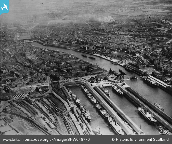
SPW048776 SCOTLAND (1935). Glasgow, general view, showing Queen's Dock and General Terminus Quay. An oblique aerial photograph taken facing south-east. This image has been produced from a print.
    © Hawlfraint cyfranwyr OpenStreetMap a thrwyddedwyd gan yr OpenStreetMap Foundation. 2025. Trwyddedir y gartograffeg fel CC BY-SA.
  
Delweddau cyfagos (9)
Manylion
| Pennawd | [SPW048776] Glasgow, general view, showing Queen's Dock and General Terminus Quay. An oblique aerial photograph taken facing south-east. This image has been produced from a print. | 
| Cyfeirnod | SPW048776 | 
| Dyddiad | 1935 | 
| Dolen | NRHE Collection item 1315584 | 
| Enw lle | |
| Plwyf | GLASGOW (CITY OF GLASGOW) | 
| Ardal | CITY OF GLASGOW | 
| Gwlad | SCOTLAND | 
| Dwyreiniad / Gogleddiad | 257450, 665100 | 
| Hydred / Lledred | -4.2777341316911, 55.858010176335 | 
| Cyfeirnod Grid Cenedlaethol | NS575651 | 
Pinnau
|  Seamen*s restaurant |   yes | Monday 6th of October 2025 04:44:40 PM | 
|  Kingston Dock |   yes | Monday 6th of October 2025 04:43:15 PM | 
|  This is the south terminal of the Finnieston Ferries {pedestrian and vehicular}  under construction. Due to the recent construction of the giant Stobcross crane it was moved  from just beside the crane upriver  to Elliot St  on the nortj bank. |   yes | Monday 6th of October 2025 04:41:56 PM | 
|  Mavisbank Quay |   yes | Monday 6th of October 2025 04:33:27 PM | 
|  Glasgow Harbour Tunnel Rotundas.
This is the North Rotunda located on Tunnel Street with the South Rotunda at Plantation Place.
The Glasgow Harbour Tunnel Rotundas are two iconic red brick stone buildings which flank the River Clyde in the Finnieston area.
Designed by Simpson and Wilson, and built between 1890 and 1896 by Glasgow Tunnel Company, the Rotunda covered 24-metre (79 ft) deep shafts to tunnels which enabled vehicular and pedestrian access to the other side of the river.
Pedestrians, horses and carts - and later motor vehicles - would be hauled up by hydraulic lifts provided by Otis Elevator Company of New York.
During the Second World War, the tunnels were temporarily closed because all the metal from the lifts was removed to contribute to the war effort.
The tunnels were an expensive venture to run and were passed to the council to run as a service in 1926.
The increased costs of running the tunnels which were prone to damp and the increase of motor cars on the roads lead to the closure of the pedestrian tunnel in 1980, and the vehicular tunnels being filled in 1986. Though the pedestrian tunnel still exists, it is closed to the public.
Originally, three-storey red and white brick towers stood alongside the Rotundas, containing the hydraulic accumulators that powered the lifts, but these have been demolished.
See South Rotunda below. |   Billy Turner | Tuesday 29th of November 2016 06:23:48 PM | 
|   Billy Turner | Tuesday 29th of November 2016 06:18:42 PM | 
 
             
  ![[SPW048776] Glasgow, general view, showing Queen's Dock and General Terminus Quay.  An oblique aerial photograph taken facing south-east.  This image has been produced from a print.](http://britainfromabove.org.uk/sites/all/libraries/aerofilms-images/public/100x100/SPW/048/SPW048776.jpg) 
  
                                          ![[SAW009728] Glasgow, general view, showing Harland and Wolff Diesel Engine Works, 181 Lancefield Street and Queen's Dock.  An oblique aerial photograph taken facing west.  This image has been produced from a crop marked negative.](http://britainfromabove.org.uk/sites/all/libraries/aerofilms-images/public/100x100/SAW/009/SAW009728.jpg) 
 ![[SAW028371] Arbuckle, Smith and Co. Warehouse, Lancefield Street, Glasgow.  An oblique aerial photograph taken facing north.  This image has been produced from a crop marked negative.](http://britainfromabove.org.uk/sites/all/libraries/aerofilms-images/public/100x100/SAW/028/SAW028371.jpg) 
 ![[SAW009736] Glasgow, general view, showing Harland and Wolff Diesel Engine Works, 181 Lancefield Street and Queen's Dock.  An oblique aerial photograph taken facing north-west.  This image has been produced from a crop marked negative.](http://britainfromabove.org.uk/sites/all/libraries/aerofilms-images/public/100x100/SAW/009/SAW009736.jpg) 
 ![[SAW028367] Glasgow, general view, showing Arbuckle, Smith and Co. Warehouse, Lancefield Street and Bilsland Bakery, Hydepark Street.  An oblique aerial photograph taken facing north-west.  This image has been produced from a crop marked negative.](http://britainfromabove.org.uk/sites/all/libraries/aerofilms-images/public/100x100/SAW/028/SAW028367.jpg) 
 ![[SAW028368] Glasgow, general view, showing Arbuckle, Smith and Co. Warehouse, Lancefield Street and Stobcross Street.  An oblique aerial photograph taken facing north.  This image has been produced from a crop marked negative.](http://britainfromabove.org.uk/sites/all/libraries/aerofilms-images/public/100x100/SAW/028/SAW028368.jpg) 
 ![[SAW028369] Arbuckle, Smith and Co. Warehouse, Lancefield Street and Bilsland Bakery, Hydepark Street, Glasgow.  An oblique aerial photograph taken facing east.  This image has been produced from a crop marked negative.](http://britainfromabove.org.uk/sites/all/libraries/aerofilms-images/public/100x100/SAW/028/SAW028369.jpg) 
 ![[SAW028370] Glasgow, general view, showing Arbuckle, Smith and Co. Warehouse, Lancefield Street and Stobcross Street.  An oblique aerial photograph taken facing east.  This image has been produced from a crop marked negative.](http://britainfromabove.org.uk/sites/all/libraries/aerofilms-images/public/100x100/SAW/028/SAW028370.jpg) 
 ![[SAW028372] Arbuckle, Smith and Co. Warehouse, Lancefield Street, Glasgow.  An oblique aerial photograph taken facing north-east.  This image has been produced from a crop marked negative.](http://britainfromabove.org.uk/sites/all/libraries/aerofilms-images/public/100x100/SAW/028/SAW028372.jpg) 
 
