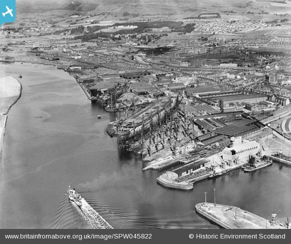
SPW045822 SCOTLAND (1934). Clydebank, general view, showing Forth and Clyde Canal and John Brown's Shipyard, Queen Mary under construction. An oblique aerial photograph taken facing north.
    © Hawlfraint cyfranwyr OpenStreetMap a thrwyddedwyd gan yr OpenStreetMap Foundation. 2025. Trwyddedir y gartograffeg fel CC BY-SA.
  
Delweddau cyfagos (17)
Manylion
| Pennawd | [SPW045822] Clydebank, general view, showing Forth and Clyde Canal and John Brown's Shipyard, Queen Mary under construction. An oblique aerial photograph taken facing north. | 
| Cyfeirnod | SPW045822 | 
| Dyddiad | 1934 | 
| Dolen | NRHE Collection item 1257672 | 
| Enw lle | |
| Plwyf | OLD KILPATRICK (CLYDEBANK) | 
| Ardal | CLYDEBANK | 
| Gwlad | SCOTLAND | 
| Dwyreiniad / Gogleddiad | 249485, 669758 | 
| Hydred / Lledred | -4.4074679137064, 55.897409755484 | 
| Cyfeirnod Grid Cenedlaethol | NS495698 | 
Pinnau
|  Clyde Navigation Trust Hailing Station. |   yes | Friday 20th of June 2025 09:13:09 AM | 
|  Radnor St j/w Kilbowie Rd |   yes | Thursday 6th of February 2025 05:48:55 PM | 
|  Slipways of former Beardmore Shipyard |   yes | Tuesday 27th of August 2024 09:31:29 AM | 
|  The High Park. Great view of shipping on the river from here. |   yes | Monday 26th of February 2024 02:20:27 PM | 
|  Rear view of The Crescent, a fine terrace of Town Houses destroyed during the Blitz. |   yes | Tuesday 12th of December 2023 08:49:50 AM | 
|  Post Office Cable Depot and Wharf |   yes | Monday 27th of November 2023 12:44:50 AM | 
|  Clyde Navigation Trust hopper barges. |   yes | Wednesday 1st of November 2023 09:04:48 AM | 
|  Williamson-Buchanan paddle steamer, possibly 'Eagle III'. |   mannidaze | Saturday 19th of January 2019 10:07:57 AM | 
|  clinker store |   Dylan Moore | Wednesday 12th of August 2015 10:35:17 PM | 
|  cement silos |   Dylan Moore | Wednesday 12th of August 2015 10:34:50 PM | 
|  Clyde Cement Works: a clinker grinding plant operated by Tunnel 1933-1967. The clinker mainly came by sea from West Thurrock. |   Dylan Moore | Wednesday 12th of August 2015 10:34:21 PM | 
|  Cunarder 534 - Queen Mary |   Coventry kid | Tuesday 12th of November 2013 10:58:06 PM | 
|  The "Holy City" - First, Second and Third Terrace |   Weechookieburdie | Friday 16th of August 2013 10:05:35 PM | 
|  The "Caley Bridge" - bridge over Dumbarton Road, carrying the Caledonian Railway Lanarkshire & Dunbartonshire Line from Kilbowie Station to Dalmuir Riverside Station (site now Golden Jubilee National Hospital and the Beardmore Hotel and Conference Centre.) |   Weechookieburdie | Friday 16th of August 2013 09:48:12 PM | 
|  Clydebank Town Hall |   Weechookieburdie | Friday 16th of August 2013 09:34:36 PM | 
|  Miller Street School |   Weechookieburdie | Friday 16th of August 2013 09:33:20 PM | 
|  Swing bridge over canal (Kilbowie Road) |   Weechookieburdie | Friday 16th of August 2013 09:32:41 PM | 
|  Clydebank Co-op Dairy |   Weechookieburdie | Friday 16th of August 2013 09:31:18 PM | 
|  Clydebank Co-op Central Warehouse. |   Weechookieburdie | Friday 16th of August 2013 09:30:48 PM | 
|  Clydebank Central Station. NB footpath leading down from station to Hume Street, still in use today. |   Weechookieburdie | Friday 16th of August 2013 09:30:08 PM | 
|  Titan Crane - now all that remains of John Brown's Shipbuilding Yard, now in use as a Visitor Attraction. |   Weechookieburdie | Friday 16th of August 2013 09:25:55 PM | 
Cyfraniadau Grŵp
| does anyone know the name of the paddle steamer passing John Browns? |   Alan Adams | Sunday 12th of August 2012 08:01:28 AM | 
 
             
  ![[SAR008774] John Brown's Yard, Clydebank Old Kilpatrick, Dunbartonshire, Scotland. An oblique aerial photograph taken facing North.](http://britainfromabove.org.uk/sites/all/libraries/aerofilms-images/public/100x100/SAR/008/SAR008774.jpg) 
  
                                          ![[SAW024758] John Brown and Co. Shipyard, Clydebank.  An oblique aerial photograph taken facing north-west.](http://britainfromabove.org.uk/sites/all/libraries/aerofilms-images/public/100x100/SAW/024/SAW024758.jpg) 
 ![[SPW045821] John Brown's Shipyard, Clydebank, Queen Mary under construction.  An oblique aerial photograph taken facing west.](http://britainfromabove.org.uk/sites/all/libraries/aerofilms-images/public/100x100/SPW/045/SPW045821.jpg) 
 ![[SPW045822] Clydebank, general view, showing Forth and Clyde Canal and John Brown's Shipyard, Queen Mary under construction.  An oblique aerial photograph taken facing north.](http://britainfromabove.org.uk/sites/all/libraries/aerofilms-images/public/100x100/SPW/045/SPW045822.jpg) 
 ![[SPW045823] John Brown's Shipyard, Clydebank, Queen Mary under construction.  An oblique aerial photograph taken facing north.](http://britainfromabove.org.uk/sites/all/libraries/aerofilms-images/public/100x100/SPW/045/SPW045823.jpg) 
 ![[SPW048769] John Brown's Shipyard, Clydebank, Queen Mary under construction.  An oblique aerial photograph taken facing east.](http://britainfromabove.org.uk/sites/all/libraries/aerofilms-images/public/100x100/SPW/048/SPW048769.jpg) 
 ![[SPW048770] John Brown's Shipyard, Clydebank, Queen Mary under construction.  An oblique aerial photograph taken facing east.  This image has been produced from a print.](http://britainfromabove.org.uk/sites/all/libraries/aerofilms-images/public/100x100/SPW/048/SPW048770.jpg) 
 ![[SPW048771] John Brown's Shipyard, Clydebank, Queen Mary under construction.  An oblique aerial photograph taken facing south-west.](http://britainfromabove.org.uk/sites/all/libraries/aerofilms-images/public/100x100/SPW/048/SPW048771.jpg) 
 ![[SPW053551] John Brown's Shipyard, Clydebank, Queen Elizabeth under construction.  An oblique aerial photograph taken facing north-west.  This image has been produced from a damaged print.](http://britainfromabove.org.uk/sites/all/libraries/aerofilms-images/public/100x100/SPW/053/SPW053551.jpg) 
 ![[SPW019475] John Brown and Co. shipyards, Clydebank.  An oblique aerial photograph taken facing east.](http://britainfromabove.org.uk/sites/all/libraries/aerofilms-images/public/100x100/SPW/019/SPW019475.jpg) 
 ![[SPW049784] Queen Mary, River Clyde, Clydebank.  An oblique aerial photograph taken facing south.](http://britainfromabove.org.uk/sites/all/libraries/aerofilms-images/public/100x100/SPW/049/SPW049784.jpg) 
 ![[SPW049785] Queen Mary, River Clyde, Clydebank.  An oblique aerial photograph taken facing north-west.](http://britainfromabove.org.uk/sites/all/libraries/aerofilms-images/public/100x100/SPW/049/SPW049785.jpg) 
 ![[SPW049793] Queen Mary, River Clyde, Clydebank.  An oblique aerial photograph taken facing south.](http://britainfromabove.org.uk/sites/all/libraries/aerofilms-images/public/100x100/SPW/049/SPW049793.jpg) 
 ![[SPW049799] Queen Mary, River Clyde, Clydebank.  An oblique aerial photograph taken facing south.  This image has been produced from a damaged negative.](http://britainfromabove.org.uk/sites/all/libraries/aerofilms-images/public/100x100/SPW/049/SPW049799.jpg) 
 ![[SPW053550] John Brown's Shipyard, Clydebank, Queen Elizabeth under construction.  An oblique aerial photograph taken facing north.  This image has been produced from a print.](http://britainfromabove.org.uk/sites/all/libraries/aerofilms-images/public/100x100/SPW/053/SPW053550.jpg) 
 ![[SPW045820] John Brown's Shipyard, Clydebank, Queen Mary under construction.  An oblique aerial photograph taken facing west.](http://britainfromabove.org.uk/sites/all/libraries/aerofilms-images/public/100x100/SPW/045/SPW045820.jpg) 
 ![[SPW050839] Glasgow, general view, showing Rothesay Dock and Newshot Island.  An oblique aerial photograph taken facing north.  This image has been produced from a damaged negative.](http://britainfromabove.org.uk/sites/all/libraries/aerofilms-images/public/100x100/SPW/050/SPW050839.jpg)