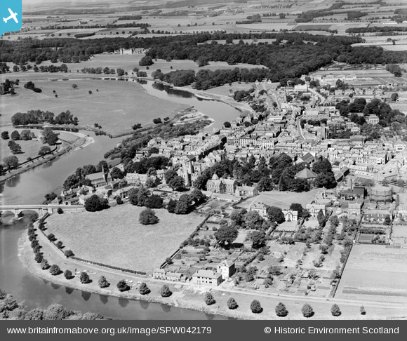
SPW042179 SCOTLAND (1933). Kelso, general view, showing Old Parish Church and Bowmont Street. An oblique aerial photograph taken facing north-west.
© Hawlfraint cyfranwyr OpenStreetMap a thrwyddedwyd gan yr OpenStreetMap Foundation. 2026. Trwyddedir y gartograffeg fel CC BY-SA.
Delweddau cyfagos (10)
Manylion
| Pennawd | [SPW042179] Kelso, general view, showing Old Parish Church and Bowmont Street. An oblique aerial photograph taken facing north-west. |
| Cyfeirnod | SPW042179 |
| Dyddiad | 1933 |
| Dolen | NRHE Collection item 1257576 |
| Enw lle | |
| Plwyf | KELSO |
| Ardal | ROXBURGH |
| Gwlad | SCOTLAND |
| Dwyreiniad / Gogleddiad | 372801, 633852 |
| Hydred / Lledred | -2.4316748027059, 55.597529466674 |
| Cyfeirnod Grid Cenedlaethol | NT728339 |
Pinnau

Scott |
Tuesday 6th of April 2021 10:02:54 PM | |

Learning2Fly |
Tuesday 3rd of May 2016 03:32:05 AM | |

Learning2Fly |
Tuesday 3rd of May 2016 03:29:51 AM | |

Learning2Fly |
Tuesday 3rd of May 2016 03:28:12 AM | |

Learning2Fly |
Tuesday 3rd of May 2016 03:24:59 AM |


![[SPW042179] Kelso, general view, showing Old Parish Church and Bowmont Street. An oblique aerial photograph taken facing north-west.](http://britainfromabove.org.uk/sites/all/libraries/aerofilms-images/public/100x100/SPW/042/SPW042179.jpg)
![[SPW042178] Kelso, general view, showing Kelso Bridge and United Presbyterian Church, East Bowmont Street. An oblique aerial photograph taken facing north.](http://britainfromabove.org.uk/sites/all/libraries/aerofilms-images/public/100x100/SPW/042/SPW042178.jpg)
![[SPW042182] Kelso, general view, showing Kelso Abbey and The Square. An oblique aerial photograph taken facing north-west.](http://britainfromabove.org.uk/sites/all/libraries/aerofilms-images/public/100x100/SPW/042/SPW042182.jpg)
![[SPW042181] Kelso Abbey. An oblique aerial photograph taken facing north.](http://britainfromabove.org.uk/sites/all/libraries/aerofilms-images/public/100x100/SPW/042/SPW042181.jpg)
![[SAW016842] Kelso, general view, showing Roxburgh Street and Wood Market. An oblique aerial photograph taken facing east.](http://britainfromabove.org.uk/sites/all/libraries/aerofilms-images/public/100x100/SAW/016/SAW016842.jpg)
![[SPW042180] Kelso, general view, showing Kelso Bridge and Bowmont Street. An oblique aerial photograph taken facing north.](http://britainfromabove.org.uk/sites/all/libraries/aerofilms-images/public/100x100/SPW/042/SPW042180.jpg)
![[SAR035975] General View Kelso, Roxburghshire, Scotland. An oblique aerial photograph taken facing North/West.](http://britainfromabove.org.uk/sites/all/libraries/aerofilms-images/public/100x100/SAR/035/SAR035975.jpg)
![[SAW016840] Kelso, general view, showing Kelso Bridge and The Square. An oblique aerial photograph taken facing north-east.](http://britainfromabove.org.uk/sites/all/libraries/aerofilms-images/public/100x100/SAW/016/SAW016840.jpg)
![[SAW016843] Kelso, general view, showing Kelso Bridge and Roxburgh Street. An oblique aerial photograph taken facing south-east.](http://britainfromabove.org.uk/sites/all/libraries/aerofilms-images/public/100x100/SAW/016/SAW016843.jpg)
![[SAW016841] Kelso, general view, showing Kelso Anna and Roxburgh Street. An oblique aerial photograph taken facing east.](http://britainfromabove.org.uk/sites/all/libraries/aerofilms-images/public/100x100/SAW/016/SAW016841.jpg)