
SPW040559 SCOTLAND (1932). Stannergate Power Station and Caledon Shipyard, Stannergate Road, Dundee. An oblique aerial photograph taken facing east. This image has been produced from a print.

© Hawlfraint cyfranwyr OpenStreetMap a thrwyddedwyd gan yr OpenStreetMap Foundation. 2026. Trwyddedir y gartograffeg fel CC BY-SA.
Delweddau cyfagos (3)
SPW022105

SPW040559

SPW040560

Manylion
| Pennawd | [SPW040559] Stannergate Power Station and Caledon Shipyard, Stannergate Road, Dundee. An oblique aerial photograph taken facing east. This image has been produced from a print. |
| Cyfeirnod | SPW040559 |
| Dyddiad | 1932 |
| Dolen | NRHE Collection item 1315550 |
| Enw lle | |
| Plwyf | DUNDEE (DUNDEE, CITY OF) |
| Ardal | CITY OF DUNDEE |
| Gwlad | SCOTLAND |
| Dwyreiniad / Gogleddiad | 342409, 730911 |
| Hydred / Lledred | -2.934816129908, 56.466913136124 |
| Cyfeirnod Grid Cenedlaethol | NO424309 |
Pinnau
Byddwch y cyntaf i ychwanegu sylw at y ddelwedd hon!
Cyfraniadau Grŵp
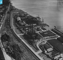
Stannergate Power Station also known as Caroline Port A, built by Dundee Corporation, opened 1909, taken over by the NSHEB in 1947, closed in 1960s?. Caroline Port B was built adjacent to this site. |

cell |
Sunday 5th of May 2013 04:45:20 PM |