
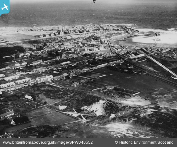
SPW040552 SCOTLAND (1932). Lossiemouth, general view, showing Moray Street and Prospect Terrace. An oblique aerial photograph taken facing north-east. This image has been produced from a print.
© Hawlfraint cyfranwyr OpenStreetMap a thrwyddedwyd gan yr OpenStreetMap Foundation. 2026. Trwyddedir y gartograffeg fel CC BY-SA.
Delweddau cyfagos (6)
SPW040552

SAR016746

SAR023868

SAR023870

SAR033425

SAR033426

Manylion
| Pennawd | [SPW040552] Lossiemouth, general view, showing Moray Street and Prospect Terrace. An oblique aerial photograph taken facing north-east. This image has been produced from a print. |
| Cyfeirnod | SPW040552 |
| Dyddiad | 1932 |
| Dolen | NRHE Collection item 1315543 |
| Enw lle | |
| Plwyf | DRAINIE |
| Ardal | MORAY |
| Gwlad | SCOTLAND |
| Dwyreiniad / Gogleddiad | 323576, 870383 |
| Hydred / Lledred | -3.2829935059871, 57.716971709427 |
| Cyfeirnod Grid Cenedlaethol | NJ236704 |
Pinnau

Chris Souter |
Friday 17th of May 2024 02:38:17 PM | |
|
cell |
Sunday 23rd of June 2013 04:44:27 PM |
Cyfraniadau Grŵp

Lossiemouth Power Station built by the Lossiemouth and Branderburgh Corporation Current Owner/ Owner at Close: NSHEB Gen Start Date: 1914 Gen Stop Date: 1951 Demolished: N/A Station Size MW: 0.258 |
cell |
Sunday 23rd of June 2013 04:47:32 PM |