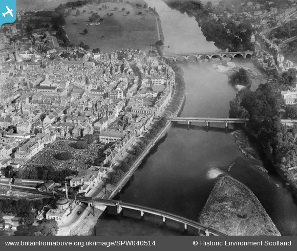
SPW040514 SCOTLAND (1932). Perth, general view, showing the Bridges and St John's Kirk of Perth. An oblique aerial photograph taken facing north.
© Hawlfraint cyfranwyr OpenStreetMap a thrwyddedwyd gan yr OpenStreetMap Foundation. 2026. Trwyddedir y gartograffeg fel CC BY-SA.
Delweddau cyfagos (11)
Manylion
| Pennawd | [SPW040514] Perth, general view, showing the Bridges and St John's Kirk of Perth. An oblique aerial photograph taken facing north. |
| Cyfeirnod | SPW040514 |
| Dyddiad | 1932 |
| Dolen | NRHE Collection item 1257545 |
| Enw lle | |
| Plwyf | PERTH |
| Ardal | PERTH AND KINROSS |
| Gwlad | SCOTLAND |
| Dwyreiniad / Gogleddiad | 312077, 723457 |
| Hydred / Lledred | -3.4245159924797, 56.395276889384 |
| Cyfeirnod Grid Cenedlaethol | NO121235 |
Pinnau
Byddwch y cyntaf i ychwanegu sylw at y ddelwedd hon!
Cyfraniadau Grŵp

heavenstobetsie |
Tuesday 26th of June 2012 09:08:03 AM |


![[SPW040514] Perth, general view, showing the Bridges and St John's Kirk of Perth. An oblique aerial photograph taken facing north.](http://britainfromabove.org.uk/sites/all/libraries/aerofilms-images/public/100x100/SPW/040/SPW040514.jpg)
![[SPW040515] Perth, general view, showing the Bridges and North Inch Golf Course. An oblique aerial photograph taken facing north.](http://britainfromabove.org.uk/sites/all/libraries/aerofilms-images/public/100x100/SPW/040/SPW040515.jpg)
![[SAW022530] Perth, general view, showing Salutation Hotel, South Street and Queen's Bridge. An oblique aerial photograph taken facing south-east. This image has been produced from a crop marked negative.](http://britainfromabove.org.uk/sites/all/libraries/aerofilms-images/public/100x100/SAW/022/SAW022530.jpg)
![[SAW022532] Salutation Hotel, South Street and Greyfriars Burial Ground, Perth. An oblique aerial photograph taken facing south. This image has been produced from a crop marked negative.](http://britainfromabove.org.uk/sites/all/libraries/aerofilms-images/public/100x100/SAW/022/SAW022532.jpg)
![[SAW022533] Perth, general view, showing Salutation Hotel, South Street and West Railway Bridge. An oblique aerial photograph taken facing south-east.](http://britainfromabove.org.uk/sites/all/libraries/aerofilms-images/public/100x100/SAW/022/SAW022533.jpg)
![[SAW022531] Perth, general view, showing Salutation Hotel, South Street and Queen's Bridge. An oblique aerial photograph taken facing east. This image has been produced from a crop marked negative.](http://britainfromabove.org.uk/sites/all/libraries/aerofilms-images/public/100x100/SAW/022/SAW022531.jpg)
![[SPW020124] Perth, general view, showing Queen's Bridge, St Matthew's Church and Greyfriars Burial Ground. An oblique aerial photograph taken facing north-east.](http://britainfromabove.org.uk/sites/all/libraries/aerofilms-images/public/100x100/SPW/020/SPW020124.jpg)
![[SPW020126] Perth, general view, showing Perth Bridge, Queen's Bridge and St Matthew's Church. An oblique aerial photograph taken facing north-east.](http://britainfromabove.org.uk/sites/all/libraries/aerofilms-images/public/100x100/SPW/020/SPW020126.jpg)
![[SAW022534] Salutation Hotel, South Street and Greyfriars Burial Ground, Perth. An oblique aerial photograph taken facing south. This image has been produced from a crop marked negative.](http://britainfromabove.org.uk/sites/all/libraries/aerofilms-images/public/100x100/SAW/022/SAW022534.jpg)
![[SAW022536] Salutation Hotel, South Street and Greyfriars Burial Ground, Perth. An oblique aerial photograph taken facing south. This image has been produced from a crop marked negative.](http://britainfromabove.org.uk/sites/all/libraries/aerofilms-images/public/100x100/SAW/022/SAW022536.jpg)
![[SAW022535] Perth, general view, showing Salutation Hotel, South Street and West Railway Bridge. An oblique aerial photograph taken facing south. This image has been produced from a crop marked negative.](http://britainfromabove.org.uk/sites/all/libraries/aerofilms-images/public/100x100/SAW/022/SAW022535.jpg)
