
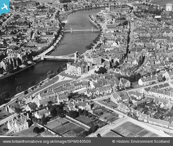
SPW040500 SCOTLAND (1932). Inverness, general view, showing Castle Hill and Church Street. An oblique aerial photograph taken facing north. This image has been produced from a print.
© Hawlfraint cyfranwyr OpenStreetMap a thrwyddedwyd gan yr OpenStreetMap Foundation. 2026. Trwyddedir y gartograffeg fel CC BY-SA.
Delweddau cyfagos (13)
SPW040500

SPW022148

SPW022146

SAW003579

SPW022144

SPW022149

SPW033826

SPW040498

SPW040499

SPW033829

SPW033833

SPW022145

SPW033825

Manylion
| Pennawd | [SPW040500] Inverness, general view, showing Castle Hill and Church Street. An oblique aerial photograph taken facing north. This image has been produced from a print. |
| Cyfeirnod | SPW040500 |
| Dyddiad | 1932 |
| Dolen | NRHE Collection item 1315511 |
| Enw lle | |
| Plwyf | INVERNESS AND BONA |
| Ardal | INVERNESS |
| Gwlad | SCOTLAND |
| Dwyreiniad / Gogleddiad | 266647, 845065 |
| Hydred / Lledred | -4.2241323111949, 57.476418943468 |
| Cyfeirnod Grid Cenedlaethol | NH666451 |
Pinnau

oldhall |
Monday 4th of November 2013 04:09:24 PM |
Cyfraniadau Grŵp
This is an important shot, since it was taken barely a fortnight before the landslide of 8th October 1932, which led to the demolition of nearly all the western side of Castle Street, facing the camera here. |
oldhall |
Friday 20th of December 2013 01:35:45 PM |