
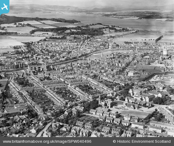
SPW040496 SCOTLAND (1932). Inverness, general view, showing Kingsmill Road, Inverness Castle and River Ness. An oblique aerial photograph taken facing west.
© Hawlfraint cyfranwyr OpenStreetMap a thrwyddedwyd gan yr OpenStreetMap Foundation. 2026. Trwyddedir y gartograffeg fel CC BY-SA.
Delweddau cyfagos (19)
SPW040496

SAW022602

SAW022603

SAW022610

SAW022604

SAR016705

SAW022605

SAW022608

SAW022609

SAW022606

SAW022607

SPW022140

SPW040499

SPW022147

SPW033826

SPW022149

SAW019890

SPW022139

SAW019891

Manylion
| Pennawd | [SPW040496] Inverness, general view, showing Kingsmill Road, Inverness Castle and River Ness. An oblique aerial photograph taken facing west. |
| Cyfeirnod | SPW040496 |
| Dyddiad | 1932 |
| Dolen | NRHE Collection item 1257532 |
| Enw lle | |
| Plwyf | INVERNESS AND BONA |
| Ardal | INVERNESS |
| Gwlad | SCOTLAND |
| Dwyreiniad / Gogleddiad | 266620, 845371 |
| Hydred / Lledred | -4.2247492782461, 57.47915791751 |
| Cyfeirnod Grid Cenedlaethol | NH666454 |
Pinnau
Cyfraniadau Grŵp
"Kingsmills" Road, with an 's' at the end! Fantastic picture though. I can recognise my old school (the Academy) but what is the bif square-ish building nearer the town centre, I wonder? |

Thorfinn |
Tuesday 26th of June 2012 10:42:02 AM |