
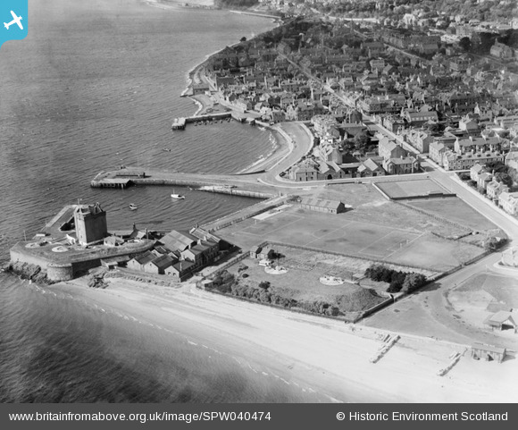
SPW040474 SCOTLAND (1932). Broughty Ferry, general view, showing King Street, Broughty Ferry Harbour and Broughty Castle. An oblique aerial photograph taken facing north-west.
© Hawlfraint cyfranwyr OpenStreetMap a thrwyddedwyd gan yr OpenStreetMap Foundation. 2026. Trwyddedir y gartograffeg fel CC BY-SA.
Delweddau cyfagos (5)
SPW040474

SPW040475

SPW019955

SPW019954

SPW019951

Manylion
| Pennawd | [SPW040474] Broughty Ferry, general view, showing King Street, Broughty Ferry Harbour and Broughty Castle. An oblique aerial photograph taken facing north-west. |
| Cyfeirnod | SPW040474 |
| Dyddiad | 1932 |
| Dolen | NRHE Collection item 1257505 |
| Enw lle | |
| Plwyf | DUNDEE (DUNDEE, CITY OF) |
| Ardal | CITY OF DUNDEE |
| Gwlad | SCOTLAND |
| Dwyreiniad / Gogleddiad | 346430, 730570 |
| Hydred / Lledred | -2.8694861276592, 56.46432377106 |
| Cyfeirnod Grid Cenedlaethol | NO464306 |
Pinnau
Cyfraniadau Grŵp
According to an entry in Wikipedia Broughty Castle was completed in 1495 and was retained as an active part of Britain's coastal defences until 1932, the year this aerial shot was taken |

MB |
Tuesday 10th of December 2013 10:16:03 AM |