
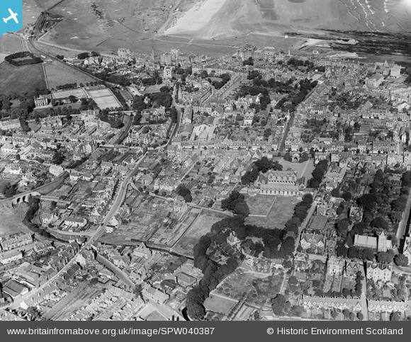
SPW040387 SCOTLAND (1932). St Andrews, general view, showing Madras College and City Road. An oblique aerial photograph taken facing north.
© Hawlfraint cyfranwyr OpenStreetMap a thrwyddedwyd gan yr OpenStreetMap Foundation. 2026. Trwyddedir y gartograffeg fel CC BY-SA.
Delweddau cyfagos (5)
SPW040387

SAW009808

SPW040388

SAW009812

SAW032131

Manylion
| Pennawd | [SPW040387] St Andrews, general view, showing Madras College and City Road. An oblique aerial photograph taken facing north. |
| Cyfeirnod | SPW040387 |
| Dyddiad | 1932 |
| Dolen | NRHE Collection item 1257454 |
| Enw lle | |
| Plwyf | ST ANDREWS AND ST LEONARDS |
| Ardal | NORTH EAST FIFE |
| Gwlad | SCOTLAND |
| Dwyreiniad / Gogleddiad | 350663, 716543 |
| Hydred / Lledred | -2.7981473093929, 56.338763262737 |
| Cyfeirnod Grid Cenedlaethol | NO507165 |
Pinnau

Andy A |
Tuesday 7th of January 2014 11:44:43 AM | |
|
Andy A |
Tuesday 7th of January 2014 11:44:25 AM |