
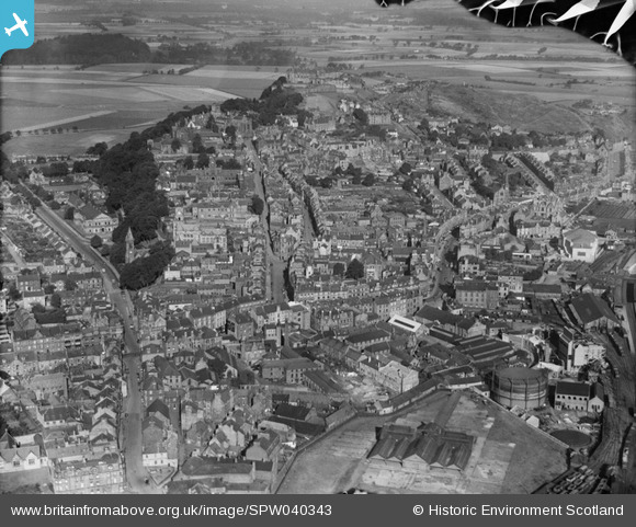
SPW040343 SCOTLAND (1932). Stirling, general view, showing Spittal Street and Stirling Castle. An oblique aerial photograph taken facing north-west. This image has been produced from a damaged negative.
© Hawlfraint cyfranwyr OpenStreetMap a thrwyddedwyd gan yr OpenStreetMap Foundation. 2026. Trwyddedir y gartograffeg fel CC BY-SA.
Delweddau cyfagos (13)
SPW040343

SPW040342

SPW020257

SPW020316

SAR008641

SAR008642

SAR008643

SAR018751

SAR019988

SAR023761

SPW020255

SPW040346

SPW020253

Manylion
| Pennawd | [SPW040343] Stirling, general view, showing Spittal Street and Stirling Castle. An oblique aerial photograph taken facing north-west. This image has been produced from a damaged negative. |
| Cyfeirnod | SPW040343 |
| Dyddiad | 1932 |
| Dolen | NRHE Collection item 1257400 |
| Enw lle | |
| Plwyf | STIRLING |
| Ardal | STIRLING |
| Gwlad | SCOTLAND |
| Dwyreiniad / Gogleddiad | 279587, 693466 |
| Hydred / Lledred | -3.9369630248257, 56.118791509775 |
| Cyfeirnod Grid Cenedlaethol | NS796935 |
Pinnau
Lynda Tubbs |
Tuesday 8th of July 2014 02:07:31 PM |
Cyfraniadau Grŵp

Built as the HQ of the Argyll and Sutherland Highlanders' 4th Volunteer Battalion in a vigorous Scots baronial style with twin towers. (McKean) |
Lynda Tubbs |
Tuesday 8th of July 2014 02:08:06 PM |