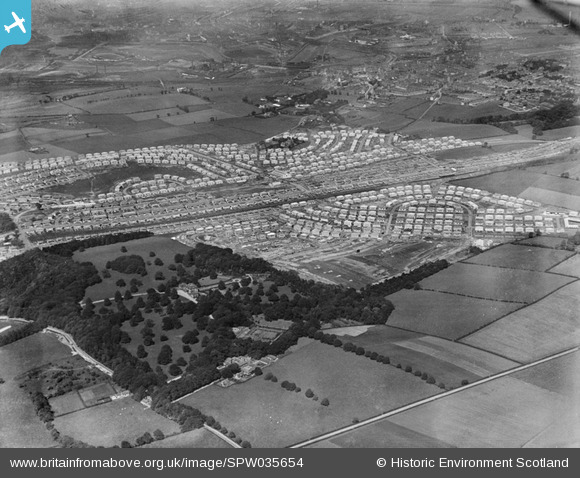
SPW035654 SCOTLAND (1931). King's Park and Croftfoot Housing Estates and King's Park, Glasgow. An oblique aerial photograph taken facing north.
© Hawlfraint cyfranwyr OpenStreetMap a thrwyddedwyd gan yr OpenStreetMap Foundation. 2026. Trwyddedir y gartograffeg fel CC BY-SA.
Manylion
| Pennawd | [SPW035654] King's Park and Croftfoot Housing Estates and King's Park, Glasgow. An oblique aerial photograph taken facing north. |
| Cyfeirnod | SPW035654 |
| Dyddiad | 1931 |
| Dolen | NRHE Collection item 1259441 |
| Enw lle | |
| Plwyf | CATHCART (CITY OF GLASGOW) |
| Ardal | CITY OF GLASGOW |
| Gwlad | SCOTLAND |
| Dwyreiniad / Gogleddiad | 260053, 660341 |
| Hydred / Lledred | -4.2337258415783, 55.816040809979 |
| Cyfeirnod Grid Cenedlaethol | NS601603 |
Pinnau

Alistair Munro |
Wednesday 24th of August 2022 04:28:05 PM | |

navaho56 |
Friday 23rd of March 2018 02:58:48 PM | |

paulmck1888 |
Wednesday 24th of September 2014 01:03:47 PM | |

paulmck1888 |
Wednesday 24th of September 2014 01:01:01 PM | |

paulmck1888 |
Wednesday 24th of September 2014 01:00:32 PM | |

paulmck1888 |
Wednesday 24th of September 2014 12:59:56 PM | |

paulmck1888 |
Wednesday 24th of September 2014 12:59:03 PM | |

BobbyS |
Sunday 17th of November 2013 05:54:37 PM | |

BobbyS |
Sunday 17th of November 2013 05:51:25 PM | |

BobbyS |
Sunday 17th of November 2013 05:50:36 PM | |

BobbyS |
Sunday 17th of November 2013 05:49:58 PM |


![[SPW035654] King's Park and Croftfoot Housing Estates and King's Park, Glasgow. An oblique aerial photograph taken facing north.](http://britainfromabove.org.uk/sites/all/libraries/aerofilms-images/public/100x100/SPW/035/SPW035654.jpg)
![[SPW035651] King's Park and Croftfoot Housing Estates, Glasgow. An oblique aerial photograph taken facing north.](http://britainfromabove.org.uk/sites/all/libraries/aerofilms-images/public/100x100/SPW/035/SPW035651.jpg)
![[SPW035652] King's Park and Croftfoot Housing Estates, Glasgow. An oblique aerial photograph taken facing north.](http://britainfromabove.org.uk/sites/all/libraries/aerofilms-images/public/100x100/SPW/035/SPW035652.jpg)
