
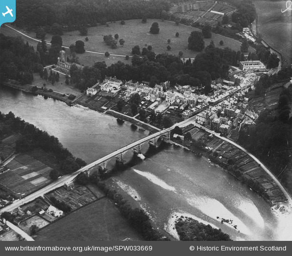
SPW033669 SCOTLAND (1930). Dunkeld, general view, showing Dunkeld Bridge and Cathedral. An oblique aerial photograph taken facing north-west. This image has been produced from a damaged print.
© Hawlfraint cyfranwyr OpenStreetMap a thrwyddedwyd gan yr OpenStreetMap Foundation. 2026. Trwyddedir y gartograffeg fel CC BY-SA.
Delweddau cyfagos (14)
SPW033669

SAR016728

SAR016729

SAR016730

SPW033672

SPW040524

SPW040523

SPW033668

SPW040526

SAR016726

SAR016727

SPW033667

SPW033671

SPW040522

Manylion
| Pennawd | [SPW033669] Dunkeld, general view, showing Dunkeld Bridge and Cathedral. An oblique aerial photograph taken facing north-west. This image has been produced from a damaged print. |
| Cyfeirnod | SPW033669 |
| Dyddiad | 1930 |
| Dolen | NRHE Collection item 1315492 |
| Enw lle | |
| Plwyf | DUNKELD AND DOWALLY |
| Ardal | PERTH AND KINROSS |
| Gwlad | SCOTLAND |
| Dwyreiniad / Gogleddiad | 302598, 742623 |
| Hydred / Lledred | -3.5851916787013, 56.565560236646 |
| Cyfeirnod Grid Cenedlaethol | NO026426 |
Pinnau
Byddwch y cyntaf i ychwanegu sylw at y ddelwedd hon!