
SPW027440 SCOTLAND (1929). Gretna, general view, showing Annan Road and Union Road. An oblique aerial photograph taken facing north. This image has been produced from a damaged negative.

© Hawlfraint cyfranwyr OpenStreetMap a thrwyddedwyd gan yr OpenStreetMap Foundation. 2026. Trwyddedir y gartograffeg fel CC BY-SA.
Delweddau cyfagos (3)
SPW027440

SPW027442

SPW027435

Manylion
| Pennawd | [SPW027440] Gretna, general view, showing Annan Road and Union Road. An oblique aerial photograph taken facing north. This image has been produced from a damaged negative. |
| Cyfeirnod | SPW027440 |
| Dyddiad | 1929 |
| Dolen | NRHE Collection item 1256881 |
| Enw lle | |
| Plwyf | GRETNA |
| Ardal | ANNANDALE AND ESKDALE |
| Gwlad | SCOTLAND |
| Dwyreiniad / Gogleddiad | 331754, 567303 |
| Hydred / Lledred | -3.0668744698319, 54.995550525483 |
| Cyfeirnod Grid Cenedlaethol | NY318673 |
Pinnau

Cyfraniadau Grŵp
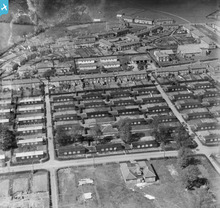
Gretna was the site of a munitions factory on the Solway Firth and the new township was built very quickly to house the workers. Find an fascinating guide here - http://www.historic-scotland.gov.uk/gretna |
Lynda Tubbs |
Thursday 10th of July 2014 03:04:05 PM |
Shows munitions workers housing. Find a guide to this fascinating development at http://www.historic-scotland.gov.uk/gretna |
Lynda Tubbs |
Thursday 10th of July 2014 02:57:47 PM |