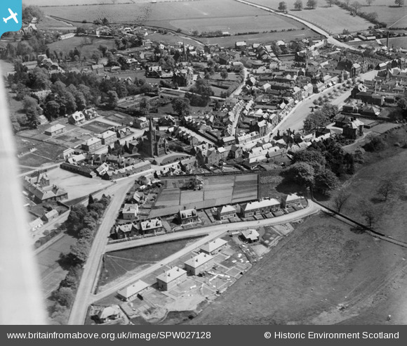
SPW027128 SCOTLAND (1929). Moffat, general view, showing High Street and St Mary's Church. An oblique aerial photograph taken facing south-east.
    © Hawlfraint cyfranwyr OpenStreetMap a thrwyddedwyd gan yr OpenStreetMap Foundation. 2025. Trwyddedir y gartograffeg fel CC BY-SA.
  
Manylion
| Pennawd | [SPW027128] Moffat, general view, showing High Street and St Mary's Church. An oblique aerial photograph taken facing south-east. | 
| Cyfeirnod | SPW027128 | 
| Dyddiad | 1929 | 
| Dolen | NRHE Collection item 1256647 | 
| Enw lle | |
| Plwyf | MOFFAT | 
| Ardal | ANNANDALE AND ESKDALE | 
| Gwlad | SCOTLAND | 
| Dwyreiniad / Gogleddiad | 308387, 605518 | 
| Hydred / Lledred | -3.4444133187954, 55.33512875725 | 
| Cyfeirnod Grid Cenedlaethol | NT084055 | 
Pinnau
Byddwch y cyntaf i ychwanegu sylw at y ddelwedd hon!
 
             
  ![[SPW027128] Moffat, general view, showing High Street and St Mary's Church.  An oblique aerial photograph taken facing south-east.](http://britainfromabove.org.uk/sites/all/libraries/aerofilms-images/public/100x100/SPW/027/SPW027128.jpg) 
  
                                          ![[SPW027126] Moffat, general view, showing High Street and Beechgrove.  An oblique aerial photograph taken facing north.](http://britainfromabove.org.uk/sites/all/libraries/aerofilms-images/public/100x100/SPW/027/SPW027126.jpg) 
 ![[SPW027127] Moffat, general view, showing High Street and Eastgate.  An oblique aerial photograph taken facing east.](http://britainfromabove.org.uk/sites/all/libraries/aerofilms-images/public/100x100/SPW/027/SPW027127.jpg) 
 ![[SPW027124] Moffat, general view, showing High Street and Burnside.  An oblique aerial photograph taken facing north-west.](http://britainfromabove.org.uk/sites/all/libraries/aerofilms-images/public/100x100/SPW/027/SPW027124.jpg)