
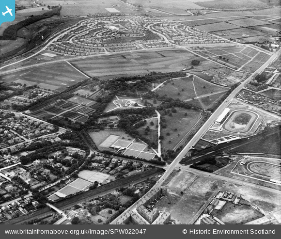
SPW022047 SCOTLAND (1928). Glasgow, general view, showing Bellahouston Park and White City Sports Ground. An oblique aerial photograph taken facing south-west.
© Hawlfraint cyfranwyr OpenStreetMap a thrwyddedwyd gan yr OpenStreetMap Foundation. 2026. Trwyddedir y gartograffeg fel CC BY-SA.
Delweddau cyfagos (7)
SPW022045

SPW022047

SPW056856

SPW022187

SPW056855

SPW022176

SPW020640

Manylion
| Pennawd | [SPW022047] Glasgow, general view, showing Bellahouston Park and White City Sports Ground. An oblique aerial photograph taken facing south-west. |
| Cyfeirnod | SPW022047 |
| Dyddiad | 1928 |
| Dolen | NRHE Collection item 1256434 |
| Enw lle | |
| Plwyf | GOVAN (CITY OF GLASGOW) |
| Ardal | CITY OF GLASGOW |
| Gwlad | SCOTLAND |
| Dwyreiniad / Gogleddiad | 255220, 663990 |
| Hydred / Lledred | -4.3127415270451, 55.847379597229 |
| Cyfeirnod Grid Cenedlaethol | NS552640 |
Pinnau

gBr |
Friday 26th of December 2014 01:57:49 AM | |
|
gedboy |
Saturday 29th of December 2012 08:26:48 PM | |

Class31 |
Monday 3rd of December 2012 04:35:15 PM | |
|
Class31 |
Monday 3rd of December 2012 04:34:04 PM | |
|
Class31 |
Monday 3rd of December 2012 04:33:37 PM | |
|
Class31 |
Monday 3rd of December 2012 04:21:30 PM | |
|
Class31 |
Monday 3rd of December 2012 04:21:01 PM | |
|
Class31 |
Monday 3rd of December 2012 04:20:28 PM | |
|
mannidaze |
Saturday 25th of August 2012 05:06:06 PM |