
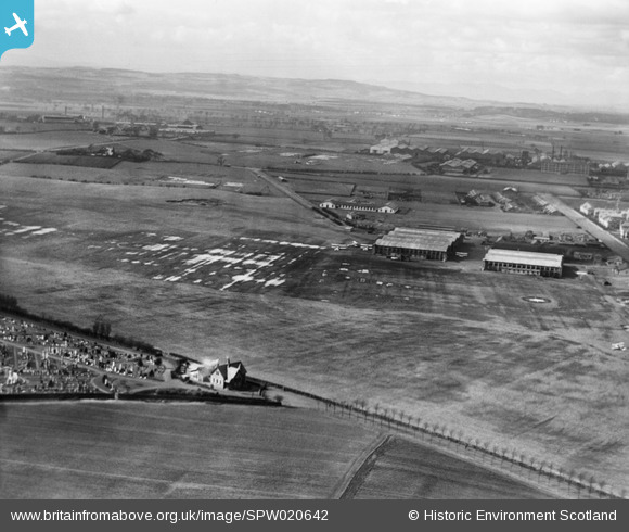
SPW020642 SCOTLAND (1928). Moor Park Aerodrome, Renfrew. An oblique aerial photograph taken facing north-west.
© Hawlfraint cyfranwyr OpenStreetMap a thrwyddedwyd gan yr OpenStreetMap Foundation. 2026. Trwyddedir y gartograffeg fel CC BY-SA.
Delweddau cyfagos (4)
SPW020642

SPW020700

SPW027314

SPW049806

Manylion
| Pennawd | [SPW020642] Moor Park Aerodrome, Renfrew. An oblique aerial photograph taken facing north-west. |
| Cyfeirnod | SPW020642 |
| Dyddiad | 1928 |
| Dolen | NRHE Collection item 1256401 |
| Enw lle | |
| Plwyf | RENFREW (RENFREW) |
| Ardal | RENFREW |
| Gwlad | SCOTLAND |
| Dwyreiniad / Gogleddiad | 250400, 665880 |
| Hydred / Lledred | -4.3907051786798, 55.862877842206 |
| Cyfeirnod Grid Cenedlaethol | NS504659 |
Pinnau

lewis143@btinternet.com |
Saturday 11th of October 2014 11:34:37 PM | |
|
lewis143@btinternet.com |
Saturday 11th of October 2014 11:32:53 PM | |
Newmains Road rather than Broadloan |
perrytheplatypus |
Wednesday 3rd of June 2015 08:10:27 PM |
|
lewis143@btinternet.com |
Saturday 5th of April 2014 10:44:30 PM |
Cyfraniadau Grŵp
Could this be the Renfrew WW1 Air Station? |
Lynda Tubbs |
Wednesday 25th of June 2014 03:33:57 PM |