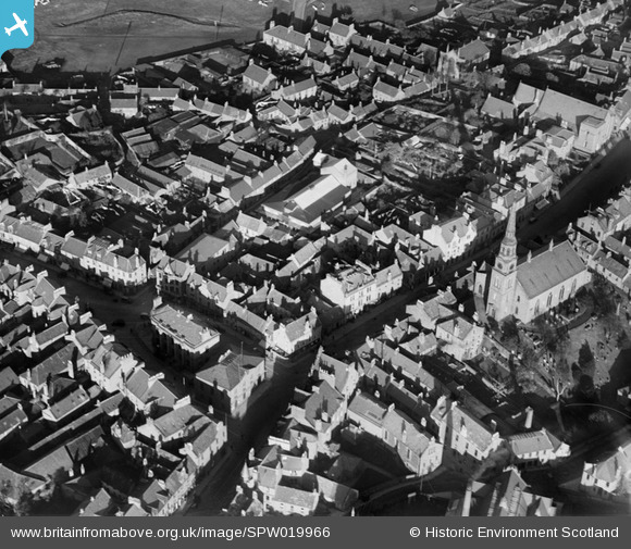
SPW019966 SCOTLAND (1927). Forfar, general view, showing East High Street with Forfar Parish Church and Town Hall. An oblique aerial photograph taken facing north-east.
    © Hawlfraint cyfranwyr OpenStreetMap a thrwyddedwyd gan yr OpenStreetMap Foundation. 2025. Trwyddedir y gartograffeg fel CC BY-SA.
  
Delweddau cyfagos (7)
Manylion
| Pennawd | [SPW019966] Forfar, general view, showing East High Street with Forfar Parish Church and Town Hall. An oblique aerial photograph taken facing north-east. | 
| Cyfeirnod | SPW019966 | 
| Dyddiad | 1927 | 
| Dolen | NRHE Collection item 1246368 | 
| Enw lle | |
| Plwyf | FORFAR | 
| Ardal | ANGUS | 
| Gwlad | SCOTLAND | 
| Dwyreiniad / Gogleddiad | 345677, 750656 | 
| Hydred / Lledred | -2.8859122089589, 56.64468761822 | 
| Cyfeirnod Grid Cenedlaethol | NO457507 | 
Pinnau
Byddwch y cyntaf i ychwanegu sylw at y ddelwedd hon!
 
             
  ![[SPW019966] Forfar, general view, showing East High Street with Forfar Parish Church and Town Hall.  An oblique aerial photograph taken facing north-east.](http://britainfromabove.org.uk/sites/all/libraries/aerofilms-images/public/100x100/SPW/019/SPW019966.jpg) 
  
                                          ![[SAR023882] General View Forfar, Angus, Scotland. An oblique aerial photograph taken facing North. This image was marked by AeroPictorial Ltd for photo editing.](http://britainfromabove.org.uk/sites/all/libraries/aerofilms-images/public/100x100/SAR/023/SAR023882.jpg) 
 ![[SPW019987] Forfar, general view, showing Town Hall and West High Street.  An oblique aerial photograph taken facing north.](http://britainfromabove.org.uk/sites/all/libraries/aerofilms-images/public/100x100/SPW/019/SPW019987.jpg) 
 ![[SAW035393] Forfar, general view.  An oblique aerial photograph taken facing north.  This image has been produced from a print.](http://britainfromabove.org.uk/sites/all/libraries/aerofilms-images/public/100x100/SAW/035/SAW035393.jpg) 
 ![[SAW039081] Forfar, general view, showing St James Works, St James Road and Reid Park.  An oblique aerial photograph taken facing north-east.  This image has been produced from a print.](http://britainfromabove.org.uk/sites/all/libraries/aerofilms-images/public/100x100/SAW/039/SAW039081.jpg) 
 ![[SPW019964] Don Brothers, Buist and Co. St James Works, St James's Road, Forfar.  An oblique aerial photograph taken facing north.](http://britainfromabove.org.uk/sites/all/libraries/aerofilms-images/public/100x100/SPW/019/SPW019964.jpg) 
 ![[SPW019963] Forfar, general view, showing Chapelpark Primary School and Academy Street.  An oblique aerial photograph taken facing north.](http://britainfromabove.org.uk/sites/all/libraries/aerofilms-images/public/100x100/SPW/019/SPW019963.jpg)