
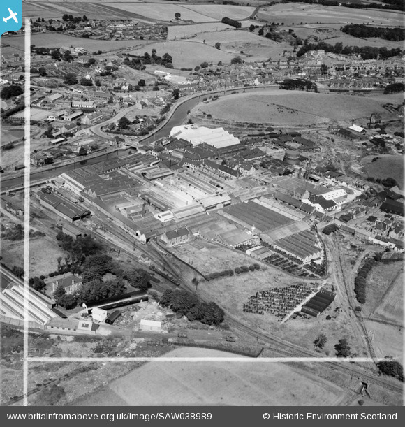
SAW038989 SCOTLAND (1951). Bonnybridge, general view, showing Bonnybridge Gasworks and Smith and Wellstood Ltd. Columbian Stove Works. An oblique aerial photograph taken facing north. This image has been produced from a crop marked negative.
© Hawlfraint cyfranwyr OpenStreetMap a thrwyddedwyd gan yr OpenStreetMap Foundation. 2026. Trwyddedir y gartograffeg fel CC BY-SA.
Delweddau cyfagos (16)
SAW038989

SPW045883

SPW045882

SAW038982

SAW038983

SAW038984

SAW038985

SAW038987

SAW038988

SPW020297

SPW045877

SPW045878

SPW045879

SPW045881

SAW038986

SPW045880

Manylion
| Pennawd | [SAW038989] Bonnybridge, general view, showing Bonnybridge Gasworks and Smith and Wellstood Ltd. Columbian Stove Works. An oblique aerial photograph taken facing north. This image has been produced from a crop marked negative. |
| Cyfeirnod | SAW038989 |
| Dyddiad | 1951 |
| Dolen | NRHE Collection item 1269913 |
| Enw lle | |
| Plwyf | FALKIRK |
| Ardal | FALKIRK |
| Gwlad | SCOTLAND |
| Dwyreiniad / Gogleddiad | 282487, 679853 |
| Hydred / Lledred | -3.8843692638342, 55.997258505361 |
| Cyfeirnod Grid Cenedlaethol | NS825799 |
Pinnau
Byddwch y cyntaf i ychwanegu sylw at y ddelwedd hon!