
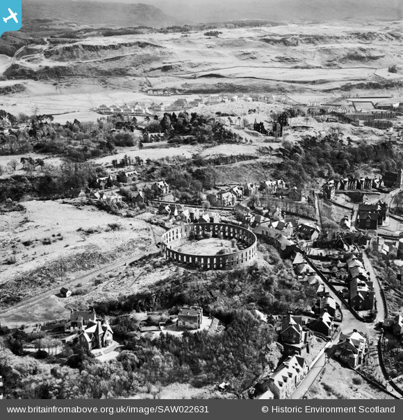
SAW022631 SCOTLAND (1949). Oban, general view, showing McCaig's Tower and Ardconnel Road. An oblique aerial photograph taken facing south.
© Hawlfraint cyfranwyr OpenStreetMap a thrwyddedwyd gan yr OpenStreetMap Foundation. 2026. Trwyddedir y gartograffeg fel CC BY-SA.
Delweddau cyfagos (9)
SAW022631

SPW022117

SAW022628

SAR018780

SAR018781

SAR018782

SAR018784

SAR018790

SAW029873

Manylion
| Pennawd | [SAW022631] Oban, general view, showing McCaig's Tower and Ardconnel Road. An oblique aerial photograph taken facing south. |
| Cyfeirnod | SAW022631 |
| Dyddiad | 1949 |
| Dolen | NRHE Collection item 1269213 |
| Enw lle | |
| Plwyf | KILMORE AND KILBRIDE |
| Ardal | ARGYLL AND BUTE |
| Gwlad | SCOTLAND |
| Dwyreiniad / Gogleddiad | 186105, 730230 |
| Hydred / Lledred | -5.4680483212311, 56.415834112072 |
| Cyfeirnod Grid Cenedlaethol | NM861302 |
Pinnau
Byddwch y cyntaf i ychwanegu sylw at y ddelwedd hon!
Cyfraniadau Grŵp
At the centre of this picture is McKaig's Tower. This was built by a wealthy local banker, and intended as a monument to his family. Based on the Colosseum in Rome, McCaig originally planned it to have a museum, art gallery and central tower, with statues of himself and his family around the inside, but it was left unfinished at his death. It is considered today as an example of the class of buildings known as 'follies' - personal projects, often rather eccentric, which stand as advertisements to their builders' highly individual taste. |

AlMu |
Wednesday 7th of May 2014 11:10:00 AM |