
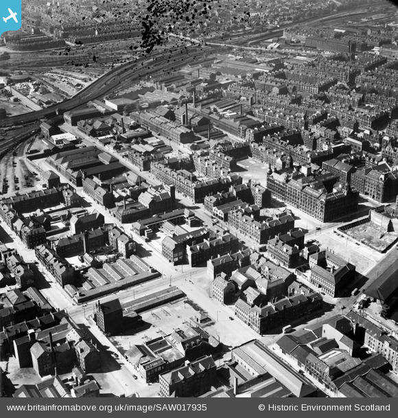
SAW017935 SCOTLAND (1948). Glasgow, general view, showing West Street and Nelson Street. An oblique aerial photograph taken facing south-west. This image has been produced from a damaged negative.
© Hawlfraint cyfranwyr OpenStreetMap a thrwyddedwyd gan yr OpenStreetMap Foundation. 2026. Trwyddedir y gartograffeg fel CC BY-SA.
Delweddau cyfagos (4)
SAW017935

SAR014710

SAR014711

SAR014829

Manylion
| Pennawd | [SAW017935] Glasgow, general view, showing West Street and Nelson Street. An oblique aerial photograph taken facing south-west. This image has been produced from a damaged negative. |
| Cyfeirnod | SAW017935 |
| Dyddiad | 1948 |
| Dolen | NRHE Collection item 1269112 |
| Enw lle | |
| Plwyf | GOVAN (CITY OF GLASGOW) |
| Ardal | CITY OF GLASGOW |
| Gwlad | SCOTLAND |
| Dwyreiniad / Gogleddiad | 258280, 664490 |
| Hydred / Lledred | -4.2641649919827, 55.852777643744 |
| Cyfeirnod Grid Cenedlaethol | NS583645 |
Pinnau

redmist |
Friday 8th of January 2021 02:07:18 PM | |
|
cj |
Sunday 27th of September 2020 07:28:16 PM | |
 |

Billy Turner |
Wednesday 30th of November 2016 06:50:55 PM |
 |
Billy Turner |
Wednesday 3rd of June 2015 10:40:57 PM |
Isn't this the junction of Paterson Street and Wallace Street with the Co-op fruit & veg store on the left (later Sher Bros and still standing) The far away building was Co-op offices. I was born facing the Co-op fruit store. |
BobbyS |
Monday 20th of July 2015 05:32:38 PM |
Yes it is on the corner of Wallace/Paterson Street, my mistake, won't let me edit it. |
Billy Turner |
Wednesday 2nd of September 2015 07:49:06 PM |
|
Billy Turner |
Wednesday 3rd of June 2015 10:31:59 PM | |
|
Billy Turner |
Wednesday 3rd of June 2015 09:49:58 PM | |
|
Billy Turner |
Wednesday 3rd of June 2015 09:37:48 PM | |
|
Billy Turner |
Wednesday 3rd of June 2015 08:54:51 PM | |
|
Billy Turner |
Wednesday 3rd of June 2015 08:50:08 PM | |
|
Billy Turner |
Wednesday 3rd of June 2015 08:23:15 PM | |
|
Billy Turner |
Friday 15th of May 2015 09:53:53 PM | |
|
Billy Turner |
Friday 15th of May 2015 09:44:55 PM | |
|
Billy Turner |
Friday 15th of May 2015 09:42:57 PM | |
|
Billy Turner |
Friday 15th of May 2015 09:32:33 PM | |
|
Billy Turner |
Friday 15th of May 2015 09:01:26 PM | |
|
Billy Turner |
Friday 15th of May 2015 08:54:27 PM | |
|
AlineB |
Thursday 18th of July 2013 11:38:43 PM | |
Attended Centre St School in the fifties, was born and lived in West St until 1955, a happy close knit community. |
AlineB |
Thursday 18th of July 2013 11:45:44 PM |
|
daz |
Monday 4th of February 2013 10:47:14 AM | |
Yes daz you're right,my mother and granny were buried alive in the flattened tenements until rescued.My granny lost everything |
tradeston |
Wednesday 6th of February 2013 06:04:35 PM |
|
Donald Marshall |
Monday 14th of January 2013 02:18:26 AM | |
|
Donald Marshall |
Monday 14th of January 2013 02:16:22 AM | |
|
almoffat |
Thursday 22nd of November 2012 09:10:58 PM | |
This is not ( B1 ) centre st fire station, it's on the wrong side of the road. |
thomasb378 |
Sunday 13th of October 2013 02:22:48 AM |
Almoffat You're 100 per cent wrong re. the Fire station,I lived at 165 Centre street which looked right into the fire station,I also attended Centre street school for 7 years. That is most definitely the fire station. |
tradeston |
Wednesday 13th of November 2013 07:03:52 PM |
When I worked in the area from 1977 to 1988 this was the Fire Station - see the following link: canmore.rcahms.gov.uk/en/site/266967/ Google Earth Street View shows the building converted into housing with the bays for the Fire Engines blocked off. Please "add a pin" to where you think the Fire Station was. |
almoffat |
Thursday 20th of March 2014 09:25:26 PM |
|
almoffat |
Thursday 22nd of November 2012 09:06:34 PM | |
|
almoffat |
Thursday 22nd of November 2012 08:59:39 PM | |
|
almoffat |
Thursday 22nd of November 2012 08:59:08 PM | |
|
almoffat |
Thursday 22nd of November 2012 08:58:03 PM | |
The part of Nelson Street with the annotation tag was actually flattened during the Clydesde blitz in March 1941 with over 120 killed. The low military style buildins was a rest centre for Merchant seamen on the convoys. |
tradeston |
Saturday 1st of December 2012 01:37:54 AM |
|
almoffat |
Thursday 22nd of November 2012 08:57:08 PM | |
|
almoffat |
Thursday 22nd of November 2012 08:56:23 PM | |
|
almoffat |
Thursday 22nd of November 2012 08:55:51 PM |


Cyfraniadau Grŵp
I grew up in this area in the 50's and 60's,it's pretty much a desert now but then it was a hustling bustling docklands neighbourhood.The river Clyde is at the bottom of the picture and this area was heavily bombed during the Blitz which accounts for a lot of the empty spaces in the picture.I never look at this picture without it bringing back happy memories of friends and family no longer with us.Thank you for a great site. Ian in Toronto |
tradeston |
Saturday 25th of August 2012 01:45:59 AM |