
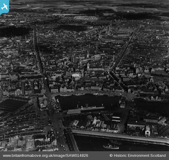
SAW014826 SCOTLAND (1948). Aberdeen, general view, showing Victoria Dock and George Street. An oblique aerial photograph taken facing north. This image has been produced from a print.
© Hawlfraint cyfranwyr OpenStreetMap a thrwyddedwyd gan yr OpenStreetMap Foundation. 2026. Trwyddedir y gartograffeg fel CC BY-SA.
Delweddau cyfagos (27)
SAW014826

SAW019599

SAW019607

SAW022553

SAW019602

SAW022554

SAW022551

SAW022555

SAW022556

SAW022557

SAW022552

SAW019601

SAW019603

SAW019618

SPW060052

SAW022558

SAW022563

SAW022560

SAW022564

SAW022561

SAW014827

SAW022562

SPW022071

SAW019606

SAW019605

SPW060045

SPW060049

Manylion
| Pennawd | [SAW014826] Aberdeen, general view, showing Victoria Dock and George Street. An oblique aerial photograph taken facing north. This image has been produced from a print. |
| Cyfeirnod | SAW014826 |
| Dyddiad | 1948 |
| Dolen | NRHE Collection item 1314745 |
| Enw lle | |
| Plwyf | ABERDEEN |
| Ardal | CITY OF ABERDEEN |
| Gwlad | SCOTLAND |
| Dwyreiniad / Gogleddiad | 394380, 806250 |
| Hydred / Lledred | -2.0928897977009, 57.147286350986 |
| Cyfeirnod Grid Cenedlaethol | NJ944063 |
Pinnau
Byddwch y cyntaf i ychwanegu sylw at y ddelwedd hon!